Distance between Sydney NS and Vancouver BC
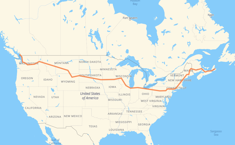
The distance from Sydney to Vancouver is 6,529 kilometers by road including 6,327 kilometers on motorways. Road takes approximately 61 hours and 34 minutes and goes through Moncton, Fredericton, Bangor, Waterville, Augusta, Portland and Lowell.
| Shortest distance by air | 4,585 km ✈️ |
| Car route length | 6,529 km 🚗 |
| Driving time | 61 h 34 min |
| Fuel amount | 522.3 L |
| Fuel cost | 1,023.8 CAD |
| Point | Distance | Time | Fuel | |
| 46.13798, -60.19409 | 0 km | 00 min | 0.0 L | |
|
TCH 495 km, 4 h 58 min
|
||||
| Moncton | 495 km | 4 h 58 min | 77.8 L | |
|
2 170 km, 1 h 32 min
|
||||
| Fredericton | 665 km | 6 h 31 min | 91.7 L | |
|
2 I 95 305 km, 2 h 56 min
|
||||
| Bangor | 970 km | 9 h 27 min | 115.6 L | |
|
I 95 101 km, 55 min
|
||||
| Waterville | 1,071 km | 10 h 23 min | 123.4 L | |
|
I 95 20 km, 11 min
|
||||
| Augusta | 1,092 km | 10 h 34 min | 125.8 L | |
|
I 95 I 295 88 km, 49 min
|
||||
| Portland | 1,179 km | 11 h 24 min | 133.0 L | |
|
I 295 I 95 155 km, 1 h 29 min
|
||||
| Lowell | 1,334 km | 12 h 54 min | 145.5 L | |
|
I 495 I 84 179 km, 1 h 46 min
|
||||
| Hartford | 1,513 km | 14 h 41 min | 159.7 L | |
|
I 84 43 km, 26 min
|
||||
| Waterbury | 1,556 km | 15 h 07 min | 162.9 L | |
|
I 84 261 km, 2 h 34 min
|
||||
| Scranton | 1,818 km | 17 h 42 min | 184.0 L | |
|
I 81 I 80 615 km, 5 h 41 min
|
||||
| Elyria | 2,433 km | 23 h 23 min | 233.3 L | |
|
I 80 137 km, 1 h 14 min
|
||||
| Toledo | 2,570 km | 24 h 38 min | 244.2 L | |
|
I 80 234 km, 2 h 07 min
|
||||
| South Bend | 2,804 km | 26 h 46 min | 262.7 L | |
|
I 80 I 90 315 km, 3 h 02 min
|
||||
| Janesville | 3,119 km | 29 h 48 min | 288.1 L | |
|
I 39 56 km, 30 min
|
||||
| Madison | 3,175 km | 30 h 19 min | 292.2 L | |
|
I 39 I 90 677 km, 6 h 09 min
|
||||
| Brandon | 3,852 km | 36 h 28 min | 346.8 L | |
|
I 90 11 km, 06 min
|
||||
| Sioux Falls | 3,863 km | 36 h 34 min | 347.6 L | |
|
I 90 116 km, 1 h 03 min
|
||||
| Mitchell | 3,980 km | 37 h 38 min | 356.1 L | |
|
I 90 411 km, 3 h 44 min
|
||||
| Box Elder | 4,391 km | 41 h 23 min | 389.4 L | |
|
I 90 19 km, 10 min
|
||||
| Rapid City | 4,409 km | 41 h 33 min | 391.3 L | |
|
I 90 68 km, 36 min
|
||||
| Spearfish | 4,477 km | 42 h 10 min | 396.1 L | |
|
I 90 156 km, 1 h 29 min
|
||||
| Gillette | 4,633 km | 43 h 39 min | 409.0 L | |
|
I 90 160 km, 1 h 34 min
|
||||
| Sheridan | 4,792 km | 45 h 14 min | 421.4 L | |
|
I 90 216 km, 2 h 02 min
|
||||
| Billings | 5,009 km | 47 h 17 min | 438.9 L | |
|
I 90 363 km, 3 h 19 min
|
||||
| Butte | 5,372 km | 50 h 37 min | 466.7 L | |
|
I 90 185 km, 1 h 40 min
|
||||
| Missoula | 5,557 km | 52 h 18 min | 483.2 L | |
|
I 90 265 km, 2 h 27 min
|
||||
| Coeur d'Alene | 5,822 km | 54 h 45 min | 504.2 L | |
|
I 90 55 km, 31 min
|
||||
| Spokane | 5,877 km | 55 h 17 min | 508.3 L | |
|
I 90 179 km, 1 h 37 min
|
||||
| Moses Lake | 6,056 km | 56 h 55 min | 521.4 L | |
|
I 90 254 km, 2 h 20 min
|
||||
| Bellevue | 6,310 km | 59 h 16 min | 543.0 L | |
|
I 405 45 km, 28 min
|
||||
| Everett | 6,354 km | 59 h 44 min | 546.5 L | |
|
I 5 95 km, 54 min
|
||||
| Bellingham | 6,449 km | 60 h 39 min | 553.8 L | |
|
I 5 99 90 km, 1 h 00 min
|
||||
| Vancouver | 6,539 km | 61 h 39 min | 561.4 L | |
Hotels of Vancouver
Frequently Asked Questions
How much does it cost to drive from Sydney to Vancouver?
Fuel cost: 1,023.8 CAD
This fuel cost is calculated as: (Route length 6,529 km / 100 km) * (Fuel consumption 8 L/100 km) * (Fuel price 1.96 CAD / L)
You can adjust fuel consumption and fuel price here.
How long is a car ride from Sydney to Vancouver?
Driving time: 61 h 34 min
This time is calculated for driving at the maximum permitted speed, taking into account traffic rules restrictions.
- 4,837 km with a maximum speed 110 km/h = 43 h 58 min
- 692 km with a maximum speed 105 km/h = 6 h 37 min
- 384 km with a maximum speed 100 km/h = 3 h 50 min
- 159 km with a maximum speed 97 km/h = 1 h 39 min
- 156 km with a maximum speed 90 km/h = 1 h 44 min
- 89 km with a maximum speed 89 km/h = 1 h
- 14 km with a maximum speed 80 km/h = 10 min
- 171 km with a maximum speed 80 km/h = 2 h 8 min
- 5 km with a maximum speed 72 km/h = 4 min
- 7 km with a maximum speed 70 km/h = 5 min
- 1 km with a maximum speed 64 km/h = 1 min
- 2 km with a maximum speed 60 km/h = 2 min
- 9 km with a maximum speed 50 km/h = 11 min
The calculated driving time does not take into account intermediate stops and traffic jams.
How far is Sydney to Vancouver by land?
The distance between Sydney and Vancouver is 6,529 km by road including 6,327 km on motorways.
Precise satellite coordinates of highways were used for this calculation. The start and finish points are the centers of Sydney and Vancouver respectively.
How far is Sydney to Vancouver by plane?
The shortest distance (air line, as the crow flies) between Sydney and Vancouver is 4,585 km.
This distance is calculated using the Haversine formula as a great-circle distance between two points on the surface of a sphere. The start and finish points are the centers of Sydney and Vancouver respectively. Actual distance between airports may be different.
How many hours is Sydney from Vancouver by plane?
Boeing 737 airliner needs 5 h 43 min to cover the distance of 4,585 km at a cruising speed of 800 km/h.
Small plane "Cessna 172" needs 20 h 50 min to flight this distance at average speed of 220 km/h.
This time is approximate and do not take into account takeoff and landing times, airport location and other real world factors.
How long is a helicopter ride from Sydney to Vancouver?
Fast helicopter "Eurocopter AS350" or "Hughes OH-6 Cayuse" need 19 h 6 min to cover the distance of 4,585 km at a cruising speed of 240 km/h.
Popular "Robinson R44" needs 21 h 50 min to flight this distance at average speed of 210 km/h.
This time is approximate and do not take into account takeoff and landing times, aerodrome location and other real world factors.
What city is halfway between Sydney and Vancouver?
The halfway point between Sydney and Vancouver is Wisconsin Dells. It is located about 6 km from the exact midpoint by road.
The distance from Wisconsin Dells to Sydney is 3,271 km and driving will take about 31 h 9 min. The road between Wisconsin Dells and Vancouver has length 3,258 km and will take approximately 30 h 25 min.
The other cities located close to halfway point:
Where is Sydney in relation to Vancouver?
Sydney is located 4,585 km east of Vancouver.
Sydney has geographic coordinates: latitude 46.13798, longitude -60.19409.
Vancouver has geographic coordinates: latitude 49.26243, longitude -123.11554.
Which highway goes from Sydney to Vancouver?
The route from Sydney to Vancouver follows I 90, I 80, I 95, TCH, I 84, 2, US 14, NS 104, US 87, I 94, I 39, I 5, NS 105, US 212, US 12, I 495.
Other minor sections pass along the road:
- US 395: 95 km
- US 191: 92 km
- I 295: 86 km
- I 81: 56 km
- SD 79: 50 km
- US 16: 40 km
- 99: 38 km
- US 6: 37 km
- US 83: 31 km
- US 51: 30 km
- I 405: 30 km
- US 220: 26 km
- US 41: 22 km
- MT 200: 22 km
- NS 125: 19 km
- 95: 14 km
- I 15: 12 km
- US 85: 12 km
- 7: 11 km
- US 89: 11 km
- NY 52: 11 km
- SD 63: 11 km
- SD 73: 10 km
- SD 50: 10 km
- SD 34: 10 km
- NS 4: 9 km
- US 93: 8 km
- SD 45: 7 km
- US 61: 7 km
- SR 11: 6 km
- 105: 6 km
- US 1: 6 km
- PA 66: 6 km
- US 16 Truck: 6 km
- US 97: 6 km
- US 7: 6 km
- PA 309: 6 km
- I 380: 5 km
- US 202: 5 km
- US 220 Alternate: 5 km
- ME 15: 4 km
- US 2: 4 km
- MN 43: 4 km
- PA 28 Truck: 4 km
- US 218: 3 km
- US 20: 3 km
- WI 11: 3 km
- 15: 2 km
- SD 37: 2 km
- US 53: 1 km
- WA 543: 1 km