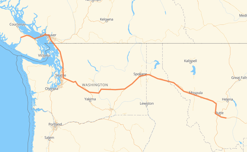
The distance from Port Alberni to Whitehall is 1,373 kilometers by road including 1,237 kilometers on motorways. Road takes approximately 15 hours and 37 minutes and goes through Parksville, Nanaimo, West Vancouver, District of North Vancouver, Vancouver, Burnaby and New Westminster.
How much does it cost to drive from Port Alberni to Whitehall?
Fuel cost:
215.3 CAD
This fuel cost is calculated as: (Route length 1,373 km / 100 km) * (Fuel consumption 8 L/100 km) * (Fuel price 1.96 CAD / L)
You can adjust fuel consumption and fuel price here.
How long is a car ride from Port Alberni to Whitehall?
Driving time:
15 h 37 min
This time is calculated for driving at the maximum permitted speed, taking into account traffic rules restrictions.
915 km with a maximum speed 110 km/h = 8 h 19 min
102 km with a maximum speed 105 km/h = 58 min
15 km with a maximum speed 100 km/h = 8 min
147 km with a maximum speed 97 km/h = 1 h 31 min
34 km with a maximum speed 90 km/h = 22 min
7 km with a maximum speed 89 km/h = 4 min
69 km with a maximum speed 80 km/h = 51 min
10 km with a maximum speed 70 km/h = 8 min
9 km with a maximum speed 60 km/h = 9 min
7 km with a maximum speed 50 km/h = 8 min
57 km with a maximum speed 20 km/h = 2 h 52 min
The calculated driving time does not take into account intermediate stops and traffic jams.
How far is Port Alberni to Whitehall by land?
The distance between Port Alberni and Whitehall is 1,373 km by road including 1,237 km on motorways.
Precise satellite coordinates of highways were used for this calculation. The start and finish points are the centers of Port Alberni and Whitehall respectively.
How far is Port Alberni to Whitehall by plane?
The shortest distance (air line, as the crow flies) between Port Alberni and Whitehall is 1,023 km.
This distance is calculated using the Haversine formula as a great-circle distance between two points on the surface of a sphere. The start and finish points are the centers of Port Alberni and Whitehall respectively. Actual distance between airports may be different.
How many hours is Port Alberni from Whitehall by plane?
Boeing 737 airliner needs 1 h 16 min to cover the distance of 1,023 km at a cruising speed of 800 km/h.
Small plane "Cessna 172" needs 4 h 39 min to flight this distance at average speed of 220 km/h.
This time is approximate and do not take into account takeoff and landing times, airport location and other real world factors.
How long is a helicopter ride from Port Alberni to Whitehall?
Fast helicopter "Eurocopter AS350" or "Hughes OH-6 Cayuse" need 4 h 15 min to cover the distance of 1,023 km at a cruising speed of 240 km/h.
Popular "Robinson R44" needs 4 h 52 min to flight this distance at average speed of 210 km/h.
This time is approximate and do not take into account takeoff and landing times, aerodrome location and other real world factors.
What city is halfway between Port Alberni and Whitehall?
The halfway point between Port Alberni and Whitehall is Weber.
The distance from Weber to Port Alberni is 686 km and driving will take about 9 h 16 min. The road between Weber and Whitehall has length 687 km and will take approximately 6 h 20 min.
The other cities located close to halfway point:
Barham is in 677 km from Port Alberni and 696 km from Whitehall
Moses Lake is in 644 km from Port Alberni and 729 km from Whitehall
George is in 616 km from Port Alberni and 756 km from Whitehall
Where is Port Alberni in relation to Whitehall?
Port Alberni is located 1,023 km west of Whitehall.
Port Alberni has geographic coordinates: latitude 49.23553, longitude -124.80743.
Whitehall has geographic coordinates: latitude 45.87076, longitude -112.09749.
Which highway goes from Port Alberni to Whitehall?
The route from Port Alberni to Whitehall follows I 90, I 5, US 12.