Distance between Winnipeg MB and Quebec QC
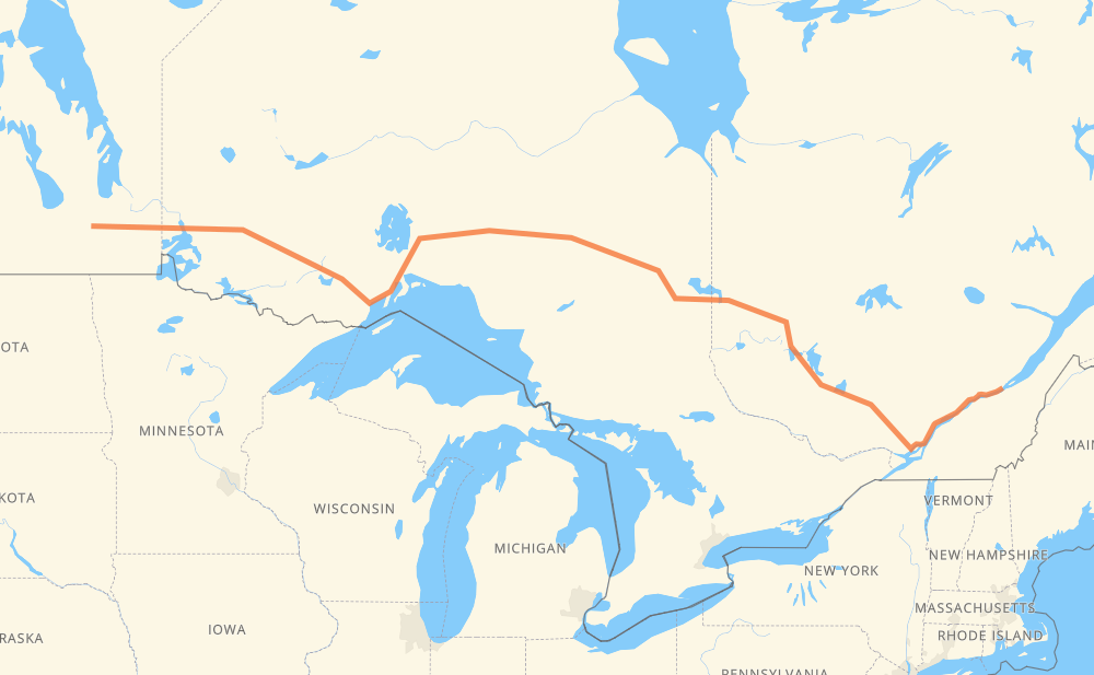
The distance from Winnipeg to Quebec is 2,505 kilometers by road including 341 kilometers on motorways. Road takes approximately 28 hours and 17 minutes and goes through Kenora, Dryden, Thunder Bay, Rouyn-Noranda and Trois-Rivières.
| Shortest distance by air | 1,937 km ✈️ |
| Car route length | 2,505 km 🚗 |
| Driving time | 28 h 17 min |
| Fuel amount | 200.4 L |
| Fuel cost | 380.7 CAD |
| Point | Distance | Time | Fuel | |
| Winnipeg | 0 km | 00 min | 0.0 L | |
|
PTH 1 152 km, 1 h 44 min
|
||||
| West Hawk Lake | 152 km | 1 h 44 min | 11.6 L | |
|
PTH 1 17 59 km, 39 min
|
||||
| Kenora | 212 km | 2 h 24 min | 16.6 L | |
|
17A 17 146 km, 1 h 40 min
|
||||
| Dryden | 358 km | 4 h 04 min | 28.0 L | |
|
17 99 km, 1 h 09 min
|
||||
| Ignace | 457 km | 5 h 13 min | 35.6 L | |
|
17 235 km, 2 h 37 min
|
||||
| Thunder Bay | 692 km | 7 h 51 min | 55.3 L | |
|
17 11 108 km, 1 h 12 min
|
||||
| Nipigon | 800 km | 9 h 03 min | 63.5 L | |
|
11 841 km, 9 h 41 min
|
||||
| Rouyn-Noranda | 1,641 km | 18 h 45 min | 130.4 L | |
|
117 734 km, 8 h 11 min
|
||||
| Trois-Rivières | 2,375 km | 26 h 56 min | 189.9 L | |
|
40 129 km, 1 h 20 min
|
||||
| Quebec | 2,505 km | 28 h 17 min | 199.0 L | |
Hotels of Quebec
Frequently Asked Questions
How much does it cost to drive from Winnipeg to Quebec?
Fuel cost: 380.7 CAD
This fuel cost is calculated as: (Route length 2,505 km / 100 km) * (Fuel consumption 8 L/100 km) * (Fuel price 1.9 CAD / L)
You can adjust fuel consumption and fuel price here.
How long is a car ride from Winnipeg to Quebec?
Driving time: 28 h 17 min
This time is calculated for driving at the maximum permitted speed, taking into account traffic rules restrictions.
- 329 km with a maximum speed 100 km/h = 3 h 17 min
- 1,963 km with a maximum speed 90 km/h = 21 h 48 min
- 92 km with a maximum speed 80 km/h = 1 h 8 min
- 54 km with a maximum speed 70 km/h = 46 min
- 19 km with a maximum speed 60 km/h = 19 min
- 46 km with a maximum speed 50 km/h = 54 min
The calculated driving time does not take into account intermediate stops and traffic jams.
How far is Winnipeg to Quebec by land?
The distance between Winnipeg and Quebec is 2,505 km by road including 341 km on motorways.
Precise satellite coordinates of highways were used for this calculation. The start and finish points are the centers of Winnipeg and Quebec respectively.
How far is Winnipeg to Quebec by plane?
The shortest distance (air line, as the crow flies) between Winnipeg and Quebec is 1,937 km.
This distance is calculated using the Haversine formula as a great-circle distance between two points on the surface of a sphere. The start and finish points are the centers of Winnipeg and Quebec respectively. Actual distance between airports may be different.
How many hours is Winnipeg from Quebec by plane?
Boeing 737 airliner needs 2 h 25 min to cover the distance of 1,937 km at a cruising speed of 800 km/h.
Small plane "Cessna 172" needs 8 h 48 min to flight this distance at average speed of 220 km/h.
This time is approximate and do not take into account takeoff and landing times, airport location and other real world factors.
How long is a helicopter ride from Winnipeg to Quebec?
Fast helicopter "Eurocopter AS350" or "Hughes OH-6 Cayuse" need 8 h 4 min to cover the distance of 1,937 km at a cruising speed of 240 km/h.
Popular "Robinson R44" needs 9 h 13 min to flight this distance at average speed of 210 km/h.
This time is approximate and do not take into account takeoff and landing times, aerodrome location and other real world factors.
What city is halfway between Winnipeg and Quebec?
The halfway point between Winnipeg and Quebec is Opasatika. It is located about 7 km from the exact midpoint by road.
The distance from Opasatika to Winnipeg is 1,260 km and driving will take about 14 h 15 min. The road between Opasatika and Quebec has length 1,245 km and will take approximately 14 h 1 min.
The other cities located close to halfway point:
Where is Winnipeg in relation to Quebec?
Winnipeg is located 1,937 km west of Quebec.
Winnipeg has geographic coordinates: latitude 49.88402, longitude -97.16858.
Quebec has geographic coordinates: latitude 46.82591, longitude -71.23501.
Which highway goes from Winnipeg to Quebec?
The route from Winnipeg to Quebec follows 11, 17, 117, 40, PTH 1, 101.
Other minor sections pass along the road:
- 15: 69 km
- 17A: 33 km
- 102: 33 km
- 640: 32 km
- 388: 22 km
- 393: 16 km
- 440: 4 km
- Route 115: 3 km
- Route 20: 3 km
- PTH 59: 3 km
- PR 206: 2 km
- 55: 2 km
- Route 135: 1 km
- 583: 1 km