Distance between Wyspa Sobieszewska and Hela
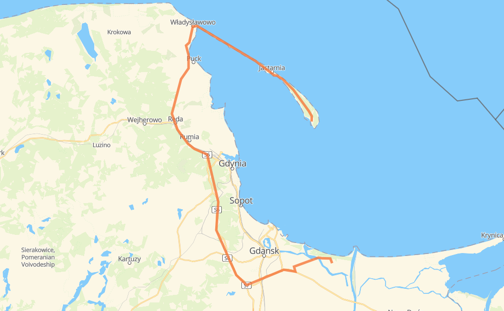
The distance from Wyspa Sobieszewska to Hela is 122 kilometers by road. Road takes approximately 1 hour and 51 minutes and goes through Orunia - Święty Wojciech - Lipce, Mattern, Espenkrug, Pustkowie, Rekowo Dolne and Heisternest.
| Shortest distance by air | 30 km ✈️ |
| Car route length | 122 km 🚗 |
| Driving time | 1 h 51 min |
| Fuel amount | 9.8 L |
| Fuel cost | 19.2 CAD |
| Point | Distance | Time | Fuel | |
| 54.33579, 18.87193 | 0 km | 00 min | 0.0 L | |
|
501 7 km, 08 min
|
||||
| Wiślinka | 7 km | 08 min | 0.9 L | |
|
501 4 km, 02 min
|
||||
| Przejazdowo | 11 km | 11 min | 1.3 L | |
|
226 S7 8 km, 06 min
|
||||
| Orunia - Święty Wojciech - Lipce | 19 km | 17 min | 1.7 L | |
|
S7 S6 18 km, 12 min
|
||||
| Mattern | 37 km | 30 min | 3.3 L | |
|
S6 3 km, 02 min
|
||||
| Espenkrug | 40 km | 32 min | 3.5 L | |
|
S6 14 km, 10 min
|
||||
| Pustkowie | 54 km | 42 min | 4.6 L | |
|
S6 6 14 km, 16 min
|
||||
| Rekowo Dolne | 68 km | 58 min | 5.8 L | |
|
216 3 km, 02 min
|
||||
| Widlino | 71 km | 1 h 00 min | 6.0 L | |
|
216 36 km, 32 min
|
||||
| Heisternest | 107 km | 1 h 33 min | 8.6 L | |
|
216 16 km, 18 min
|
||||
| Hela | 122 km | 1 h 51 min | 9.8 L | |
Hotels of Hela
Frequently Asked Questions
How much does it cost to drive from Wyspa Sobieszewska to Hela?
Fuel cost: 19.2 CAD
This fuel cost is calculated as: (Route length 122 km / 100 km) * (Fuel consumption 8 L/100 km) * (Fuel price 1.96 CAD / L)
You can adjust fuel consumption and fuel price here.
How long is a car ride from Wyspa Sobieszewska to Hela?
Driving time: 1 h 51 min
This time is calculated for driving at the maximum permitted speed, taking into account traffic rules restrictions.
- 55 km with a maximum speed 90 km/h = 36 min
- 7 km with a maximum speed 80 km/h = 5 min
- 16 km with a maximum speed 70 km/h = 13 min
- 3 km with a maximum speed 60 km/h = 2 min
- 38 km with a maximum speed 50 km/h = 45 min
- 3 km with a maximum speed 40 km/h = 4 min
- 1 km with a maximum speed 30 km/h = 1 min
- 1 km with a maximum speed 20 km/h = 2 min
The calculated driving time does not take into account intermediate stops and traffic jams.
How far is Wyspa Sobieszewska to Hela by land?
The distance between Wyspa Sobieszewska and Hela is 122 km by road.
Precise satellite coordinates of highways were used for this calculation. The start and finish points are the centers of Wyspa Sobieszewska and Hela respectively.
What city is halfway between Wyspa Sobieszewska and Hela?
The halfway point between Wyspa Sobieszewska and Hela is Rekowo Dolne. It is located about 7 km from the exact midpoint by road.
The distance from Rekowo Dolne to Wyspa Sobieszewska is 68 km and driving will take about 58 min. The road between Rekowo Dolne and Hela has length 54 km and will take approximately 53 min.
The other cities located close to halfway point:
Where is Wyspa Sobieszewska in relation to Hela?
Wyspa Sobieszewska is located 30 km south of Hela.
Wyspa Sobieszewska has geographic coordinates: latitude 54.33579, longitude 18.87193.
Hela has geographic coordinates: latitude 54.60664, longitude 18.80271.
Which highway goes from Wyspa Sobieszewska to Hela?
The route from Wyspa Sobieszewska to Hela follows 216.
Other minor sections pass along the road:
- S6: 31 km
- S7: 19 km
- 6: 10 km
- 501: 9 km