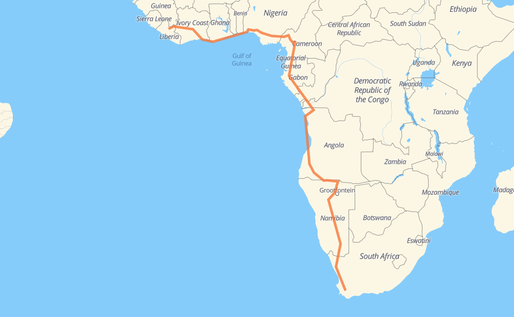
Distance between Worcester and Town
The distance from Worcester to Town is 9,067 kilometers by road including 400 kilometers on motorways. Road takes approximately 109 hours and 54 minutes and goes through Okahandja, Otjiwarongo, Ondjiva, Benguela, Lobito, Sumbe and M'banza Congo.
| Shortest distance by air | 5,449 km ✈️ |
| Car route length | 9,067 km 🚗 |
| Driving time | 109 h 54 min |
| Fuel amount | 725.4 L |
| Fuel cost | 1,421.8 CAD |
| Point | Distance | Time | Fuel | |
| -33.64624, 19.44593 | 0 km | 00 min | 0.0 L | |
|
B1 1,529 km, 17 h 03 min
|
||||
| Okahandja | 1,529 km | 17 h 03 min | 244.2 L | |
|
B1 176 km, 1 h 57 min
|
||||
| Otjiwarongo | 1,705 km | 19 h 01 min | 258.4 L | |
|
B1 B10 679 km, 7 h 38 min
|
||||
| Ondjiva | 2,384 km | 26 h 40 min | 311.3 L | |
|
EN120 EN105 747 km, 8 h 56 min
|
||||
| Benguela | 3,131 km | 35 h 37 min | 372.5 L | |
|
EN100 28 km, 21 min
|
||||
| Lobito | 3,159 km | 35 h 58 min | 374.4 L | |
|
EN260 EN100 182 km, 2 h 05 min
|
||||
| Sumbe | 3,340 km | 38 h 04 min | 389.1 L | |
|
EN100 832 km, 9 h 36 min
|
||||
| M'banza Congo | 4,172 km | 47 h 40 min | 452.8 L | |
|
EN120 RN1 435 km, 6 h 20 min
|
||||
| Dolisie | 4,607 km | 54 h 01 min | 489.9 L | |
|
P2 RN2 1,208 km, 14 h 52 min
|
||||
| Ebolowa | 5,815 km | 68 h 53 min | 586.8 L | |
|
N 2 N2 108 km, 1 h 21 min
|
||||
| Mbalmayo | 5,923 km | 70 h 14 min | 594.3 L | |
|
N2 53 km, 39 min
|
||||
| Yaounde | 5,976 km | 70 h 54 min | 599.7 L | |
|
N1 N4 129 km, 1 h 36 min
|
||||
| Bafia | 6,105 km | 72 h 31 min | 609.6 L | |
|
N4 168 km, 2 h 06 min
|
||||
| Bafoussam | 6,273 km | 74 h 38 min | 624.0 L | |
|
N6 566 km, 7 h 10 min
|
||||
| Onitsha | 6,839 km | 81 h 49 min | 668.9 L | |
|
A6 A121-1 377 km, 4 h 39 min
|
||||
| Sagamu | 7,217 km | 86 h 28 min | 698.5 L | |
|
A121-1 F100 188 km, 2 h 17 min
|
||||
| Cotonou | 7,405 km | 88 h 45 min | 713.9 L | |
|
RNIE 1 9 km, 06 min
|
||||
| Abomey-Calavi | 7,413 km | 88 h 51 min | 715.1 L | |
|
RNIE 1 165 km, 2 h 25 min
|
||||
| Lomé | 7,578 km | 91 h 16 min | 727.7 L | |
|
N2 N1 171 km, 2 h 06 min
|
||||
| Ashaiman | 7,749 km | 93 h 23 min | 741.7 L | |
|
N1 527 km, 6 h 38 min
|
||||
| Port-Bouët | 8,276 km | 100 h 02 min | 783.2 L | |
|
A100 14 km, 09 min
|
||||
| Koumassi | 8,290 km | 100 h 12 min | 785.2 L | |
|
3 km, 02 min
|
||||
| Marcory | 8,292 km | 100 h 14 min | 785.4 L | |
|
2 km, 01 min
|
||||
| Treichville | 8,294 km | 100 h 16 min | 785.6 L | |
|
3 km, 02 min
|
||||
| Le Plateau | 8,297 km | 100 h 18 min | 785.7 L | |
|
4 km, 04 min
|
||||
| Attécoubé | 8,301 km | 100 h 23 min | 786.0 L | |
|
9 km, 07 min
|
||||
| Yopougon | 8,310 km | 100 h 30 min | 786.4 L | |
|
A3 220 km, 2 h 06 min
|
||||
| Yamoussoukro | 8,530 km | 102 h 36 min | 804.3 L | |
|
A3 A6 153 km, 1 h 48 min
|
||||
| Daloa | 8,683 km | 104 h 25 min | 815.4 L | |
|
A6 A7 433 km, 5 h 29 min
|
||||
| Dementa | 9,116 km | 109 h 54 min | 851.2 L | |
Frequently Asked Questions
How much does it cost to drive from Worcester to Town?
Fuel cost: 1,421.8 CAD
This fuel cost is calculated as: (Route length 9,067 km / 100 km) * (Fuel consumption 8 L/100 km) * (Fuel price 1.96 CAD / L)
You can adjust fuel consumption and fuel price here.
How long is a car ride from Worcester to Town?
Driving time: 109 h 54 min
This time is calculated for driving at the maximum permitted speed, taking into account traffic rules restrictions.
- 247 km with a maximum speed 110 km/h = 2 h 14 min
- 70 km with a maximum speed 100 km/h = 41 min
- 4,334 km with a maximum speed 90 km/h = 48 h 9 min
- 4,029 km with a maximum speed 80 km/h = 50 h 21 min
- 13 km with a maximum speed 70 km/h = 10 min
- 54 km with a maximum speed 60 km/h = 53 min
- 44 km with a maximum speed 55 km/h = 47 min
- 323 km with a maximum speed 50 km/h = 6 h 27 min
- 1 km with a maximum speed 40 km/h = 1 min
- 1 km with a maximum speed 30 km/h = 1 min
- 2 km with a maximum speed 20 km/h = 4 min
The calculated driving time does not take into account intermediate stops and traffic jams.
How far is Worcester to Town by land?
The distance between Worcester and Town is 9,067 km by road including 400 km on motorways.
Precise satellite coordinates of highways were used for this calculation. The start and finish points are the centers of Worcester and Town respectively.
How far is Worcester to Town by plane?
The shortest distance (air line, as the crow flies) between Worcester and Town is 5,449 km.
This distance is calculated using the Haversine formula as a great-circle distance between two points on the surface of a sphere. The start and finish points are the centers of Worcester and Town respectively. Actual distance between airports may be different.
How many hours is Worcester from Town by plane?
Boeing 737 airliner needs 6 h 48 min to cover the distance of 5,449 km at a cruising speed of 800 km/h.
Small plane "Cessna 172" needs 24 h 46 min to flight this distance at average speed of 220 km/h.
This time is approximate and do not take into account takeoff and landing times, airport location and other real world factors.
How long is a helicopter ride from Worcester to Town?
Fast helicopter "Eurocopter AS350" or "Hughes OH-6 Cayuse" need 22 h 42 min to cover the distance of 5,449 km at a cruising speed of 240 km/h.
Popular "Robinson R44" needs 25 h 56 min to flight this distance at average speed of 210 km/h.
This time is approximate and do not take into account takeoff and landing times, aerodrome location and other real world factors.
What city is halfway between Worcester and Town?
Where is Worcester in relation to Town?
Worcester is located 5,449 km south-east of Town.
Worcester has geographic coordinates: latitude -33.64624, longitude 19.44593.
Town has geographic coordinates: latitude 6.96504, longitude -9.46476.
Which highway goes from Worcester to Town?
The route from Worcester to Town follows B1, EN100, EN105, N1, RN1, N7, RN2, N2, N6, B10, A6, A121-1, A3, N4, B15, EN120, RN 3, A100, RNIE 1, A232.
Other minor sections pass along the road:
- P2: 97 km
- A4: 93 km
- EN260: 93 km
- EN215: 82 km
- A7: 79 km
- F100: 77 km
- A8: 69 km
- TAH 7: 66 km
- A1: 64 km
- RS107: 53 km
- N 4: 47 km
- E1: 45 km
- EN100A: 44 km
- R44: 37 km
- R43: 35 km
- EN280: 32 km
- EN110: 31 km
- N 2: 27 km
- RN12: 26 km
- RN 6: 20 km
- R46: 20 km
- RS108: 14 km
- RN15: 13 km
- RNIE 1 T: 10 km
- C10: 6 km
- N3: 5 km
- A3-1: 3 km
- D63: 2 km
- RS103: 2 km
- EN372: 2 km
- RP101: 2 km