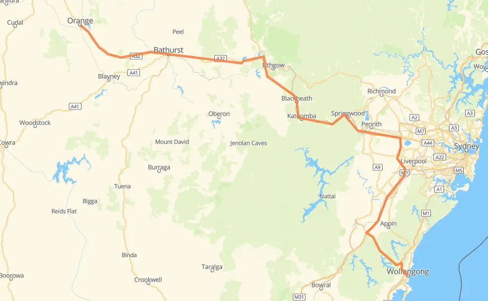
The distance from Wollongong to Orange is 312 kilometers by road including 85 kilometers on motorways. Road takes approximately 3 hours and 41 minutes and goes through Bathurst, North Wollongong, Fairy Meadow, Mount Ousley, Keiraville, Mount Pleasant and Balgownie.
How much does it cost to drive from Wollongong to Orange?
Fuel cost:
49 CAD
This fuel cost is calculated as: (Route length 312 km / 100 km) * (Fuel consumption 8 L/100 km) * (Fuel price 1.96 CAD / L)
You can adjust fuel consumption and fuel price here.
How long is a car ride from Wollongong to Orange?
Driving time:
3 h 41 min
This time is calculated for driving at the maximum permitted speed, taking into account traffic rules restrictions.
51 km with a maximum speed 110 km/h = 28 min
25 km with a maximum speed 100 km/h = 14 min
118 km with a maximum speed 90 km/h = 1 h 18 min
68 km with a maximum speed 80 km/h = 50 min
18 km with a maximum speed 70 km/h = 15 min
28 km with a maximum speed 60 km/h = 28 min
4 km with a maximum speed 50 km/h = 5 min
The calculated driving time does not take into account intermediate stops and traffic jams.
How far is Wollongong to Orange by land?
The distance between Wollongong and Orange is 312 km by road including 85 km on motorways.
Precise satellite coordinates of highways were used for this calculation. The start and finish points are the centers of Wollongong and Orange respectively.
How far is Wollongong to Orange by plane?
The shortest distance (air line, as the crow flies) between Wollongong and Orange is 209 km.
This distance is calculated using the Haversine formula as a great-circle distance between two points on the surface of a sphere. The start and finish points are the centers of Wollongong and Orange respectively. Actual distance between airports may be different.
How many hours is Wollongong from Orange by plane?
Boeing 737 airliner needs 15 min to cover the distance of 209 km at a cruising speed of 800 km/h.
Small plane "Cessna 172" needs 57 min to flight this distance at average speed of 220 km/h.
This time is approximate and do not take into account takeoff and landing times, airport location and other real world factors.
How long is a helicopter ride from Wollongong to Orange?
Fast helicopter "Eurocopter AS350" or "Hughes OH-6 Cayuse" need 52 min to cover the distance of 209 km at a cruising speed of 240 km/h.
Popular "Robinson R44" needs 59 min to flight this distance at average speed of 210 km/h.
This time is approximate and do not take into account takeoff and landing times, aerodrome location and other real world factors.
What city is halfway between Wollongong and Orange?
The halfway point between Wollongong and Orange is Leura.
The distance from Leura to Wollongong is 156 km and driving will take about 1 h 43 min. The road between Leura and Orange has length 156 km and will take approximately 1 h 57 min.
The other cities located close to halfway point:
Wentworth Falls is in 153 km from Wollongong and 159 km from Orange
Katoomba is in 161 km from Wollongong and 152 km from Orange
Bullaburra is in 148 km from Wollongong and 164 km from Orange
Where is Wollongong in relation to Orange?
Wollongong is located 209 km south-east of Orange.
Wollongong has geographic coordinates: latitude -34.4244, longitude 150.89384.
Orange has geographic coordinates: latitude -33.28205, longitude 149.09716.