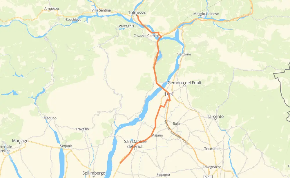
Distance between Villanova di San Daniele and Tolmezzo
The distance from Villanova di San Daniele to Tolmezzo is 41 kilometers by road including 16 kilometers on motorways. Road takes approximately 31 minutes and goes through Klemaun, San Daniele del Friuli, Rivoli and Somplago.
| Shortest distance by air | 30 km ✈️ |
| Car route length | 41 km 🚗 |
| Driving time | 31 min |
| Fuel amount | 3.3 L |
| Fuel cost | 6.4 CAD |
| Point | Distance | Time | Fuel | |
| Villanova di San Daniele | 0 km | 00 min | 0.0 L | |
|
SR463 4 km, 03 min
|
||||
| San Daniele del Friuli | 4 km | 03 min | 0.2 L | |
|
SR463 4 km, 02 min
|
||||
| San Tomaso | 8 km | 06 min | 0.6 L | |
|
SR463 1 km, 00 min
|
||||
| Comerzo | 9 km | 06 min | 0.7 L | |
|
SR463 4 km, 03 min
|
||||
| Rivoli | 13 km | 09 min | 1.0 L | |
|
SR463 5 km, 04 min
|
||||
| Klemaun | 18 km | 14 min | 1.3 L | |
|
A23 13 km, 07 min
|
||||
| Somplago | 31 km | 22 min | 2.4 L | |
|
A23 1 km, 00 min
|
||||
| Villaggio Pic | 32 km | 22 min | 2.5 L | |
|
A23 SS52 9 km, 08 min
|
||||
| Tolmezzo | 41 km | 31 min | 3.0 L | |
Frequently Asked Questions
How much does it cost to drive from Villanova di San Daniele to Tolmezzo?
Fuel cost: 6.4 CAD
This fuel cost is calculated as: (Route length 41 km / 100 km) * (Fuel consumption 8 L/100 km) * (Fuel price 1.93 CAD / L)
You can adjust fuel consumption and fuel price here.
How long is a car ride from Villanova di San Daniele to Tolmezzo?
Driving time: 31 min
This time is calculated for driving at the maximum permitted speed, taking into account traffic rules restrictions.
- 14 km with a maximum speed 110 km/h = 7 min
- 11 km with a maximum speed 90 km/h = 7 min
- 9 km with a maximum speed 80 km/h = 6 min
- 5 km with a maximum speed 50 km/h = 6 min
- 2 km with a maximum speed 40 km/h = 3 min
The calculated driving time does not take into account intermediate stops and traffic jams.
How far is Villanova di San Daniele to Tolmezzo by land?
The distance between Villanova di San Daniele and Tolmezzo is 41 km by road including 16 km on motorways.
Precise satellite coordinates of highways were used for this calculation. The start and finish points are the centers of Villanova di San Daniele and Tolmezzo respectively.
What city is halfway between Villanova di San Daniele and Tolmezzo?
The halfway point between Villanova di San Daniele and Tolmezzo is Klemaun. It is located about 2 km from the exact midpoint by road.
The distance from Klemaun to Villanova di San Daniele is 18 km and driving will take about 14 min. The road between Klemaun and Tolmezzo has length 23 km and will take approximately 16 min.
Where is Villanova di San Daniele in relation to Tolmezzo?
Villanova di San Daniele is located 30 km south of Tolmezzo.
Villanova di San Daniele has geographic coordinates: latitude 46.13365, longitude 12.97047.
Tolmezzo has geographic coordinates: latitude 46.40537, longitude 13.01584.
Which highway goes from Villanova di San Daniele to Tolmezzo?
The route from Villanova di San Daniele to Tolmezzo follows SR463, A23.
Other minor sections pass along the road:
- SS52: 4 km