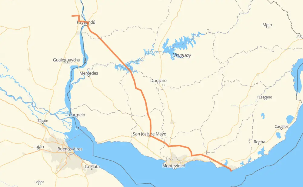
Distance between Villa Elisa and Punta del Este
The distance from Villa Elisa to Punta del Este is 531 kilometers by road. Road takes approximately 6 hours and 20 minutes and goes through Young, Trinidad, San José de Mayo, Santa Lucía and Canelones.
| Shortest distance by air | 447 km ✈️ |
| Car route length | 531 km 🚗 |
| Driving time | 6 h 20 min |
| Fuel amount | 42.5 L |
| Fuel cost | 82 CAD |
| Point | Distance | Time | Fuel | |
| Villa Elisa | 0 km | 00 min | 0.0 L | |
|
RN130 RN135 45 km, 31 min
|
||||
| Nuevo Paysandú | 45 km | 31 min | 3.3 L | |
|
13 km, 09 min
|
||||
| Chacras de Paysandú | 58 km | 41 min | 3.9 L | |
|
3 57 km, 39 min
|
||||
| Young | 115 km | 1 h 20 min | 9.1 L | |
|
3 121 km, 1 h 23 min
|
||||
| Trinidad | 236 km | 2 h 43 min | 18.7 L | |
|
3 96 km, 1 h 09 min
|
||||
| San José de Mayo | 332 km | 3 h 53 min | 26.4 L | |
|
11 36 km, 28 min
|
||||
| Santa Lucía | 368 km | 4 h 21 min | 29.2 L | |
|
11 11 km, 09 min
|
||||
| Canelones | 379 km | 4 h 30 min | 30.2 L | |
|
11 40 km, 27 min
|
||||
| San Jacinto | 419 km | 4 h 58 min | 33.4 L | |
|
11 IB 111 km, 1 h 21 min
|
||||
| Punta del Este | 531 km | 6 h 20 min | 42.1 L | |
Hotels of Punta del Este
Frequently Asked Questions
How much does it cost to drive from Villa Elisa to Punta del Este?
Fuel cost: 82 CAD
This fuel cost is calculated as: (Route length 531 km / 100 km) * (Fuel consumption 8 L/100 km) * (Fuel price 1.93 CAD / L)
You can adjust fuel consumption and fuel price here.
How long is a car ride from Villa Elisa to Punta del Este?
Driving time: 6 h 20 min
This time is calculated for driving at the maximum permitted speed, taking into account traffic rules restrictions.
- 373 km with a maximum speed 90 km/h = 4 h 8 min
- 119 km with a maximum speed 80 km/h = 1 h 29 min
- 4 km with a maximum speed 75 km/h = 3 min
- 17 km with a maximum speed 60 km/h = 17 min
- 6 km with a maximum speed 50 km/h = 7 min
- 10 km with a maximum speed 45 km/h = 13 min
The calculated driving time does not take into account intermediate stops and traffic jams.
How far is Villa Elisa to Punta del Este by land?
The distance between Villa Elisa and Punta del Este is 531 km by road.
Precise satellite coordinates of highways were used for this calculation. The start and finish points are the centers of Villa Elisa and Punta del Este respectively.
How far is Villa Elisa to Punta del Este by plane?
The shortest distance (air line, as the crow flies) between Villa Elisa and Punta del Este is 447 km.
This distance is calculated using the Haversine formula as a great-circle distance between two points on the surface of a sphere. The start and finish points are the centers of Villa Elisa and Punta del Este respectively. Actual distance between airports may be different.
How many hours is Villa Elisa from Punta del Este by plane?
Boeing 737 airliner needs 33 min to cover the distance of 447 km at a cruising speed of 800 km/h.
Small plane "Cessna 172" needs 2 h 1 min to flight this distance at average speed of 220 km/h.
This time is approximate and do not take into account takeoff and landing times, airport location and other real world factors.
How long is a helicopter ride from Villa Elisa to Punta del Este?
Fast helicopter "Eurocopter AS350" or "Hughes OH-6 Cayuse" need 1 h 51 min to cover the distance of 447 km at a cruising speed of 240 km/h.
Popular "Robinson R44" needs 2 h 7 min to flight this distance at average speed of 210 km/h.
This time is approximate and do not take into account takeoff and landing times, aerodrome location and other real world factors.
What city is halfway between Villa Elisa and Punta del Este?
The halfway point between Villa Elisa and Punta del Este is Cerro Colorado. It is located about 3 km from the exact midpoint by road.
The distance from Cerro Colorado to Villa Elisa is 263 km and driving will take about 3 h 3 min. The road between Cerro Colorado and Punta del Este has length 268 km and will take approximately 3 h 17 min.
The other cities located close to halfway point:
Where is Villa Elisa in relation to Punta del Este?
Villa Elisa is located 447 km north-west of Punta del Este.
Villa Elisa has geographic coordinates: latitude -32.16314, longitude -58.40049.
Punta del Este has geographic coordinates: latitude -34.96324, longitude -54.944.
Which highway goes from Villa Elisa to Punta del Este?
The route from Villa Elisa to Punta del Este follows 3.
Other minor sections pass along the road:
- 11: 98 km
- IB: 33 km
- 9: 27 km
- 8: 18 km
- RN130: 15 km
- RN135: 13 km
- RN14: 11 km