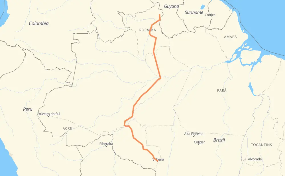
Distance between Vilhena and Tucuman
The distance from Vilhena to Tucuman is 2,557 kilometers by road. Road takes approximately 32 hours and 20 minutes and goes through Ariquemes, Porto Velho, Manaus, Pimenta Bueno, Cacoal, Presidente Médici and Ouro Preto do Oeste.
| Shortest distance by air | 1,847 km ✈️ |
| Car route length | 2,557 km 🚗 |
| Driving time | 32 h 20 min |
| Fuel amount | 204.6 L |
| Fuel cost | 401 CAD |
| Point | Distance | Time | Fuel | |
| Vilhena | 0 km | 00 min | 0.0 L | |
|
BR-364 153 km, 1 h 51 min
|
||||
| Pimenta Bueno | 153 km | 1 h 51 min | 9.4 L | |
|
BR-364 66 km, 47 min
|
||||
| Cacoal | 219 km | 2 h 39 min | 16.8 L | |
|
BR-364 89 km, 1 h 01 min
|
||||
| Presidente Médici | 307 km | 3 h 40 min | 23.3 L | |
|
BR-364 60 km, 43 min
|
||||
| Ouro Preto do Oeste | 367 km | 4 h 23 min | 28.8 L | |
|
BR-364 118 km, 2 h 00 min
|
||||
| Ariquemes | 485 km | 6 h 24 min | 36.9 L | |
|
BR-364 217 km, 2 h 37 min
|
||||
| Porto Velho | 703 km | 9 h 01 min | 56.0 L | |
|
BR-319 3 km, 02 min
|
||||
| Pedrinhas | 706 km | 9 h 03 min | 56.4 L | |
|
BR-319 879 km, 11 h 08 min
|
||||
| Manaus | 1,585 km | 20 h 12 min | 126.7 L | |
|
BR-174 972 km, 12 h 08 min
|
||||
| Tucuman | 2,557 km | 32 h 20 min | 203.9 L | |
Frequently Asked Questions
How much does it cost to drive from Vilhena to Tucuman?
Fuel cost: 401 CAD
This fuel cost is calculated as: (Route length 2,557 km / 100 km) * (Fuel consumption 8 L/100 km) * (Fuel price 1.96 CAD / L)
You can adjust fuel consumption and fuel price here.
How long is a car ride from Vilhena to Tucuman?
Driving time: 32 h 20 min
This time is calculated for driving at the maximum permitted speed, taking into account traffic rules restrictions.
- 676 km with a maximum speed 90 km/h = 7 h 30 min
- 1,746 km with a maximum speed 80 km/h = 21 h 49 min
- 20 km with a maximum speed 60 km/h = 19 min
- 101 km with a maximum speed 50 km/h = 2 h 1 min
- 3 km with a maximum speed 40 km/h = 4 min
- 12 km with a maximum speed 20 km/h = 35 min
The calculated driving time does not take into account intermediate stops and traffic jams.
How far is Vilhena to Tucuman by land?
The distance between Vilhena and Tucuman is 2,557 km by road.
Precise satellite coordinates of highways were used for this calculation. The start and finish points are the centers of Vilhena and Tucuman respectively.
How far is Vilhena to Tucuman by plane?
The shortest distance (air line, as the crow flies) between Vilhena and Tucuman is 1,847 km.
This distance is calculated using the Haversine formula as a great-circle distance between two points on the surface of a sphere. The start and finish points are the centers of Vilhena and Tucuman respectively. Actual distance between airports may be different.
How many hours is Vilhena from Tucuman by plane?
Boeing 737 airliner needs 2 h 18 min to cover the distance of 1,847 km at a cruising speed of 800 km/h.
Small plane "Cessna 172" needs 8 h 23 min to flight this distance at average speed of 220 km/h.
This time is approximate and do not take into account takeoff and landing times, airport location and other real world factors.
How long is a helicopter ride from Vilhena to Tucuman?
Fast helicopter "Eurocopter AS350" or "Hughes OH-6 Cayuse" need 7 h 41 min to cover the distance of 1,847 km at a cruising speed of 240 km/h.
Popular "Robinson R44" needs 8 h 47 min to flight this distance at average speed of 210 km/h.
This time is approximate and do not take into account takeoff and landing times, aerodrome location and other real world factors.
What city is halfway between Vilhena and Tucuman?
The halfway point between Vilhena and Tucuman is Igapó Açu. It is located about 55 km from the exact midpoint by road.
The distance from Igapó Açu to Vilhena is 1,334 km and driving will take about 16 h 54 min. The road between Igapó Açu and Tucuman has length 1,224 km and will take approximately 15 h 26 min.
The other cities located close to halfway point:
Where is Vilhena in relation to Tucuman?
Vilhena is located 1,847 km south of Tucuman.
Vilhena has geographic coordinates: latitude -12.73685, longitude -60.14656.
Tucuman has geographic coordinates: latitude 3.86854, longitude -59.89866.
Which highway goes from Vilhena to Tucuman?
The route from Vilhena to Tucuman follows BR-319, BR-174, BR-364, BR-401, BR-210.
Other minor sections pass along the road:
- BR-230: 23 km
- BR-433: 11 km