Distance between Vancouver BC and Silver Valley BC
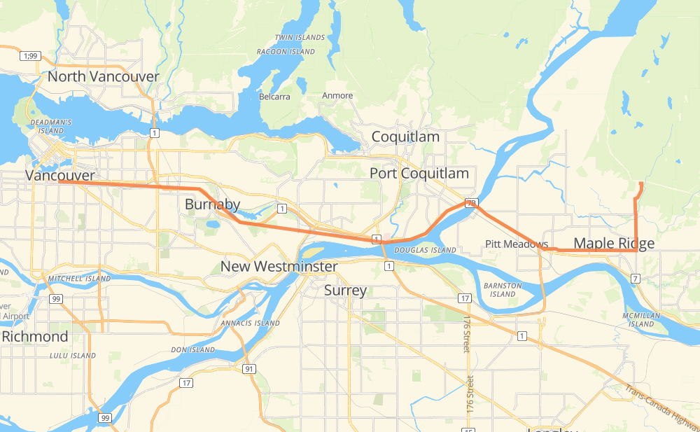
The distance from Vancouver to Silver Valley is 49 kilometers by road including 15 kilometers on motorways. Road takes approximately 40 minutes and goes through Burnaby, Coquitlam, Port Coquitlam, Pitt Meadows, Maple Ridge and Haney.
| Shortest distance by air | 39 km ✈️ |
| Car route length | 49 km 🚗 |
| Driving time | 40 min |
| Fuel amount | 3.9 L |
| Fuel cost | 7.6 CAD |
| Point | Distance | Time | Fuel | |
| Vancouver | 0 km | 00 min | 0.0 L | |
|
13 km, 12 min
|
||||
| Burnaby | 13 km | 12 min | 0.6 L | |
|
1 9 km, 06 min
|
||||
| Coquitlam | 22 km | 18 min | 1.5 L | |
|
1 7 km, 05 min
|
||||
| Port Coquitlam | 29 km | 23 min | 2.0 L | |
|
7B 6 km, 05 min
|
||||
| Pitt Meadows | 35 km | 29 min | 2.6 L | |
|
7 14 km, 11 min
|
||||
| Maple Ridge | 49 km | 40 min | 3.0 L | |
Frequently Asked Questions
How much does it cost to drive from Vancouver to Silver Valley?
Fuel cost: 7.6 CAD
This fuel cost is calculated as: (Route length 49 km / 100 km) * (Fuel consumption 8 L/100 km) * (Fuel price 1.97 CAD / L)
You can adjust fuel consumption and fuel price here.
How long is a car ride from Vancouver to Silver Valley?
Driving time: 40 min
This time is calculated for driving at the maximum permitted speed, taking into account traffic rules restrictions.
- 13 km with a maximum speed 90 km/h = 8 min
- 19 km with a maximum speed 80 km/h = 14 min
- 4 km with a maximum speed 70 km/h = 3 min
- 4 km with a maximum speed 60 km/h = 4 min
- 9 km with a maximum speed 50 km/h = 10 min
The calculated driving time does not take into account intermediate stops and traffic jams.
How far is Vancouver to Silver Valley by land?
The distance between Vancouver and Silver Valley is 49 km by road including 15 km on motorways.
Precise satellite coordinates of highways were used for this calculation. The start and finish points are the centers of Vancouver and Silver Valley respectively.
How far is Vancouver to Silver Valley by plane?
The shortest distance (air line, as the crow flies) between Vancouver and Silver Valley is 39 km.
This distance is calculated using the Haversine formula as a great-circle distance between two points on the surface of a sphere. The start and finish points are the centers of Vancouver and Silver Valley respectively. Actual distance between airports may be different.
How many hours is Vancouver from Silver Valley by plane?
Boeing 737 airliner needs 2 min to cover the distance of 39 km at a cruising speed of 800 km/h.
Small plane "Cessna 172" needs 10 min to flight this distance at average speed of 220 km/h.
This time is approximate and do not take into account takeoff and landing times, airport location and other real world factors.
How long is a helicopter ride from Vancouver to Silver Valley?
Fast helicopter "Eurocopter AS350" or "Hughes OH-6 Cayuse" need 9 min to cover the distance of 39 km at a cruising speed of 240 km/h.
Popular "Robinson R44" needs 11 min to flight this distance at average speed of 210 km/h.
This time is approximate and do not take into account takeoff and landing times, aerodrome location and other real world factors.
What city is halfway between Vancouver and Silver Valley?
The halfway point between Vancouver and Silver Valley is Coquitlam. It is located about 3 km from the exact midpoint by road.
The distance from Coquitlam to Vancouver is 22 km and driving will take about 18 min. The road between Coquitlam and Silver Valley has length 27 km and will take approximately 22 min.
The other cities located close to halfway point:
Where is Vancouver in relation to Silver Valley?
Vancouver is located 39 km west of Silver Valley.
Vancouver has geographic coordinates: latitude 49.26243, longitude -123.11554.
Silver Valley has geographic coordinates: latitude 49.26005, longitude -122.57726.
Which highway goes from Vancouver to Silver Valley?
The route from Vancouver to Silver Valley follows 1.
Other minor sections pass along the road:
- 7B: 9 km
- 7: 6 km