Distance between Van Horn TX and Baton Rouge LA
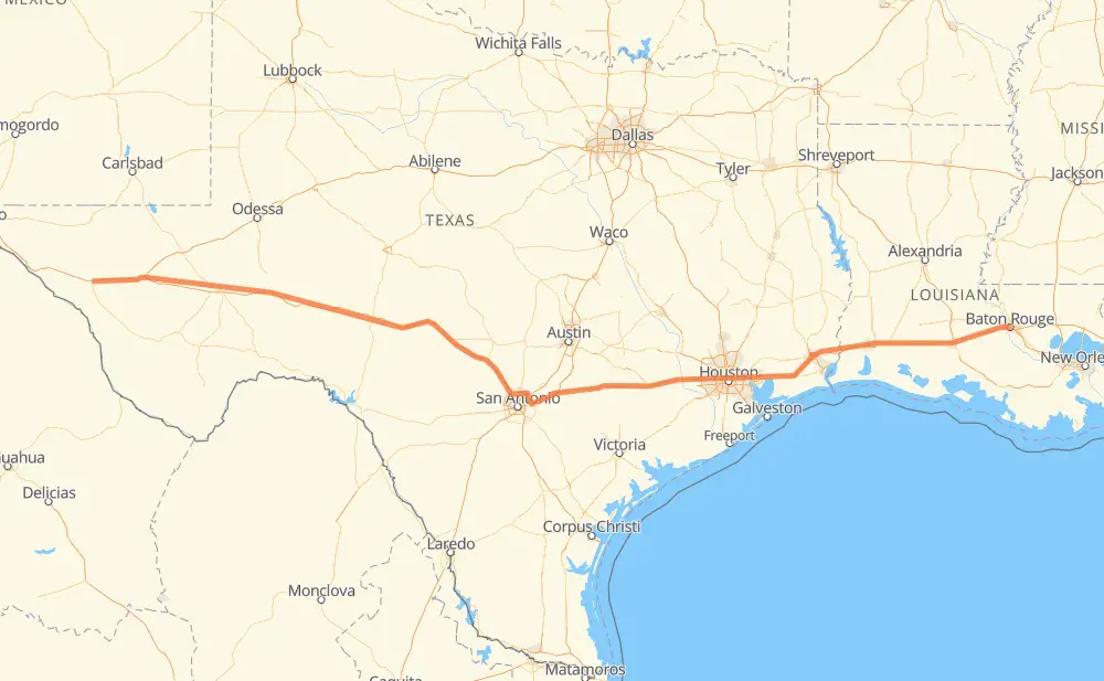
The distance from Van Horn to Baton Rouge is 1,437 kilometers by road including 1,422 kilometers on motorways. Road takes approximately 13 hours and 40 minutes and goes through Houston, Beaumont, Lake Charles, Fort Stockton, Kerrville, Comfort and Boerne.
| Shortest distance by air | 1,308 km ✈️ |
| Car route length | 1,437 km 🚗 |
| Driving time | 13 h 40 min |
| Fuel amount | 114.9 L |
| Fuel cost | 220.7 CAD |
| Point | Distance | Time | Fuel | |
| Van Horn | 0 km | 00 min | 0.0 L | |
|
I 10 191 km, 1 h 50 min
|
||||
| Fort Stockton | 191 km | 1 h 50 min | 14.0 L | |
|
I 10 406 km, 3 h 50 min
|
||||
| Kerrville | 597 km | 5 h 41 min | 47.3 L | |
|
I 10 20 km, 10 min
|
||||
| Comfort | 617 km | 5 h 52 min | 49.0 L | |
|
I 10 25 km, 14 min
|
||||
| Boerne | 642 km | 6 h 06 min | 50.6 L | |
|
I 10 Loop 1604 87 km, 49 min
|
||||
| Cibolo | 729 km | 6 h 55 min | 57.8 L | |
|
I 10 274 km, 2 h 33 min
|
||||
| Houston | 1,003 km | 9 h 28 min | 79.8 L | |
|
I 10 138 km, 1 h 19 min
|
||||
| Beaumont | 1,141 km | 10 h 48 min | 90.9 L | |
|
I 10 92 km, 51 min
|
||||
| Lake Charles | 1,233 km | 11 h 40 min | 98.2 L | |
|
I 10 204 km, 1 h 59 min
|
||||
| Baton Rouge | 1,437 km | 13 h 40 min | 114.4 L | |
Hotels of Baton Rouge
Frequently Asked Questions
How much does it cost to drive from Van Horn to Baton Rouge?
Fuel cost: 220.7 CAD
This fuel cost is calculated as: (Route length 1,437 km / 100 km) * (Fuel consumption 8 L/100 km) * (Fuel price 1.92 CAD / L)
You can adjust fuel consumption and fuel price here.
How long is a car ride from Van Horn to Baton Rouge?
Driving time: 13 h 40 min
This time is calculated for driving at the maximum permitted speed, taking into account traffic rules restrictions.
- 886 km with a maximum speed 110 km/h = 8 h 3 min
- 120 km with a maximum speed 105 km/h = 1 h 8 min
- 280 km with a maximum speed 100 km/h = 2 h 47 min
- 90 km with a maximum speed 97 km/h = 56 min
- 11 km with a maximum speed 90 km/h = 7 min
- 3 km with a maximum speed 80 km/h = 1 min
- 44 km with a maximum speed 80 km/h = 33 min
The calculated driving time does not take into account intermediate stops and traffic jams.
How far is Van Horn to Baton Rouge by land?
The distance between Van Horn and Baton Rouge is 1,437 km by road including 1,422 km on motorways.
Precise satellite coordinates of highways were used for this calculation. The start and finish points are the centers of Van Horn and Baton Rouge respectively.
How far is Van Horn to Baton Rouge by plane?
The shortest distance (air line, as the crow flies) between Van Horn and Baton Rouge is 1,308 km.
This distance is calculated using the Haversine formula as a great-circle distance between two points on the surface of a sphere. The start and finish points are the centers of Van Horn and Baton Rouge respectively. Actual distance between airports may be different.
How many hours is Van Horn from Baton Rouge by plane?
Boeing 737 airliner needs 1 h 38 min to cover the distance of 1,308 km at a cruising speed of 800 km/h.
Small plane "Cessna 172" needs 5 h 56 min to flight this distance at average speed of 220 km/h.
This time is approximate and do not take into account takeoff and landing times, airport location and other real world factors.
How long is a helicopter ride from Van Horn to Baton Rouge?
Fast helicopter "Eurocopter AS350" or "Hughes OH-6 Cayuse" need 5 h 27 min to cover the distance of 1,308 km at a cruising speed of 240 km/h.
Popular "Robinson R44" needs 6 h 13 min to flight this distance at average speed of 210 km/h.
This time is approximate and do not take into account takeoff and landing times, aerodrome location and other real world factors.
What city is halfway between Van Horn and Baton Rouge?
The halfway point between Van Horn and Baton Rouge is Friendly Corner. It is located about 3 km from the exact midpoint by road.
The distance from Friendly Corner to Van Horn is 722 km and driving will take about 6 h 51 min. The road between Friendly Corner and Baton Rouge has length 715 km and will take approximately 6 h 48 min.
The other cities located close to halfway point:
Where is Van Horn in relation to Baton Rouge?
Van Horn is located 1,308 km west of Baton Rouge.
Van Horn has geographic coordinates: latitude 31.03801, longitude -104.83037.
Baton Rouge has geographic coordinates: latitude 30.45075, longitude -91.15455.
Which highway goes from Van Horn to Baton Rouge?
The route from Van Horn to Baton Rouge follows I 10, US 90.
Other minor sections pass along the road:
- US 87: 53 km
- TX 130: 43 km
- Loop 1604: 41 km
- US 67: 38 km
- US 385: 18 km
- I 10 Toll: 17 km
- US 83: 9 km
- US 69: 4 km
- US 96: 4 km
- US 287: 4 km
- TX 17: 3 km
- US 61 Business: 2 km
- US 190 Business: 2 km
- TX 71: 2 km