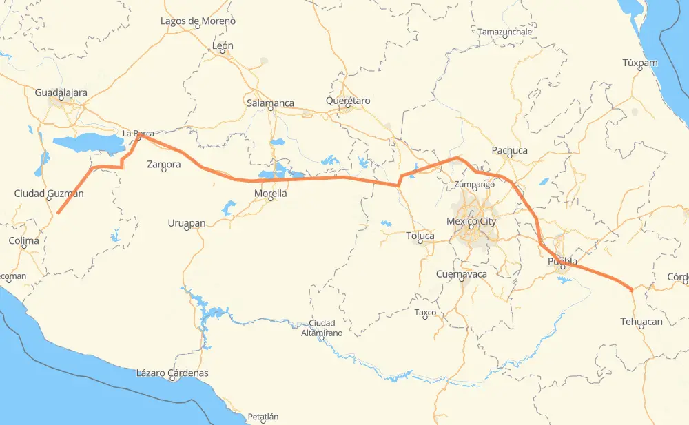
Distance between Tuxpan and Cuacnopalan
The distance from Tuxpan to Cuacnopalan is 810 kilometers by road including 645 kilometers on motorways. Road takes approximately 8 hours and 58 minutes and goes through Mazamitla, San José de Gracia, Jiquilpan de Juárez, Sahuayo de Morelos, San Pedro Cahro, La Barca and Vista Hermosa de Negrete.
| Shortest distance by air | 621 km ✈️ |
| Car route length | 810 km 🚗 |
| Driving time | 8 h 58 min |
| Fuel amount | 64.8 L |
| Fuel cost | 126.9 CAD |
| Toll roads cost | 436 + ? MXN |
| Point | Distance | Time | Fuel | |
| Tuxpan | 0 km | 00 min | 0.0 L | |
|
MEX 110 72 km, 50 min
|
||||
| Mazamitla | 72 km | 50 min | 5.5 L | |
|
JAL 414 17 km, 12 min
|
||||
| San José de Gracia | 89 km | 1 h 02 min | 6.1 L | |
|
MEX 110 29 km, 21 min
|
||||
| Jiquilpan de Juárez | 118 km | 1 h 24 min | 9.2 L | |
|
MEX 110 8 km, 05 min
|
||||
| Sahuayo de Morelos | 126 km | 1 h 30 min | 9.7 L | |
|
MEX 110 13 km, 09 min
|
||||
| San Pedro Cahro | 139 km | 1 h 40 min | 10.6 L | |
|
MEX 110 22 km, 16 min
|
||||
| La Barca | 161 km | 1 h 56 min | 12.7 L | |
|
MEX 71 MEX 15D 16 km, 11 min
|
||||
| Vista Hermosa de Negrete | 177 km | 2 h 07 min | 13.8 L | |
|
MEX 15D 28 km, 18 min
|
||||
| Ecuandureo | 205 km | 2 h 25 min | 16.1 L | |
|
MEX 15D 608 km, 6 h 32 min
|
||||
| Cuacnopalan | 813 km | 8 h 58 min | 63.6 L | |
Frequently Asked Questions
How many toll booths are there from Tuxpan to Cuacnopalan?
There are 10 toll booths between Tuxpan and Cuacnopalan: Zinapecuaro, Contepec, Panindicuaro, Ecuandureo, Atlacomulco — Maravatio, Atlacomulco 2, San Martin Texmelucan, San Martín, Viaducto Elevado de Puebla and Amozoc.
How much does the toll booths cost from Tuxpan to Cuacnopalan?
Toll roads cost: Ecuandureo (111 MXN) + Panindicuaro (?) + Zinapecuaro (161 MXN) + Contepec (?) + Atlacomulco — Maravatio (50 MXN) + Atlacomulco 2 (?) + San Martin Texmelucan (?) + San Martín (42 MXN) + Viaducto Elevado de Puebla (?) + Amozoc (72 MXN) = 436 + ? MXN
How much does it cost to drive from Tuxpan to Cuacnopalan?
Fuel cost: 126.9 CAD
This fuel cost is calculated as: (Route length 810 km / 100 km) * (Fuel consumption 8 L/100 km) * (Fuel price 1.96 CAD / L)
You can adjust fuel consumption and fuel price here.
Toll roads cost: 436 + ? MXN
How long is a car ride from Tuxpan to Cuacnopalan?
Driving time: 8 h 58 min
This time is calculated for driving at the maximum permitted speed, taking into account traffic rules restrictions.
- 68 km with a maximum speed 110 km/h = 36 min
- 355 km with a maximum speed 100 km/h = 3 h 33 min
- 76 km with a maximum speed 90 km/h = 50 min
- 306 km with a maximum speed 80 km/h = 3 h 49 min
- 5 km with a maximum speed 70 km/h = 3 min
- 4 km with a maximum speed 50 km/h = 4 min
The calculated driving time does not take into account intermediate stops and traffic jams.
How far is Tuxpan to Cuacnopalan by land?
The distance between Tuxpan and Cuacnopalan is 810 km by road including 645 km on motorways.
Precise satellite coordinates of highways were used for this calculation. The start and finish points are the centers of Tuxpan and Cuacnopalan respectively.
How far is Tuxpan to Cuacnopalan by plane?
The shortest distance (air line, as the crow flies) between Tuxpan and Cuacnopalan is 621 km.
This distance is calculated using the Haversine formula as a great-circle distance between two points on the surface of a sphere. The start and finish points are the centers of Tuxpan and Cuacnopalan respectively. Actual distance between airports may be different.
How many hours is Tuxpan from Cuacnopalan by plane?
Boeing 737 airliner needs 46 min to cover the distance of 621 km at a cruising speed of 800 km/h.
Small plane "Cessna 172" needs 2 h 49 min to flight this distance at average speed of 220 km/h.
This time is approximate and do not take into account takeoff and landing times, airport location and other real world factors.
How long is a helicopter ride from Tuxpan to Cuacnopalan?
Fast helicopter "Eurocopter AS350" or "Hughes OH-6 Cayuse" need 2 h 35 min to cover the distance of 621 km at a cruising speed of 240 km/h.
Popular "Robinson R44" needs 2 h 57 min to flight this distance at average speed of 210 km/h.
This time is approximate and do not take into account takeoff and landing times, aerodrome location and other real world factors.
What city is halfway between Tuxpan and Cuacnopalan?
The halfway point between Tuxpan and Cuacnopalan is Maravatio. It is located about 4 km from the exact midpoint by road.
The distance from Maravatio to Tuxpan is 401 km and driving will take about 4 h 29 min. The road between Maravatio and Cuacnopalan has length 409 km and will take approximately 4 h 28 min.
The other cities located close to halfway point:
Where is Tuxpan in relation to Cuacnopalan?
Tuxpan is located 621 km west of Cuacnopalan.
Tuxpan has geographic coordinates: latitude 19.55634, longitude -103.37599.
Cuacnopalan has geographic coordinates: latitude 18.81889, longitude -97.51111.
Which highway goes from Tuxpan to Cuacnopalan?
The route from Tuxpan to Cuacnopalan follows MEX 15D, MEX M40D, MEX 110, MEX 150D.
Other minor sections pass along the road:
- MEX 15: 9 km
- MEX 040D: 7 km
- MEX 71: 6 km
- JAL 414: 4 km
- MEX 35: 3 km
- MICH 110: 2 km
- MEX 135D: 1 km