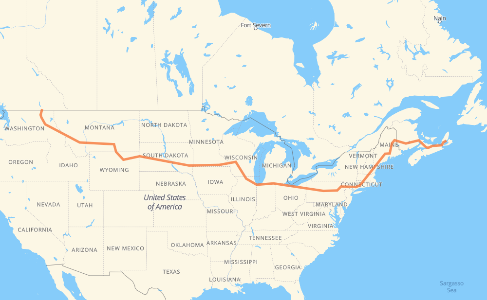
Distance between Trail BC and Baddeck NS
The distance from Trail to Baddeck is 5,980 kilometers by road including 5,664 kilometers on motorways. Road takes approximately 57 hours and 12 minutes and goes through Spokane, Coeur d'Alene, Missoula, Butte, Billings, Sheridan and Gillette.
| Shortest distance by air | 4,183 km ✈️ |
| Car route length | 5,980 km 🚗 |
| Driving time | 57 h 12 min |
| Fuel amount | 478.4 L |
| Fuel cost | 942.5 CAD |
| Point | Distance | Time | Fuel | |
| Trail | 0 km | 00 min | 0.0 L | |
|
3B US 395 200 km, 2 h 32 min
|
||||
| Spokane | 200 km | 2 h 32 min | 16.0 L | |
|
I 90 51 km, 33 min
|
||||
| Coeur d'Alene | 251 km | 3 h 05 min | 19.6 L | |
|
I 90 265 km, 2 h 27 min
|
||||
| Missoula | 516 km | 5 h 33 min | 41.0 L | |
|
I 90 184 km, 1 h 40 min
|
||||
| Butte | 700 km | 7 h 13 min | 54.1 L | |
|
I 90 364 km, 3 h 24 min
|
||||
| Billings | 1,064 km | 10 h 37 min | 84.5 L | |
|
I 90 216 km, 2 h 15 min
|
||||
| Sheridan | 1,280 km | 12 h 53 min | 101.5 L | |
|
I 90 160 km, 1 h 27 min
|
||||
| Gillette | 1,440 km | 14 h 21 min | 114.7 L | |
|
I 90 156 km, 1 h 29 min
|
||||
| Spearfish | 1,596 km | 15 h 50 min | 126.8 L | |
|
I 90 68 km, 37 min
|
||||
| Rapid City | 1,664 km | 16 h 27 min | 132.8 L | |
|
I 90 18 km, 10 min
|
||||
| Box Elder | 1,682 km | 16 h 37 min | 133.8 L | |
|
I 90 411 km, 3 h 44 min
|
||||
| Mitchell | 2,093 km | 20 h 22 min | 166.3 L | |
|
I 90 116 km, 1 h 03 min
|
||||
| Sioux Falls | 2,210 km | 21 h 25 min | 176.5 L | |
|
I 90 11 km, 06 min
|
||||
| Brandon | 2,221 km | 21 h 31 min | 177.4 L | |
|
I 90 676 km, 6 h 11 min
|
||||
| Madison | 2,897 km | 27 h 43 min | 231.0 L | |
|
I 39 56 km, 30 min
|
||||
| Janesville | 2,953 km | 28 h 14 min | 235.9 L | |
|
I 39 I 90 173 km, 1 h 39 min
|
||||
| Chicago | 3,126 km | 29 h 53 min | 248.2 L | |
|
I 90 139 km, 1 h 22 min
|
||||
| South Bend | 3,266 km | 31 h 16 min | 260.7 L | |
|
I 80 369 km, 3 h 21 min
|
||||
| Elyria | 3,634 km | 34 h 37 min | 290.3 L | |
|
I 80 618 km, 5 h 42 min
|
||||
| Scranton | 4,252 km | 40 h 20 min | 339.9 L | |
|
I 81 I 84 262 km, 2 h 34 min
|
||||
| Waterbury | 4,514 km | 42 h 55 min | 360.6 L | |
|
I 84 43 km, 27 min
|
||||
| Hartford | 4,557 km | 43 h 22 min | 364.3 L | |
|
I 84 103 km, 1 h 03 min
|
||||
| Worcester | 4,660 km | 44 h 26 min | 372.4 L | |
|
I 290 I 495 65 km, 38 min
|
||||
| Lowell | 4,725 km | 45 h 04 min | 377.9 L | |
|
I 495 I 95 154 km, 1 h 29 min
|
||||
| Portland | 4,879 km | 46 h 34 min | 390.1 L | |
|
I 295 88 km, 52 min
|
||||
| Augusta | 4,967 km | 47 h 26 min | 397.0 L | |
|
I 95 21 km, 11 min
|
||||
| Waterville | 4,988 km | 47 h 38 min | 397.8 L | |
|
I 95 101 km, 55 min
|
||||
| Bangor | 5,089 km | 48 h 34 min | 406.2 L | |
|
I 95 304 km, 2 h 56 min
|
||||
| Fredericton | 5,393 km | 51 h 30 min | 431.1 L | |
|
2 170 km, 1 h 32 min
|
||||
| Moncton | 5,563 km | 53 h 03 min | 444.3 L | |
|
2 TCH 417 km, 4 h 08 min
|
||||
| Baddeck | 5,980 km | 57 h 11 min | 477.7 L | |
Hotels of Baddeck
Frequently Asked Questions
How much does it cost to drive from Trail to Baddeck?
Fuel cost: 942.5 CAD
This fuel cost is calculated as: (Route length 5,980 km / 100 km) * (Fuel consumption 8 L/100 km) * (Fuel price 1.97 CAD / L)
You can adjust fuel consumption and fuel price here.
How long is a car ride from Trail to Baddeck?
Driving time: 57 h 12 min
This time is calculated for driving at the maximum permitted speed, taking into account traffic rules restrictions.
- 4,295 km with a maximum speed 110 km/h = 39 h 2 min
- 615 km with a maximum speed 105 km/h = 5 h 52 min
- 337 km with a maximum speed 100 km/h = 3 h 22 min
- 75 km with a maximum speed 97 km/h = 46 min
- 144 km with a maximum speed 90 km/h = 1 h 35 min
- 113 km with a maximum speed 89 km/h = 1 h 16 min
- 17 km with a maximum speed 80 km/h = 12 min
- 331 km with a maximum speed 80 km/h = 4 h 8 min
- 22 km with a maximum speed 72 km/h = 17 min
- 5 km with a maximum speed 70 km/h = 4 min
- 1 km with a maximum speed 64 km/h = 1 min
- 8 km with a maximum speed 56 km/h = 8 min
- 14 km with a maximum speed 50 km/h = 16 min
- 2 km with a maximum speed 48 km/h = 2 min
The calculated driving time does not take into account intermediate stops and traffic jams.
How far is Trail to Baddeck by land?
The distance between Trail and Baddeck is 5,980 km by road including 5,664 km on motorways.
Precise satellite coordinates of highways were used for this calculation. The start and finish points are the centers of Trail and Baddeck respectively.
How far is Trail to Baddeck by plane?
The shortest distance (air line, as the crow flies) between Trail and Baddeck is 4,183 km.
This distance is calculated using the Haversine formula as a great-circle distance between two points on the surface of a sphere. The start and finish points are the centers of Trail and Baddeck respectively. Actual distance between airports may be different.
How many hours is Trail from Baddeck by plane?
Boeing 737 airliner needs 5 h 13 min to cover the distance of 4,183 km at a cruising speed of 800 km/h.
Small plane "Cessna 172" needs 19 h to flight this distance at average speed of 220 km/h.
This time is approximate and do not take into account takeoff and landing times, airport location and other real world factors.
How long is a helicopter ride from Trail to Baddeck?
Fast helicopter "Eurocopter AS350" or "Hughes OH-6 Cayuse" need 17 h 25 min to cover the distance of 4,183 km at a cruising speed of 240 km/h.
Popular "Robinson R44" needs 19 h 55 min to flight this distance at average speed of 210 km/h.
This time is approximate and do not take into account takeoff and landing times, aerodrome location and other real world factors.
What city is halfway between Trail and Baddeck?
The halfway point between Trail and Baddeck is Machesney Park. It is located about 2 km from the exact midpoint by road.
The distance from Machesney Park to Trail is 2,988 km and driving will take about 28 h 31 min. The road between Machesney Park and Baddeck has length 2,992 km and will take approximately 28 h 41 min.
The other cities located close to halfway point:
Where is Trail in relation to Baddeck?
Trail is located 4,183 km west of Baddeck.
Trail has geographic coordinates: latitude 49.09905, longitude -117.71301.
Baddeck has geographic coordinates: latitude 46.09968, longitude -60.75355.
Which highway goes from Trail to Baddeck?
The route from Trail to Baddeck follows I 90, I 80, I 95, I 84, TCH, 2, US 14, NS 104, US 87, I 94, I 39, US 212, US 12, US 395.
Other minor sections pass along the road:
- US 191: 92 km
- I 495: 89 km
- I 295: 85 km
- NS 105: 83 km
- I 81: 56 km
- SD 79: 50 km
- US 16: 40 km
- US 6: 38 km
- WA 25: 36 km
- I 290: 32 km
- US 51: 32 km
- US 83: 31 km
- US 220: 28 km
- MT 200: 21 km
- 22: 20 km
- 95: 14 km
- I 15: 12 km
- US 85: 11 km
- NY 52: 11 km
- US 89: 11 km
- 7: 11 km
- SD 63: 11 km
- SD 73: 10 km
- 3B: 10 km
- SD 50: 10 km
- SD 34: 9 km
- US 395 Fut: 9 km
- PA 309: 8 km
- US 93: 8 km
- SD 45: 7 km
- US 61: 7 km
- SR 11: 6 km
- PA 66: 6 km
- US 1: 6 km
- US 16 Truck: 6 km
- US 7: 6 km
- I 380: 6 km
- US 202: 5 km
- 105: 5 km
- US 220 Alternate: 4 km
- NS 4: 4 km
- ME 15: 4 km
- MN 43: 4 km
- US 218: 4 km
- PA 28 Truck: 4 km
- WI 11: 3 km
- WA 20: 3 km
- 205: 2 km
- SD 37: 2 km
- US 53: 2 km