Distance between Tracy QC and View Royal BC
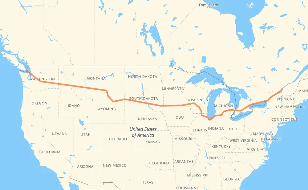
The distance from Tracy to View Royal is 4,996 kilometers by road including 4,796 kilometers on motorways. Road takes approximately 49 hours and 31 minutes and goes through Longueuil, Montreal, Cornwall, Brockville, Kingston, Belleville and Oshawa.
| Shortest distance by air | 3,738 km ✈️ |
| Car route length | 4,996 km 🚗 |
| Driving time | 49 h 31 min |
| Fuel amount | 399.7 L |
| Fuel cost | 783.4 CAD |
| Point | Distance | Time | Fuel | |
| Tracy | 0 km | 00 min | 0.0 L | |
|
30 61 km, 39 min
|
||||
| Longueuil | 61 km | 39 min | 4.8 L | |
|
25 16 km, 12 min
|
||||
| Montreal | 77 km | 51 min | 5.0 L | |
|
40 401 109 km, 1 h 09 min
|
||||
| Cornwall | 186 km | 2 h 00 min | 14.6 L | |
|
401 92 km, 55 min
|
||||
| Brockville | 278 km | 2 h 56 min | 21.7 L | |
|
401 79 km, 47 min
|
||||
| Kingston | 357 km | 3 h 43 min | 27.0 L | |
|
401 77 km, 45 min
|
||||
| Belleville | 433 km | 4 h 29 min | 33.7 L | |
|
401 126 km, 1 h 15 min
|
||||
| Oshawa | 559 km | 5 h 44 min | 44.3 L | |
|
401 15 km, 08 min
|
||||
| Ajax | 573 km | 5 h 53 min | 45.6 L | |
|
401 32 km, 19 min
|
||||
| Toronto | 605 km | 6 h 12 min | 46.7 L | |
|
401 31 km, 18 min
|
||||
| Mississauga | 636 km | 6 h 30 min | 50.1 L | |
|
401 66 km, 39 min
|
||||
| Kitchener | 702 km | 7 h 10 min | 55.9 L | |
|
401 42 km, 25 min
|
||||
| Woodstock | 744 km | 7 h 35 min | 59.1 L | |
|
401 402 140 km, 1 h 19 min
|
||||
| Sarnia | 884 km | 8 h 55 min | 70.0 L | |
|
402 I 69 122 km, 1 h 12 min
|
||||
| Flint | 1,006 km | 10 h 07 min | 80.1 L | |
|
I 69 99 km, 53 min
|
||||
| Lansing | 1,105 km | 11 h 01 min | 88.2 L | |
|
I 69 102 km, 55 min
|
||||
| Kalamazoo | 1,206 km | 11 h 57 min | 96.3 L | |
|
I 94 I 90 409 km, 3 h 53 min
|
||||
| Janesville | 1,616 km | 15 h 50 min | 128.9 L | |
|
I 39 56 km, 30 min
|
||||
| Madison | 1,672 km | 16 h 21 min | 133.0 L | |
|
I 39 I 90 677 km, 6 h 09 min
|
||||
| Brandon | 2,349 km | 22 h 31 min | 187.6 L | |
|
I 90 11 km, 06 min
|
||||
| Sioux Falls | 2,360 km | 22 h 37 min | 188.4 L | |
|
I 90 116 km, 1 h 03 min
|
||||
| Mitchell | 2,476 km | 23 h 40 min | 196.9 L | |
|
I 90 411 km, 3 h 44 min
|
||||
| Box Elder | 2,887 km | 27 h 25 min | 230.2 L | |
|
I 90 19 km, 10 min
|
||||
| Rapid City | 2,906 km | 27 h 35 min | 232.1 L | |
|
I 90 68 km, 36 min
|
||||
| Spearfish | 2,973 km | 28 h 12 min | 237.0 L | |
|
I 90 156 km, 1 h 29 min
|
||||
| Gillette | 3,129 km | 29 h 42 min | 249.8 L | |
|
I 90 160 km, 1 h 34 min
|
||||
| Sheridan | 3,289 km | 31 h 16 min | 262.2 L | |
|
I 90 216 km, 2 h 02 min
|
||||
| Billings | 3,505 km | 33 h 19 min | 279.8 L | |
|
I 90 363 km, 3 h 19 min
|
||||
| Butte | 3,869 km | 36 h 39 min | 307.6 L | |
|
I 90 185 km, 1 h 40 min
|
||||
| Missoula | 4,053 km | 38 h 20 min | 324.0 L | |
|
I 90 265 km, 2 h 27 min
|
||||
| Coeur d'Alene | 4,319 km | 40 h 48 min | 345.0 L | |
|
I 90 55 km, 31 min
|
||||
| Spokane | 4,373 km | 41 h 19 min | 349.1 L | |
|
I 90 179 km, 1 h 37 min
|
||||
| Moses Lake | 4,552 km | 42 h 57 min | 362.2 L | |
|
I 90 250 km, 2 h 18 min
|
||||
| Bellevue | 4,802 km | 45 h 15 min | 383.9 L | |
|
I 90 20 km, 12 min
|
||||
| Seattle | 4,822 km | 45 h 28 min | 384.9 L | |
|
I 5 US 101 128 km, 1 h 57 min
|
||||
| Port Angeles | 4,950 km | 47 h 26 min | 395.8 L | |
|
US 101 42 km, 1 h 58 min
|
||||
| Victoria | 4,992 km | 49 h 24 min | 399.1 L | |
|
1 6 km, 07 min
|
||||
| View Royal | 4,998 km | 49 h 31 min | 399.8 L | |
Frequently Asked Questions
How much does it cost to drive from Tracy to View Royal?
Fuel cost: 783.4 CAD
This fuel cost is calculated as: (Route length 4,996 km / 100 km) * (Fuel consumption 8 L/100 km) * (Fuel price 1.96 CAD / L)
You can adjust fuel consumption and fuel price here.
How long is a car ride from Tracy to View Royal?
Driving time: 49 h 31 min
This time is calculated for driving at the maximum permitted speed, taking into account traffic rules restrictions.
- 3,408 km with a maximum speed 110 km/h = 30 h 58 min
- 186 km with a maximum speed 105 km/h = 1 h 46 min
- 1,012 km with a maximum speed 100 km/h = 10 h 7 min
- 77 km with a maximum speed 97 km/h = 47 min
- 30 km with a maximum speed 90 km/h = 20 min
- 65 km with a maximum speed 89 km/h = 43 min
- 7 km with a maximum speed 80 km/h = 4 min
- 86 km with a maximum speed 80 km/h = 1 h 4 min
- 17 km with a maximum speed 72 km/h = 14 min
- 24 km with a maximum speed 70 km/h = 20 min
- 3 km with a maximum speed 65 km/h = 2 min
- 9 km with a maximum speed 64 km/h = 8 min
- 9 km with a maximum speed 56 km/h = 9 min
- 9 km with a maximum speed 50 km/h = 11 min
- 1 km with a maximum speed 48 km/h = 1 min
- 3 km with a maximum speed 40 km/h = 4 min
- 2 km with a maximum speed 40 km/h = 2 min
- 47 km with a maximum speed 20 km/h = 2 h 19 min
The calculated driving time does not take into account intermediate stops and traffic jams.
How far is Tracy to View Royal by land?
The distance between Tracy and View Royal is 4,996 km by road including 4,796 km on motorways.
Precise satellite coordinates of highways were used for this calculation. The start and finish points are the centers of Tracy and View Royal respectively.
How far is Tracy to View Royal by plane?
The shortest distance (air line, as the crow flies) between Tracy and View Royal is 3,738 km.
This distance is calculated using the Haversine formula as a great-circle distance between two points on the surface of a sphere. The start and finish points are the centers of Tracy and View Royal respectively. Actual distance between airports may be different.
How many hours is Tracy from View Royal by plane?
Boeing 737 airliner needs 4 h 40 min to cover the distance of 3,738 km at a cruising speed of 800 km/h.
Small plane "Cessna 172" needs 16 h 59 min to flight this distance at average speed of 220 km/h.
This time is approximate and do not take into account takeoff and landing times, airport location and other real world factors.
How long is a helicopter ride from Tracy to View Royal?
Fast helicopter "Eurocopter AS350" or "Hughes OH-6 Cayuse" need 15 h 34 min to cover the distance of 3,738 km at a cruising speed of 240 km/h.
Popular "Robinson R44" needs 17 h 48 min to flight this distance at average speed of 210 km/h.
This time is approximate and do not take into account takeoff and landing times, aerodrome location and other real world factors.
What city is halfway between Tracy and View Royal?
The halfway point between Tracy and View Royal is Mitchell. It is located about 22 km from the exact midpoint by road.
The distance from Mitchell to Tracy is 2,476 km and driving will take about 23 h 39 min. The road between Mitchell and View Royal has length 2,520 km and will take approximately 25 h 52 min.
The other cities located close to halfway point:
Where is Tracy in relation to View Royal?
Tracy is located 3,738 km east of View Royal.
Tracy has geographic coordinates: latitude 46.02254, longitude -73.14731.
View Royal has geographic coordinates: latitude 48.45198, longitude -123.43552.
Which highway goes from Tracy to View Royal?
The route from Tracy to View Royal follows I 90, 401, I 94, US 14, I 69, US 87, I 39, US 212, US 12, 402.
Other minor sections pass along the road:
- US 395: 95 km
- US 191: 92 km
- US 101: 56 km
- SD 79: 50 km
- 40: 47 km
- WA 104: 46 km
- 30: 44 km
- US 16: 40 km
- US 83: 31 km
- US 51: 30 km
- 20: 28 km
- US 41: 22 km
- MT 200: 22 km
- I 5: 16 km
- I 15: 12 km
- US 85: 12 km
- US 89: 11 km
- 132: 11 km
- SD 63: 11 km
- SD 73: 10 km
- SD 50: 10 km
- SD 34: 10 km
- US 93: 8 km
- I 96: 8 km
- SD 45: 7 km
- 25: 7 km
- US 61: 7 km
- US 16 Truck: 6 km
- US 97: 6 km
- US 31: 5 km
- US 2: 4 km
- MN 43: 4 km
- US 218: 3 km
- US 20: 3 km
- WI 11: 3 km
- 15: 2 km
- 201: 2 km
- 1: 2 km
- SD 37: 2 km
- US 53: 1 km