Distance between Toay and Caucete
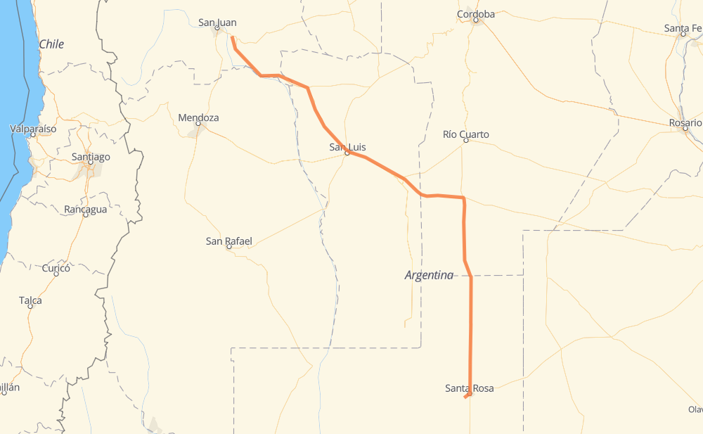
The distance from Toay to Caucete is 807 kilometers by road. Road takes approximately 9 hours and 24 minutes and goes through Santa Rosa, San Luis, Zona Quintas Sur, Eduardo Castex and Vicuña Mackenna.
| Shortest distance by air | 664 km ✈️ |
| Car route length | 807 km 🚗 |
| Driving time | 9 h 24 min |
| Fuel amount | 64.5 L |
| Fuel cost | 126.5 CAD |
| Point | Distance | Time | Fuel | |
| Toay | 0 km | 00 min | 0.0 L | |
|
10 km, 07 min
|
||||
| Santa Rosa | 10 km | 07 min | 0.2 L | |
|
RN35 71 km, 50 min
|
||||
| Eduardo Castex | 81 km | 57 min | 4.5 L | |
|
RN35 121 km, 1 h 23 min
|
||||
| Watt | 202 km | 2 h 21 min | 15.3 L | |
|
RN35 96 km, 1 h 05 min
|
||||
| Vicuña Mackenna | 298 km | 3 h 27 min | 22.5 L | |
|
RN35 RN7 156 km, 1 h 44 min
|
||||
| Fraga | 455 km | 5 h 12 min | 35.3 L | |
|
RN7 14 km, 09 min
|
||||
| Comandante Granville | 469 km | 5 h 21 min | 37.4 L | |
|
RN7 45 km, 30 min
|
||||
| San Luis | 513 km | 5 h 52 min | 40.7 L | |
|
RN147 236 km, 2 h 47 min
|
||||
| Encón | 750 km | 8 h 40 min | 57.5 L | |
|
RN20 57 km, 43 min
|
||||
| Caucete | 807 km | 9 h 23 min | 63.9 L | |
Hotels of Caucete
Frequently Asked Questions
How much does it cost to drive from Toay to Caucete?
Fuel cost: 126.5 CAD
This fuel cost is calculated as: (Route length 807 km / 100 km) * (Fuel consumption 8 L/100 km) * (Fuel price 1.96 CAD / L)
You can adjust fuel consumption and fuel price here.
How long is a car ride from Toay to Caucete?
Driving time: 9 h 24 min
This time is calculated for driving at the maximum permitted speed, taking into account traffic rules restrictions.
- 530 km with a maximum speed 90 km/h = 5 h 53 min
- 272 km with a maximum speed 80 km/h = 3 h 23 min
- 2 km with a maximum speed 60 km/h = 1 min
- 2 km with a maximum speed 40 km/h = 3 min
The calculated driving time does not take into account intermediate stops and traffic jams.
How far is Toay to Caucete by land?
The distance between Toay and Caucete is 807 km by road.
Precise satellite coordinates of highways were used for this calculation. The start and finish points are the centers of Toay and Caucete respectively.
How far is Toay to Caucete by plane?
The shortest distance (air line, as the crow flies) between Toay and Caucete is 664 km.
This distance is calculated using the Haversine formula as a great-circle distance between two points on the surface of a sphere. The start and finish points are the centers of Toay and Caucete respectively. Actual distance between airports may be different.
How many hours is Toay from Caucete by plane?
Boeing 737 airliner needs 49 min to cover the distance of 664 km at a cruising speed of 800 km/h.
Small plane "Cessna 172" needs 3 h 1 min to flight this distance at average speed of 220 km/h.
This time is approximate and do not take into account takeoff and landing times, airport location and other real world factors.
How long is a helicopter ride from Toay to Caucete?
Fast helicopter "Eurocopter AS350" or "Hughes OH-6 Cayuse" need 2 h 46 min to cover the distance of 664 km at a cruising speed of 240 km/h.
Popular "Robinson R44" needs 3 h 9 min to flight this distance at average speed of 210 km/h.
This time is approximate and do not take into account takeoff and landing times, aerodrome location and other real world factors.
What city is halfway between Toay and Caucete?
The halfway point between Toay and Caucete is Fraga. It is located about 51 km from the exact midpoint by road.
The distance from Fraga to Toay is 455 km and driving will take about 5 h 12 min. The road between Fraga and Caucete has length 352 km and will take approximately 4 h 11 min.
The other cities located close to halfway point:
Where is Toay in relation to Caucete?
Toay is located 664 km south-east of Caucete.
Toay has geographic coordinates: latitude -36.67384, longitude -64.37968.
Caucete has geographic coordinates: latitude -31.6515, longitude -68.28204.
Which highway goes from Toay to Caucete?
The route from Toay to Caucete follows RN35, RN7, RN20, RN147.
Other minor sections pass along the road:
- RP203: 7 km