Distance between Tenango de Arista and Tancha
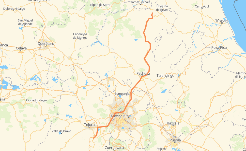
The distance from Tenango de Arista to Tancha is 366 kilometers by road including 134 kilometers on motorways. Road takes approximately 4 hours and 52 minutes and goes through Pachuca, Santa Maria Rayon, Lerma de Villada, Ocoyoacac, La Marquesa, Cuajimalpa de Morelos and Naucalpan de Juarez.
| Shortest distance by air | 248 km ✈️ |
| Car route length | 366 km 🚗 |
| Driving time | 4 h 52 min |
| Fuel amount | 29.2 L |
| Fuel cost | 57.3 CAD |
| Toll roads cost | 137 + ? MXN |
| Point | Distance | Time | Fuel | |
| Tenango de Arista | 0 km | 00 min | 0.0 L | |
|
MEX 55 6 km, 05 min
|
||||
| Santa Maria Rayon | 6 km | 05 min | 0.3 L | |
|
MEX 55 21 km, 13 min
|
||||
| Lerma de Villada | 27 km | 18 min | 2.0 L | |
|
MEX 15 5 km, 03 min
|
||||
| Ocoyoacac | 33 km | 22 min | 2.4 L | |
|
MEX 15D 10 km, 06 min
|
||||
| La Marquesa | 43 km | 29 min | 3.1 L | |
|
MEX 15D 12 km, 08 min
|
||||
| Cuajimalpa de Morelos | 55 km | 38 min | 4.0 L | |
|
MEX 57D 19 km, 13 min
|
||||
| Naucalpan de Juarez | 73 km | 52 min | 5.7 L | |
|
6 km, 04 min
|
||||
| Tlalnepantla | 80 km | 56 min | 6.2 L | |
|
MEX 85 94 km, 1 h 06 min
|
||||
| Pachuca | 174 km | 2 h 03 min | 13.3 L | |
|
MEX 85 MEX 105 217 km, 2 h 48 min
|
||||
| Tancha | 391 km | 4 h 52 min | 31.2 L | |
Frequently Asked Questions
How many toll booths are there from Tenango de Arista to Tancha?
There are 10 toll booths between Tenango de Arista and Tancha: Rayón, Chapultepec, Libramiento la Marquesa, La Venta, La Venta - Chamapa, Chamapa IDEAL, Ojo de Agua, Revolucion, San Cristobal and México - Pachuca.
How much does the toll booths cost from Tenango de Arista to Tancha?
Toll roads cost: Rayón (38 MXN) + Chapultepec (43 MXN) + Libramiento la Marquesa (?) + La Venta (?) + La Venta - Chamapa (?) + Chamapa IDEAL (?) + México - Pachuca (?) + San Cristobal (?) + Revolucion (?) + Ojo de Agua (56 MXN) = 137 + ? MXN
How much does it cost to drive from Tenango de Arista to Tancha?
Fuel cost: 57.3 CAD
This fuel cost is calculated as: (Route length 366 km / 100 km) * (Fuel consumption 8 L/100 km) * (Fuel price 1.96 CAD / L)
You can adjust fuel consumption and fuel price here.
Toll roads cost: 137 + ? MXN
How long is a car ride from Tenango de Arista to Tancha?
Driving time: 4 h 52 min
This time is calculated for driving at the maximum permitted speed, taking into account traffic rules restrictions.
- 46 km with a maximum speed 100 km/h = 27 min
- 19 km with a maximum speed 90 km/h = 12 min
- 303 km with a maximum speed 80 km/h = 3 h 47 min
- 5 km with a maximum speed 60 km/h = 5 min
- 15 km with a maximum speed 50 km/h = 18 min
The calculated driving time does not take into account intermediate stops and traffic jams.
How far is Tenango de Arista to Tancha by land?
The distance between Tenango de Arista and Tancha is 366 km by road including 134 km on motorways.
Precise satellite coordinates of highways were used for this calculation. The start and finish points are the centers of Tenango de Arista and Tancha respectively.
How far is Tenango de Arista to Tancha by plane?
The shortest distance (air line, as the crow flies) between Tenango de Arista and Tancha is 248 km.
This distance is calculated using the Haversine formula as a great-circle distance between two points on the surface of a sphere. The start and finish points are the centers of Tenango de Arista and Tancha respectively. Actual distance between airports may be different.
How many hours is Tenango de Arista from Tancha by plane?
Boeing 737 airliner needs 18 min to cover the distance of 248 km at a cruising speed of 800 km/h.
Small plane "Cessna 172" needs 1 h 7 min to flight this distance at average speed of 220 km/h.
This time is approximate and do not take into account takeoff and landing times, airport location and other real world factors.
How long is a helicopter ride from Tenango de Arista to Tancha?
Fast helicopter "Eurocopter AS350" or "Hughes OH-6 Cayuse" need 1 h 2 min to cover the distance of 248 km at a cruising speed of 240 km/h.
Popular "Robinson R44" needs 1 h 10 min to flight this distance at average speed of 210 km/h.
This time is approximate and do not take into account takeoff and landing times, aerodrome location and other real world factors.
What city is halfway between Tenango de Arista and Tancha?
The halfway point between Tenango de Arista and Tancha is Velasco. It is located about 5 km from the exact midpoint by road.
The distance from Velasco to Tenango de Arista is 187 km and driving will take about 2 h 13 min. The road between Velasco and Tancha has length 178 km and will take approximately 2 h 38 min.
The other cities located close to halfway point:
Where is Tenango de Arista in relation to Tancha?
Tenango de Arista is located 248 km south-west of Tancha.
Tenango de Arista has geographic coordinates: latitude 19.10448, longitude -99.59081.
Tancha has geographic coordinates: latitude 21.12222, longitude -98.57972.
Which highway goes from Tenango de Arista to Tancha?
The route from Tenango de Arista to Tancha follows MEX 105.
Other minor sections pass along the road:
- MEX 85: 41 km
- MEX 85D: 37 km
- MEX 15D: 20 km
- MEX 57D: 11 km
- MEX 55: 4 km
- MEX 15: 2 km
- MEX 57: 2 km
- MEX15D: 1 km