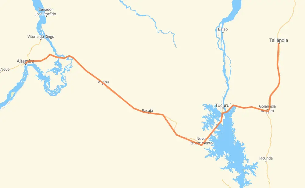
Distance between Tailândia and Altamira
The distance from Tailândia to Altamira is 563 kilometers by road. Road takes approximately 6 hours and 50 minutes and goes through Vila Residencial Belo Monte, Águas Claras, Bom Jesus, Genésio, Nossa Senhora Aparecida, Campos Belos and Vila São João.
| Shortest distance by air | 363 km ✈️ |
| Car route length | 563 km 🚗 |
| Driving time | 6 h 50 min |
| Fuel amount | 45 L |
| Fuel cost | 89.2 CAD |
| Point | Distance | Time | Fuel | |
| Tailândia | 0 km | 00 min | 0.0 L | |
|
PA-150 74 km, 55 min
|
||||
| Nossa Senhora Aparecida | 74 km | 55 min | 5.2 L | |
|
PA-150 60 km, 55 min
|
||||
| Vila São João | 134 km | 1 h 51 min | 8.5 L | |
|
PA-263 BR-230 195 km, 2 h 13 min
|
||||
| Aratau | 329 km | 4 h 05 min | 25.1 L | |
|
BR-230 73 km, 50 min
|
||||
| Nazaré | 402 km | 4 h 55 min | 31.0 L | |
|
BR-230 38 km, 26 min
|
||||
| Sucupira | 440 km | 5 h 22 min | 34.9 L | |
|
BR-230 36 km, 25 min
|
||||
| Vila Isabel | 476 km | 5 h 48 min | 37.1 L | |
|
BR-230 17 km, 12 min
|
||||
| Belo Monte do Pontal | 492 km | 6 h 01 min | 39.1 L | |
|
BR-230 8 km, 06 min
|
||||
| Vila Residencial Belo Monte | 500 km | 6 h 07 min | 39.7 L | |
|
BR-230 6 km, 04 min
|
||||
| Santo Antônio | 507 km | 6 h 12 min | 40.4 L | |
|
BR-230 56 km, 37 min
|
||||
| -3.20407, -52.20996 | 563 km | 6 h 50 min | 45.0 L | |
Hotels of Altamira
Frequently Asked Questions
How much does it cost to drive from Tailândia to Altamira?
Fuel cost: 89.2 CAD
This fuel cost is calculated as: (Route length 563 km / 100 km) * (Fuel consumption 8 L/100 km) * (Fuel price 1.98 CAD / L)
You can adjust fuel consumption and fuel price here.
How long is a car ride from Tailândia to Altamira?
Driving time: 6 h 50 min
This time is calculated for driving at the maximum permitted speed, taking into account traffic rules restrictions.
- 291 km with a maximum speed 90 km/h = 3 h 13 min
- 256 km with a maximum speed 80 km/h = 3 h 11 min
- 15 km with a maximum speed 40 km/h = 22 min
The calculated driving time does not take into account intermediate stops and traffic jams.
How far is Tailândia to Altamira by land?
The distance between Tailândia and Altamira is 563 km by road.
Precise satellite coordinates of highways were used for this calculation. The start and finish points are the centers of Tailândia and Altamira respectively.
How far is Tailândia to Altamira by plane?
The shortest distance (air line, as the crow flies) between Tailândia and Altamira is 363 km.
This distance is calculated using the Haversine formula as a great-circle distance between two points on the surface of a sphere. The start and finish points are the centers of Tailândia and Altamira respectively. Actual distance between airports may be different.
How many hours is Tailândia from Altamira by plane?
Boeing 737 airliner needs 27 min to cover the distance of 363 km at a cruising speed of 800 km/h.
Small plane "Cessna 172" needs 1 h 39 min to flight this distance at average speed of 220 km/h.
This time is approximate and do not take into account takeoff and landing times, airport location and other real world factors.
How long is a helicopter ride from Tailândia to Altamira?
Fast helicopter "Eurocopter AS350" or "Hughes OH-6 Cayuse" need 1 h 30 min to cover the distance of 363 km at a cruising speed of 240 km/h.
Popular "Robinson R44" needs 1 h 43 min to flight this distance at average speed of 210 km/h.
This time is approximate and do not take into account takeoff and landing times, aerodrome location and other real world factors.
What city is halfway between Tailândia and Altamira?
The halfway point between Tailândia and Altamira is Aratau. It is located about 48 km from the exact midpoint by road.
The distance from Aratau to Tailândia is 329 km and driving will take about 4 h 5 min. The road between Aratau and Altamira has length 233 km and will take approximately 2 h 45 min.
Where is Tailândia in relation to Altamira?
Tailândia is located 363 km east of Altamira.
Tailândia has geographic coordinates: latitude -2.9361, longitude -48.95234.
Altamira has geographic coordinates: latitude -3.20407, longitude -52.20996.
Which highway goes from Tailândia to Altamira?
The route from Tailândia to Altamira follows BR-230, PA-150, PA-475.
Other minor sections pass along the road:
- PA-263: 73 km
- BR-422: 60 km