Distance between Springfield and Makoro
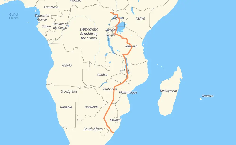
The distance from Springfield to Makoro is 5,663 kilometers by road including 520 kilometers on motorways. Road takes approximately 67 hours and 40 minutes and goes through Pietermaritzburg, Mokopane, Louis Trichardt, Masvingo, Harare, Tete and Mzuzu.
| Shortest distance by air | 3,667 km ✈️ |
| Car route length | 5,663 km 🚗 |
| Driving time | 67 h 40 min |
| Fuel amount | 453.1 L |
| Fuel cost | 892.5 CAD |
| Point | Distance | Time | Fuel | |
| -29.82056, 30.99500 | 0 km | 00 min | 0.0 L | |
|
N3 78 km, 45 min
|
||||
| Pietermaritzburg | 78 km | 45 min | 12.3 L | |
|
N3 742 km, 7 h 34 min
|
||||
| Mokopane | 821 km | 8 h 20 min | 71.6 L | |
|
N1 168 km, 1 h 55 min
|
||||
| Louis Trichardt | 988 km | 10 h 15 min | 84.6 L | |
|
N1 A4 396 km, 4 h 27 min
|
||||
| Masvingo | 1,385 km | 14 h 42 min | 116.6 L | |
|
A4 294 km, 3 h 16 min
|
||||
| Harare | 1,679 km | 17 h 59 min | 140.2 L | |
|
R5 A2 377 km, 4 h 19 min
|
||||
| Tete | 2,056 km | 22 h 19 min | 170.2 L | |
|
N7 M5 722 km, 8 h 41 min
|
||||
| Mzuzu | 2,778 km | 31 h 00 min | 227.1 L | |
|
M5 M1 662 km, 8 h 25 min
|
||||
| Iringa | 3,441 km | 39 h 25 min | 276.8 L | |
|
T1 T5 309 km, 4 h 14 min
|
||||
| Dodoma | 3,749 km | 43 h 40 min | 304.7 L | |
|
T3 963 km, 11 h 52 min
|
||||
| Bukoba | 4,712 km | 55 h 32 min | 382.5 L | |
|
T4 175 km, 2 h 11 min
|
||||
| Masaka | 4,887 km | 57 h 44 min | 397.0 L | |
|
BWAISE I 14302 621 km, 7 h 37 min
|
||||
| Arua | 5,508 km | 65 h 21 min | 446.5 L | |
|
RP434 155 km, 2 h 18 min
|
||||
| Makoro | 5,663 km | 67 h 40 min | 458.2 L | |
Frequently Asked Questions
How much does it cost to drive from Springfield to Makoro?
Fuel cost: 892.5 CAD
This fuel cost is calculated as: (Route length 5,663 km / 100 km) * (Fuel consumption 8 L/100 km) * (Fuel price 1.97 CAD / L)
You can adjust fuel consumption and fuel price here.
How long is a car ride from Springfield to Makoro?
Driving time: 67 h 40 min
This time is calculated for driving at the maximum permitted speed, taking into account traffic rules restrictions.
- 335 km with a maximum speed 110 km/h = 3 h 2 min
- 179 km with a maximum speed 100 km/h = 1 h 47 min
- 2,263 km with a maximum speed 90 km/h = 25 h 8 min
- 2,657 km with a maximum speed 80 km/h = 33 h 12 min
- 11 km with a maximum speed 70 km/h = 9 min
- 11 km with a maximum speed 60 km/h = 10 min
- 206 km with a maximum speed 50 km/h = 4 h 7 min
- 1 km with a maximum speed 40 km/h = 1 min
The calculated driving time does not take into account intermediate stops and traffic jams.
How far is Springfield to Makoro by land?
The distance between Springfield and Makoro is 5,663 km by road including 520 km on motorways.
Precise satellite coordinates of highways were used for this calculation. The start and finish points are the centers of Springfield and Makoro respectively.
How far is Springfield to Makoro by plane?
The shortest distance (air line, as the crow flies) between Springfield and Makoro is 3,667 km.
This distance is calculated using the Haversine formula as a great-circle distance between two points on the surface of a sphere. The start and finish points are the centers of Springfield and Makoro respectively. Actual distance between airports may be different.
How many hours is Springfield from Makoro by plane?
Boeing 737 airliner needs 4 h 35 min to cover the distance of 3,667 km at a cruising speed of 800 km/h.
Small plane "Cessna 172" needs 16 h 40 min to flight this distance at average speed of 220 km/h.
This time is approximate and do not take into account takeoff and landing times, airport location and other real world factors.
How long is a helicopter ride from Springfield to Makoro?
Fast helicopter "Eurocopter AS350" or "Hughes OH-6 Cayuse" need 15 h 16 min to cover the distance of 3,667 km at a cruising speed of 240 km/h.
Popular "Robinson R44" needs 17 h 27 min to flight this distance at average speed of 210 km/h.
This time is approximate and do not take into account takeoff and landing times, aerodrome location and other real world factors.
What city is halfway between Springfield and Makoro?
The halfway point between Springfield and Makoro is Enukweni. It is located about 5 km from the exact midpoint by road.
The distance from Enukweni to Springfield is 2,837 km and driving will take about 31 h 42 min. The road between Enukweni and Makoro has length 2,826 km and will take approximately 35 h 58 min.
The other cities located close to halfway point:
Where is Springfield in relation to Makoro?
Springfield is located 3,667 km south of Makoro.
Springfield has geographic coordinates: latitude -29.82056, longitude 30.995.
Makoro has geographic coordinates: latitude 3.13359, longitude 29.88307.
Which highway goes from Springfield to Makoro?
The route from Springfield to Makoro follows T3, A4, N3, N1, M5, M1, T1, T5, T4, A2, N7, T10.
Other minor sections pass along the road:
- M6: 57 km
- N8: 49 km
- T9: 40 km
- T8: 39 km
- N4: 10 km
- MASAKA KAKUTO ROAD: 9 km
- N12: 7 km
- BWAISE I 14302: 6 km
- R523: 5 km
- M10: 3 km
- R5: 1 km
- R2: 1 km
- N1 section 21 North: 1 km
- RP434: 1 km