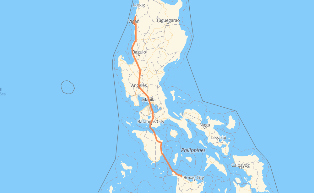
Distance between Sinait and Makato
The distance from Sinait to Makato is 859 kilometers by road including 297 kilometers on motorways. Road takes approximately 15 hours and 41 minutes and goes through Candon, San Fernando, San Pedro, Biñan, Santa Rosa, Cabuyao and Calamba.
| Shortest distance by air | 712 km ✈️ |
| Car route length | 859 km 🚗 |
| Driving time | 15 h 41 min |
| Fuel amount | 68.7 L |
| Fuel cost | 135.4 CAD |
| Point | Distance | Time | Fuel | |
| Sinait | 0 km | 00 min | 0.0 L | |
|
2 96 km, 1 h 24 min
|
||||
| Candon | 96 km | 1 h 24 min | 7.2 L | |
|
2 76 km, 1 h 07 min
|
||||
| San Fernando | 172 km | 2 h 32 min | 13.7 L | |
|
2 E1 295 km, 3 h 25 min
|
||||
| San Pedro | 467 km | 5 h 57 min | 37.2 L | |
|
E2 5 km, 03 min
|
||||
| Biñan | 472 km | 6 h 01 min | 37.5 L | |
|
E2 6 km, 03 min
|
||||
| Santa Rosa | 478 km | 6 h 04 min | 38.1 L | |
|
E2 3 km, 01 min
|
||||
| Cabuyao | 482 km | 6 h 06 min | 38.5 L | |
|
E2 6 km, 03 min
|
||||
| Calamba | 488 km | 6 h 10 min | 38.6 L | |
|
E2 11 km, 06 min
|
||||
| Tanauan | 499 km | 6 h 17 min | 39.7 L | |
|
E2 16 km, 09 min
|
||||
| Lipa | 515 km | 6 h 26 min | 40.9 L | |
|
E2 25 km, 17 min
|
||||
| Batangas City | 540 km | 6 h 44 min | 42.8 L | |
|
434 452 51 km, 2 h 17 min
|
||||
| Calapan | 591 km | 9 h 01 min | 47.2 L | |
|
452 268 km, 6 h 39 min
|
||||
| Makato | 859 km | 15 h 41 min | 68.5 L | |
Frequently Asked Questions
How much does it cost to drive from Sinait to Makato?
Fuel cost: 135.4 CAD
This fuel cost is calculated as: (Route length 859 km / 100 km) * (Fuel consumption 8 L/100 km) * (Fuel price 1.97 CAD / L)
You can adjust fuel consumption and fuel price here.
How long is a car ride from Sinait to Makato?
Driving time: 15 h 41 min
This time is calculated for driving at the maximum permitted speed, taking into account traffic rules restrictions.
- 288 km with a maximum speed 100 km/h = 2 h 53 min
- 20 km with a maximum speed 90 km/h = 13 min
- 313 km with a maximum speed 80 km/h = 3 h 54 min
- 4 km with a maximum speed 70 km/h = 3 min
- 66 km with a maximum speed 60 km/h = 1 h 5 min
- 10 km with a maximum speed 50 km/h = 11 min
- 15 km with a maximum speed 40 km/h = 23 min
- 11 km with a maximum speed 30 km/h = 21 min
- 131 km with a maximum speed 20 km/h = 6 h 34 min
The calculated driving time does not take into account intermediate stops and traffic jams.
How far is Sinait to Makato by land?
The distance between Sinait and Makato is 859 km by road including 297 km on motorways.
Precise satellite coordinates of highways were used for this calculation. The start and finish points are the centers of Sinait and Makato respectively.
How far is Sinait to Makato by plane?
The shortest distance (air line, as the crow flies) between Sinait and Makato is 712 km.
This distance is calculated using the Haversine formula as a great-circle distance between two points on the surface of a sphere. The start and finish points are the centers of Sinait and Makato respectively. Actual distance between airports may be different.
How many hours is Sinait from Makato by plane?
Boeing 737 airliner needs 53 min to cover the distance of 712 km at a cruising speed of 800 km/h.
Small plane "Cessna 172" needs 3 h 14 min to flight this distance at average speed of 220 km/h.
This time is approximate and do not take into account takeoff and landing times, airport location and other real world factors.
How long is a helicopter ride from Sinait to Makato?
Fast helicopter "Eurocopter AS350" or "Hughes OH-6 Cayuse" need 2 h 58 min to cover the distance of 712 km at a cruising speed of 240 km/h.
Popular "Robinson R44" needs 3 h 23 min to flight this distance at average speed of 210 km/h.
This time is approximate and do not take into account takeoff and landing times, aerodrome location and other real world factors.
What city is halfway between Sinait and Makato?
The halfway point between Sinait and Makato is Patubig. It is located about 13 km from the exact midpoint by road.
The distance from Patubig to Sinait is 417 km and driving will take about 5 h 19 min. The road between Patubig and Makato has length 443 km and will take approximately 10 h 22 min.
The other cities located close to halfway point:
Where is Sinait in relation to Makato?
Sinait is located 712 km north-west of Makato.
Sinait has geographic coordinates: latitude 17.86643, longitude 120.45616.
Makato has geographic coordinates: latitude 11.71167, longitude 122.29268.
Which highway goes from Sinait to Makato?
The route from Sinait to Makato follows 2, E1, 452.
Other minor sections pass along the road:
- E2: 93 km
- AH26: 40 km
- 503: 34 km
- 502: 23 km
- 454: 21 km
- 140: 5 km
- 160: 4 km
- 434: 4 km
- 145: 3 km
- 161: 1 km