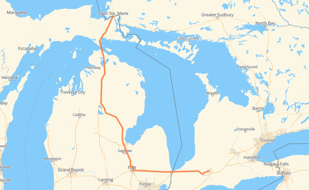
Distance between Sault Ste. Marie ON and London ON
The distance from Sault Ste. Marie to London is 668 kilometers by road including 641 kilometers on motorways. Road takes approximately 6 hours and 37 minutes and goes through Flint, Sarnia, Burton and Port Huron.
| Shortest distance by air | 462 km ✈️ |
| Car route length | 668 km 🚗 |
| Driving time | 6 h 37 min |
| Fuel amount | 53.4 L |
| Fuel cost | 104.7 CAD |
| Point | Distance | Time | Fuel | |
| Sault Ste. Marie | 0 km | 00 min | 0.0 L | |
|
I 75 21 km, 15 min
|
||||
| Dafter | 21 km | 15 min | 0.6 L | |
|
I 75 96 km, 1 h 02 min
|
||||
| Mackinaw City | 116 km | 1 h 18 min | 7.6 L | |
|
I 75 62 km, 33 min
|
||||
| Vanderbilt | 178 km | 1 h 52 min | 13.4 L | |
|
I 75 25 km, 13 min
|
||||
| Otsego Lake | 203 km | 2 h 06 min | 15.7 L | |
|
I 75 253 km, 2 h 19 min
|
||||
| Flint | 456 km | 4 h 25 min | 36.2 L | |
|
I 475 I 69 8 km, 05 min
|
||||
| Burton | 464 km | 4 h 30 min | 36.9 L | |
|
I 69 99 km, 1 h 00 min
|
||||
| Port Huron | 563 km | 5 h 30 min | 45.0 L | |
|
I 69 402 13 km, 08 min
|
||||
| Sarnia | 576 km | 5 h 39 min | 45.4 L | |
|
402 92 km, 58 min
|
||||
| London | 668 km | 6 h 37 min | 52.9 L | |
Hotels of London
Frequently Asked Questions
How much does it cost to drive from Sault Ste. Marie to London?
Fuel cost: 104.7 CAD
This fuel cost is calculated as: (Route length 668 km / 100 km) * (Fuel consumption 8 L/100 km) * (Fuel price 1.96 CAD / L)
You can adjust fuel consumption and fuel price here.
How long is a car ride from Sault Ste. Marie to London?
Driving time: 6 h 37 min
This time is calculated for driving at the maximum permitted speed, taking into account traffic rules restrictions.
- 426 km with a maximum speed 110 km/h = 3 h 52 min
- 148 km with a maximum speed 100 km/h = 1 h 28 min
- 3 km with a maximum speed 89 km/h = 1 min
- 66 km with a maximum speed 80 km/h = 49 min
- 8 km with a maximum speed 72 km/h = 6 min
- 5 km with a maximum speed 70 km/h = 4 min
- 6 km with a maximum speed 60 km/h = 5 min
- 5 km with a maximum speed 50 km/h = 6 min
- 2 km with a maximum speed 40 km/h = 2 min
The calculated driving time does not take into account intermediate stops and traffic jams.
How far is Sault Ste. Marie to London by land?
The distance between Sault Ste. Marie and London is 668 km by road including 641 km on motorways.
Precise satellite coordinates of highways were used for this calculation. The start and finish points are the centers of Sault Ste. Marie and London respectively.
How far is Sault Ste. Marie to London by plane?
The shortest distance (air line, as the crow flies) between Sault Ste. Marie and London is 462 km.
This distance is calculated using the Haversine formula as a great-circle distance between two points on the surface of a sphere. The start and finish points are the centers of Sault Ste. Marie and London respectively. Actual distance between airports may be different.
How many hours is Sault Ste. Marie from London by plane?
Boeing 737 airliner needs 34 min to cover the distance of 462 km at a cruising speed of 800 km/h.
Small plane "Cessna 172" needs 2 h 6 min to flight this distance at average speed of 220 km/h.
This time is approximate and do not take into account takeoff and landing times, airport location and other real world factors.
How long is a helicopter ride from Sault Ste. Marie to London?
Fast helicopter "Eurocopter AS350" or "Hughes OH-6 Cayuse" need 1 h 55 min to cover the distance of 462 km at a cruising speed of 240 km/h.
Popular "Robinson R44" needs 2 h 12 min to flight this distance at average speed of 210 km/h.
This time is approximate and do not take into account takeoff and landing times, aerodrome location and other real world factors.
What city is halfway between Sault Ste. Marie and London?
The halfway point between Sault Ste. Marie and London is Three Churches Corner. It is located about 39 km from the exact midpoint by road.
The distance from Three Churches Corner to Sault Ste. Marie is 373 km and driving will take about 3 h 38 min. The road between Three Churches Corner and London has length 295 km and will take approximately 2 h 59 min.
The other cities located close to halfway point:
Where is Sault Ste. Marie in relation to London?
Sault Ste. Marie is located 462 km north-west of London.
Sault Ste. Marie has geographic coordinates: latitude 46.52391, longitude -84.32007.
London has geographic coordinates: latitude 42.98858, longitude -81.24664.
Which highway goes from Sault Ste. Marie to London?
The route from Sault Ste. Marie to London follows I 75, I 69.
Other minor sections pass along the road:
- US 23: 99 km
- 402: 81 km
- I 475: 15 km
- 14: 8 km
- I 94: 5 km