Distance between Santa Helena and Cuiabá
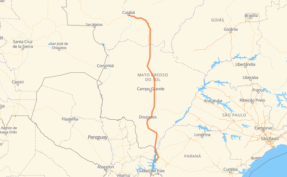
The distance from Santa Helena to Cuiabá is 1,303 kilometers by road including 119 kilometers on motorways. Road takes approximately 15 hours and 8 minutes and goes through Mundo Novo, Itaquiraí, Caarapó, Rio Brilhante, Nova Alvorada do Sul, Chácara das Mansões and Moradia do Sol.
| Shortest distance by air | 1,046 km ✈️ |
| Car route length | 1,303 km 🚗 |
| Driving time | 15 h 8 min |
| Fuel amount | 104.3 L |
| Fuel cost | 204.4 CAD |
| Point | Distance | Time | Fuel | |
| -24.85917, -54.33288 | 0 km | 00 min | 0.0 L | |
|
BR-163 138 km, 1 h 38 min
|
||||
| Mundo Novo | 138 km | 1 h 38 min | 21.2 L | |
|
BR-163 61 km, 43 min
|
||||
| Itaquiraí | 199 km | 2 h 22 min | 26.0 L | |
|
BR-163 130 km, 1 h 32 min
|
||||
| Caarapó | 329 km | 3 h 54 min | 36.4 L | |
|
BR-163 111 km, 1 h 16 min
|
||||
| Rio Brilhante | 440 km | 5 h 10 min | 45.5 L | |
|
BR-163 36 km, 24 min
|
||||
| Nova Alvorada do Sul | 476 km | 5 h 35 min | 47.6 L | |
|
BR-163 91 km, 1 h 02 min
|
||||
| Chácara das Mansões | 566 km | 6 h 37 min | 54.8 L | |
|
BR-163 19 km, 14 min
|
||||
| Moradia do Sol | 585 km | 6 h 52 min | 57.0 L | |
|
BR-163 24 km, 18 min
|
||||
| Nova Lima | 610 km | 7 h 10 min | 59.2 L | |
|
BR-163 125 km, 1 h 27 min
|
||||
| São Gabriel do Oeste | 734 km | 8 h 38 min | 69.0 L | |
|
BR-163 569 km, 6 h 29 min
|
||||
| Cuiabá | 1,303 km | 15 h 07 min | 114.4 L | |
Hotels of Cuiabá
Frequently Asked Questions
How much does it cost to drive from Santa Helena to Cuiabá?
Fuel cost: 204.4 CAD
This fuel cost is calculated as: (Route length 1,303 km / 100 km) * (Fuel consumption 8 L/100 km) * (Fuel price 1.96 CAD / L)
You can adjust fuel consumption and fuel price here.
How long is a car ride from Santa Helena to Cuiabá?
Driving time: 15 h 8 min
This time is calculated for driving at the maximum permitted speed, taking into account traffic rules restrictions.
- 88 km with a maximum speed 100 km/h = 52 min
- 822 km with a maximum speed 90 km/h = 9 h 8 min
- 365 km with a maximum speed 80 km/h = 4 h 33 min
- 18 km with a maximum speed 60 km/h = 18 min
- 1 km with a maximum speed 50 km/h = 1 min
- 10 km with a maximum speed 40 km/h = 14 min
The calculated driving time does not take into account intermediate stops and traffic jams.
How far is Santa Helena to Cuiabá by land?
The distance between Santa Helena and Cuiabá is 1,303 km by road including 119 km on motorways.
Precise satellite coordinates of highways were used for this calculation. The start and finish points are the centers of Santa Helena and Cuiabá respectively.
How far is Santa Helena to Cuiabá by plane?
The shortest distance (air line, as the crow flies) between Santa Helena and Cuiabá is 1,046 km.
This distance is calculated using the Haversine formula as a great-circle distance between two points on the surface of a sphere. The start and finish points are the centers of Santa Helena and Cuiabá respectively. Actual distance between airports may be different.
How many hours is Santa Helena from Cuiabá by plane?
Boeing 737 airliner needs 1 h 18 min to cover the distance of 1,046 km at a cruising speed of 800 km/h.
Small plane "Cessna 172" needs 4 h 45 min to flight this distance at average speed of 220 km/h.
This time is approximate and do not take into account takeoff and landing times, airport location and other real world factors.
How long is a helicopter ride from Santa Helena to Cuiabá?
Fast helicopter "Eurocopter AS350" or "Hughes OH-6 Cayuse" need 4 h 21 min to cover the distance of 1,046 km at a cruising speed of 240 km/h.
Popular "Robinson R44" needs 4 h 58 min to flight this distance at average speed of 210 km/h.
This time is approximate and do not take into account takeoff and landing times, aerodrome location and other real world factors.
What city is halfway between Santa Helena and Cuiabá?
The halfway point between Santa Helena and Cuiabá is Bandeirantes. It is located about 24 km from the exact midpoint by road.
The distance from Bandeirantes to Santa Helena is 675 km and driving will take about 7 h 56 min. The road between Bandeirantes and Cuiabá has length 628 km and will take approximately 7 h 11 min.
The other cities located close to halfway point:
Where is Santa Helena in relation to Cuiabá?
Santa Helena is located 1,046 km south of Cuiabá.
Santa Helena has geographic coordinates: latitude -24.85917, longitude -54.33288.
Cuiabá has geographic coordinates: latitude -15.59867, longitude -56.09913.
Which highway goes from Santa Helena to Cuiabá?
The route from Santa Helena to Cuiabá follows BR-163, BR-364, BR-060.
Other minor sections pass along the road:
- BR-070: 85 km
- BR-487: 62 km
- BR-267: 41 km
- PR-495: 40 km
- BR-262: 15 km
- PR-317: 15 km
- BR-467: 11 km
- PRC-467: 11 km