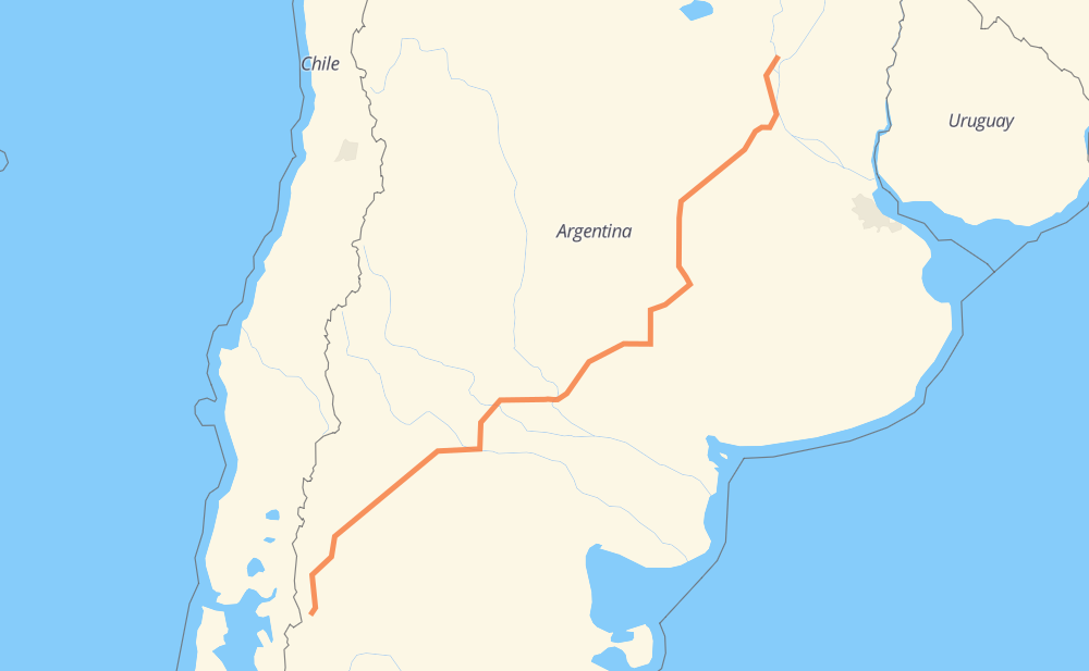
Distance between Santa Fe and El Bolsón
The distance from Santa Fe to El Bolsón is 1,877 kilometers by road including 144 kilometers on motorways. Road takes approximately 21 hours and 35 minutes and goes through Neuquén, San Carlos de Bariloche, San Eduardo, San Lorenzo, Roldán, Santa Teresa and Casilda.
| Shortest distance by air | 1,499 km ✈️ |
| Car route length | 1,877 km 🚗 |
| Driving time | 21 h 35 min |
| Fuel amount | 150.2 L |
| Fuel cost | 294.3 CAD |
| Point | Distance | Time | Fuel | |
| Santa Fe | 0 km | 00 min | 0.0 L | |
|
AP01 147 km, 1 h 22 min
|
||||
| San Eduardo | 147 km | 1 h 22 min | 11.5 L | |
|
RNA012 23 km, 17 min
|
||||
| Roldán | 170 km | 1 h 40 min | 13.4 L | |
|
RNA012 RN33 38 km, 28 min
|
||||
| Casilda | 208 km | 2 h 08 min | 16.4 L | |
|
RN33 55 km, 43 min
|
||||
| Firmat | 263 km | 2 h 51 min | 20.9 L | |
|
RN33 50 km, 36 min
|
||||
| Cumelén | 313 km | 3 h 28 min | 24.7 L | |
|
RN33 51 km, 36 min
|
||||
| Sancti Spíritu | 364 km | 4 h 05 min | 27.7 L | |
|
RN33 RN152 966 km, 11 h 00 min
|
||||
| Neuquén | 1,330 km | 15 h 05 min | 105.9 L | |
|
RN237 425 km, 5 h 05 min
|
||||
| San Carlos de Bariloche | 1,756 km | 20 h 11 min | 140.0 L | |
|
RP237 RN40 122 km, 1 h 23 min
|
||||
| El Bolsón | 1,877 km | 21 h 35 min | 149.9 L | |
Hotels of El Bolsón
Frequently Asked Questions
How much does it cost to drive from Santa Fe to El Bolsón?
Fuel cost: 294.3 CAD
This fuel cost is calculated as: (Route length 1,877 km / 100 km) * (Fuel consumption 8 L/100 km) * (Fuel price 1.96 CAD / L)
You can adjust fuel consumption and fuel price here.
How long is a car ride from Santa Fe to El Bolsón?
Driving time: 21 h 35 min
This time is calculated for driving at the maximum permitted speed, taking into account traffic rules restrictions.
- 140 km with a maximum speed 110 km/h = 1 h 16 min
- 1,495 km with a maximum speed 90 km/h = 16 h 36 min
- 88 km with a maximum speed 80 km/h = 1 h 6 min
- 145 km with a maximum speed 60 km/h = 2 h 25 min
- 2 km with a maximum speed 50 km/h = 2 min
- 3 km with a maximum speed 40 km/h = 5 min
- 1 km with a maximum speed 20 km/h = 1 min
The calculated driving time does not take into account intermediate stops and traffic jams.
How far is Santa Fe to El Bolsón by land?
The distance between Santa Fe and El Bolsón is 1,877 km by road including 144 km on motorways.
Precise satellite coordinates of highways were used for this calculation. The start and finish points are the centers of Santa Fe and El Bolsón respectively.
How far is Santa Fe to El Bolsón by plane?
The shortest distance (air line, as the crow flies) between Santa Fe and El Bolsón is 1,499 km.
This distance is calculated using the Haversine formula as a great-circle distance between two points on the surface of a sphere. The start and finish points are the centers of Santa Fe and El Bolsón respectively. Actual distance between airports may be different.
How many hours is Santa Fe from El Bolsón by plane?
Boeing 737 airliner needs 1 h 52 min to cover the distance of 1,499 km at a cruising speed of 800 km/h.
Small plane "Cessna 172" needs 6 h 48 min to flight this distance at average speed of 220 km/h.
This time is approximate and do not take into account takeoff and landing times, airport location and other real world factors.
How long is a helicopter ride from Santa Fe to El Bolsón?
Fast helicopter "Eurocopter AS350" or "Hughes OH-6 Cayuse" need 6 h 14 min to cover the distance of 1,499 km at a cruising speed of 240 km/h.
Popular "Robinson R44" needs 7 h 8 min to flight this distance at average speed of 210 km/h.
This time is approximate and do not take into account takeoff and landing times, aerodrome location and other real world factors.
What city is halfway between Santa Fe and El Bolsón?
The halfway point between Santa Fe and El Bolsón is General Acha. It is located about 34 km from the exact midpoint by road.
The distance from General Acha to Santa Fe is 904 km and driving will take about 10 h 13 min. The road between General Acha and El Bolsón has length 973 km and will take approximately 11 h 22 min.
The other cities located close to halfway point:
Where is Santa Fe in relation to El Bolsón?
Santa Fe is located 1,499 km north-east of El Bolsón.
Santa Fe has geographic coordinates: latitude -31.6187, longitude -60.70196.
El Bolsón has geographic coordinates: latitude -41.96498, longitude -71.53443.
Which highway goes from Santa Fe to El Bolsón?
The route from Santa Fe to El Bolsón follows RN33, RN237, RN152, AP01, RN40, RP6, RN5.
Other minor sections pass along the road:
- RP1: 70 km
- RN22: 62 km
- RP18: 55 km
- RNA012: 36 km
- RN35: 21 km
- RP237: 6 km