Distance between Santa Elena and Ciudad Mendoza
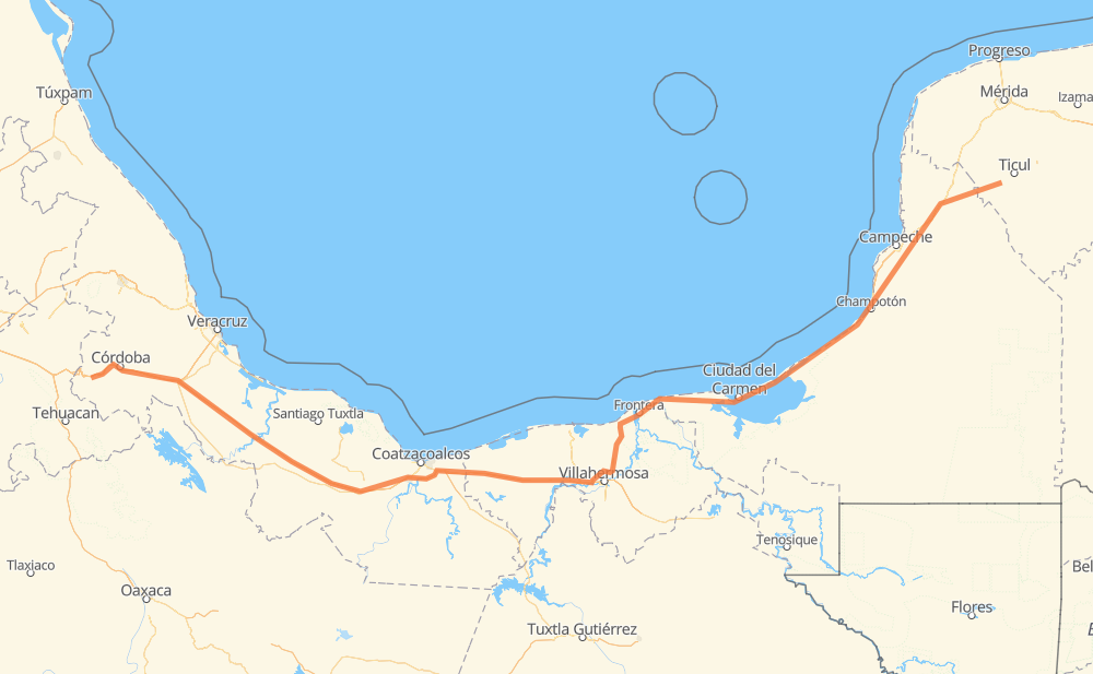
The distance from Santa Elena to Ciudad Mendoza is 1,030 kilometers by road including 462 kilometers on motorways. Road takes approximately 11 hours and 27 minutes and goes through Orizaba, Hecelchakán, Champotón, Frontera, Heroica Cárdenas, Ixtaczoquitlán and Nogales.
| Shortest distance by air | 808 km ✈️ |
| Car route length | 1,030 km 🚗 |
| Driving time | 11 h 27 min |
| Fuel amount | 82.4 L |
| Fuel cost | 161.5 CAD |
| Toll roads cost | 707 + ? MXN |
| Point | Distance | Time | Fuel | |
| Santa Elena | 0 km | 00 min | 0.0 L | |
|
MEX 261 23 km, 17 min
|
||||
| San Antonio Yaxché | 23 km | 17 min | 0.8 L | |
|
MEX 261 43 km, 31 min
|
||||
| Hecelchakán | 65 km | 49 min | 2.9 L | |
|
MEX 180 142 km, 1 h 35 min
|
||||
| Champotón | 208 km | 2 h 25 min | 15.9 L | |
|
MEX 180 239 km, 2 h 51 min
|
||||
| Frontera | 446 km | 5 h 16 min | 34.4 L | |
|
MEX 180 137 km, 1 h 32 min
|
||||
| Heroica Cárdenas | 583 km | 6 h 48 min | 45.5 L | |
|
MEX 180 MEX 145D 430 km, 4 h 26 min
|
||||
| Ixtaczoquitlán | 1,013 km | 11 h 14 min | 81.0 L | |
|
MEX 150D 5 km, 03 min
|
||||
| Orizaba | 1,018 km | 11 h 18 min | 81.1 L | |
|
MEX 150D 7 km, 05 min
|
||||
| Nogales | 1,026 km | 11 h 24 min | 81.8 L | |
|
MEX 150D 4 km, 03 min
|
||||
| Unidad Habitacional Ojo Zarco | 1,030 km | 11 h 27 min | 82.3 L | |
Frequently Asked Questions
How many toll booths are there from Santa Elena to Ciudad Mendoza?
There are 10 toll booths between Santa Elena and Ciudad Mendoza: Fortín, Cuitláhuac, Cosamaloapan, Acayucan, Antonio Dovali, Sánchez Magallanes, Villahermosa Nacajuca, Zacatal, Unidad and Seybaplaya.
How much does the toll booths cost from Santa Elena to Ciudad Mendoza?
Toll roads cost: Seybaplaya (77 MXN) + Unidad (?) + Zacatal (90 MXN) + Villahermosa Nacajuca (62 MXN) + Sánchez Magallanes (82 MXN) + Antonio Dovali (20 MXN) + Acayucan (?) + Cosamaloapan (229 MXN) + Cuitláhuac (114 MXN) + Fortín (33 MXN) = 707 + ? MXN
How much does it cost to drive from Santa Elena to Ciudad Mendoza?
Fuel cost: 161.5 CAD
This fuel cost is calculated as: (Route length 1,030 km / 100 km) * (Fuel consumption 8 L/100 km) * (Fuel price 1.96 CAD / L)
You can adjust fuel consumption and fuel price here.
Toll roads cost: 707 + ? MXN
How long is a car ride from Santa Elena to Ciudad Mendoza?
Driving time: 11 h 27 min
This time is calculated for driving at the maximum permitted speed, taking into account traffic rules restrictions.
- 99 km with a maximum speed 110 km/h = 54 min
- 307 km with a maximum speed 100 km/h = 3 h 3 min
- 234 km with a maximum speed 90 km/h = 2 h 36 min
- 388 km with a maximum speed 80 km/h = 4 h 50 min
- 1 km with a maximum speed 50 km/h = 1 min
The calculated driving time does not take into account intermediate stops and traffic jams.
How far is Santa Elena to Ciudad Mendoza by land?
The distance between Santa Elena and Ciudad Mendoza is 1,030 km by road including 462 km on motorways.
Precise satellite coordinates of highways were used for this calculation. The start and finish points are the centers of Santa Elena and Ciudad Mendoza respectively.
How far is Santa Elena to Ciudad Mendoza by plane?
The shortest distance (air line, as the crow flies) between Santa Elena and Ciudad Mendoza is 808 km.
This distance is calculated using the Haversine formula as a great-circle distance between two points on the surface of a sphere. The start and finish points are the centers of Santa Elena and Ciudad Mendoza respectively. Actual distance between airports may be different.
How many hours is Santa Elena from Ciudad Mendoza by plane?
Boeing 737 airliner needs 1 h to cover the distance of 808 km at a cruising speed of 800 km/h.
Small plane "Cessna 172" needs 3 h 40 min to flight this distance at average speed of 220 km/h.
This time is approximate and do not take into account takeoff and landing times, airport location and other real world factors.
How long is a helicopter ride from Santa Elena to Ciudad Mendoza?
Fast helicopter "Eurocopter AS350" or "Hughes OH-6 Cayuse" need 3 h 22 min to cover the distance of 808 km at a cruising speed of 240 km/h.
Popular "Robinson R44" needs 3 h 50 min to flight this distance at average speed of 210 km/h.
This time is approximate and do not take into account takeoff and landing times, aerodrome location and other real world factors.
What city is halfway between Santa Elena and Ciudad Mendoza?
The halfway point between Santa Elena and Ciudad Mendoza is Heroica Cárdenas. It is located about 68 km from the exact midpoint by road.
The distance from Heroica Cárdenas to Santa Elena is 583 km and driving will take about 6 h 48 min. The road between Heroica Cárdenas and Ciudad Mendoza has length 446 km and will take approximately 4 h 39 min.
The other cities located close to halfway point:
Where is Santa Elena in relation to Ciudad Mendoza?
Santa Elena is located 808 km east of Ciudad Mendoza.
Santa Elena has geographic coordinates: latitude 20.32817, longitude -89.64232.
Ciudad Mendoza has geographic coordinates: latitude 18.80333, longitude -97.18083.
Which highway goes from Santa Elena to Ciudad Mendoza?
The route from Santa Elena to Ciudad Mendoza follows MEX 180, MEX 145D, MEX 180D.
Other minor sections pass along the road:
- MEX 150D: 82 km
- MEX 261: 35 km
- MEX 150: 3 km