Distance between San Pedro Tlaquepaque and Tlalminulpa
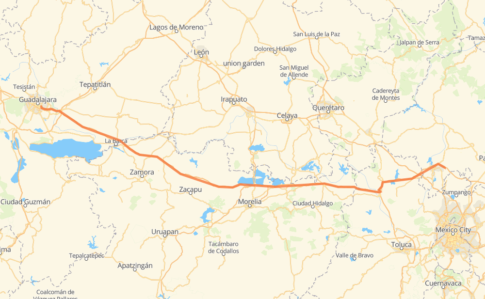
The distance from San Pedro Tlaquepaque to Tlalminulpa is 485 kilometers by road including 482 kilometers on motorways. Road takes approximately 5 hours and 22 minutes and goes through Tonalá, Vista Hermosa de Negrete, Ecuandureo, Panindicuaro, Huaniqueo de Morales, Maravatio and Pastores.
| Shortest distance by air | 431 km ✈️ |
| Car route length | 485 km 🚗 |
| Driving time | 5 h 22 min |
| Fuel amount | 38.8 L |
| Fuel cost | 76.5 CAD |
| Toll roads cost | 548 + ? MXN |
| Point | Distance | Time | Fuel | |
| San Pedro Tlaquepaque | 0 km | 00 min | 0.0 L | |
|
MEX 80 12 km, 08 min
|
||||
| Tonalá | 12 km | 08 min | 0.3 L | |
|
MEX 15D 36 km, 26 min
|
||||
| Coralillos | 48 km | 35 min | 2.1 L | |
|
MEX 15D 58 km, 42 min
|
||||
| Vista Hermosa de Negrete | 106 km | 1 h 18 min | 8.1 L | |
|
MEX 15D 28 km, 18 min
|
||||
| Ecuandureo | 134 km | 1 h 36 min | 10.4 L | |
|
MEX 15D 53 km, 36 min
|
||||
| Panindicuaro | 187 km | 2 h 12 min | 14.5 L | |
|
MEX 15D 30 km, 19 min
|
||||
| Huaniqueo de Morales | 217 km | 2 h 32 min | 17.1 L | |
|
MEX 15D 113 km, 1 h 08 min
|
||||
| Maravatio | 330 km | 3 h 40 min | 26.0 L | |
|
MEX 15D 116 km, 1 h 16 min
|
||||
| Jilotepec de Molina Enriquez | 445 km | 4 h 56 min | 35.2 L | |
|
MEX M40D 40 km, 25 min
|
||||
| Tlalminulpa | 485 km | 5 h 22 min | 38.8 L | |
Frequently Asked Questions
How many toll booths are there from San Pedro Tlaquepaque to Tlalminulpa?
There are 9 toll booths between San Pedro Tlaquepaque and Tlalminulpa: La Joya, Ocotlán, Zinapecuaro, Contepec, Panindicuaro, Ecuandureo, Atitalquia, Atlacomulco — Maravatio and Atlacomulco 2.
How much does the toll booths cost from San Pedro Tlaquepaque to Tlalminulpa?
Toll roads cost: La Joya (?) + Ocotlán (226 MXN) + Ecuandureo (111 MXN) + Panindicuaro (?) + Zinapecuaro (161 MXN) + Contepec (?) + Atlacomulco — Maravatio (50 MXN) + Atlacomulco 2 (?) + Atitalquia (?) = 548 + ? MXN
How much does it cost to drive from San Pedro Tlaquepaque to Tlalminulpa?
Fuel cost: 76.5 CAD
This fuel cost is calculated as: (Route length 485 km / 100 km) * (Fuel consumption 8 L/100 km) * (Fuel price 1.97 CAD / L)
You can adjust fuel consumption and fuel price here.
Toll roads cost: 548 + ? MXN
How long is a car ride from San Pedro Tlaquepaque to Tlalminulpa?
Driving time: 5 h 22 min
This time is calculated for driving at the maximum permitted speed, taking into account traffic rules restrictions.
- 41 km with a maximum speed 110 km/h = 22 min
- 222 km with a maximum speed 100 km/h = 2 h 13 min
- 2 km with a maximum speed 90 km/h = 1 min
- 219 km with a maximum speed 80 km/h = 2 h 44 min
- 1 km with a maximum speed 50 km/h = 1 min
The calculated driving time does not take into account intermediate stops and traffic jams.
How far is San Pedro Tlaquepaque to Tlalminulpa by land?
The distance between San Pedro Tlaquepaque and Tlalminulpa is 485 km by road including 482 km on motorways.
Precise satellite coordinates of highways were used for this calculation. The start and finish points are the centers of San Pedro Tlaquepaque and Tlalminulpa respectively.
How far is San Pedro Tlaquepaque to Tlalminulpa by plane?
The shortest distance (air line, as the crow flies) between San Pedro Tlaquepaque and Tlalminulpa is 431 km.
This distance is calculated using the Haversine formula as a great-circle distance between two points on the surface of a sphere. The start and finish points are the centers of San Pedro Tlaquepaque and Tlalminulpa respectively. Actual distance between airports may be different.
How many hours is San Pedro Tlaquepaque from Tlalminulpa by plane?
Boeing 737 airliner needs 32 min to cover the distance of 431 km at a cruising speed of 800 km/h.
Small plane "Cessna 172" needs 1 h 57 min to flight this distance at average speed of 220 km/h.
This time is approximate and do not take into account takeoff and landing times, airport location and other real world factors.
How long is a helicopter ride from San Pedro Tlaquepaque to Tlalminulpa?
Fast helicopter "Eurocopter AS350" or "Hughes OH-6 Cayuse" need 1 h 47 min to cover the distance of 431 km at a cruising speed of 240 km/h.
Popular "Robinson R44" needs 2 h 3 min to flight this distance at average speed of 210 km/h.
This time is approximate and do not take into account takeoff and landing times, aerodrome location and other real world factors.
What city is halfway between San Pedro Tlaquepaque and Tlalminulpa?
The halfway point between San Pedro Tlaquepaque and Tlalminulpa is Santa Rita. It is located about 3 km from the exact midpoint by road.
The distance from Santa Rita to San Pedro Tlaquepaque is 245 km and driving will take about 2 h 50 min. The road between Santa Rita and Tlalminulpa has length 240 km and will take approximately 2 h 32 min.
The other cities located close to halfway point:
Where is San Pedro Tlaquepaque in relation to Tlalminulpa?
San Pedro Tlaquepaque is located 431 km west of Tlalminulpa.
San Pedro Tlaquepaque has geographic coordinates: latitude 20.63965, longitude -103.31185.
Tlalminulpa has geographic coordinates: latitude 20.07222, longitude -99.22083.
Which highway goes from San Pedro Tlaquepaque to Tlalminulpa?
The route from San Pedro Tlaquepaque to Tlalminulpa follows MEX 15D.
Other minor sections pass along the road:
- MEX M40D: 81 km
- MEX 80D: 17 km
- MEX 040D: 6 km
- MEX 80: 2 km