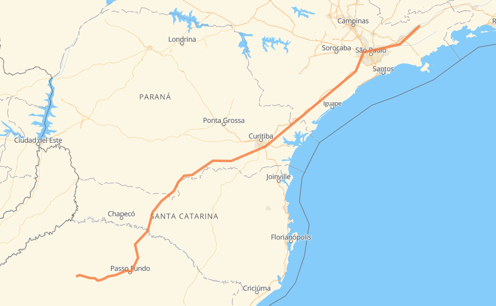
Distance between Salto and Bosque
The distance from Salto to Bosque is 1,264 kilometers by road including 596 kilometers on motorways. Road takes approximately 14 hours and 23 minutes and goes through Piraquara, Taboão da Serra, Jacareí and Pindamonhangaba.
| Shortest distance by air | 1,023 km ✈️ |
| Car route length | 1,264 km 🚗 |
| Driving time | 14 h 23 min |
| Fuel amount | 101.1 L |
| Fuel cost | 198.1 CAD |
| Point | Distance | Time | Fuel | |
| Salto | 0 km | 00 min | 0.0 L | |
|
BR-285 271 km, 3 h 24 min
|
||||
| Linha Água Verde | 271 km | 3 h 24 min | 21.0 L | |
|
BR-153 16 km, 11 min
|
||||
| Posto Cem | 286 km | 3 h 35 min | 22.4 L | |
|
BR-153 BR-476 397 km, 4 h 29 min
|
||||
| Ganchinho | 684 km | 8 h 05 min | 54.4 L | |
|
BR-116 26 km, 15 min
|
||||
| Piraquara | 710 km | 8 h 21 min | 56.2 L | |
|
BR-116 70 km, 51 min
|
||||
| Antonina | 780 km | 9 h 12 min | 61.0 L | |
|
BR-116 311 km, 3 h 13 min
|
||||
| Taboão da Serra | 1,091 km | 12 h 26 min | 87.2 L | |
|
SP-230 SP-070 114 km, 1 h 10 min
|
||||
| Jacareí | 1,205 km | 13 h 36 min | 96.1 L | |
|
SP-070 74 km, 44 min
|
||||
| Pindamonhangaba | 1,279 km | 14 h 21 min | 102.3 L | |
|
BR-383 2 km, 02 min
|
||||
| Bosque | 1,281 km | 14 h 23 min | 102.5 L | |
Frequently Asked Questions
How much does it cost to drive from Salto to Bosque?
Fuel cost: 198.1 CAD
This fuel cost is calculated as: (Route length 1,264 km / 100 km) * (Fuel consumption 8 L/100 km) * (Fuel price 1.96 CAD / L)
You can adjust fuel consumption and fuel price here.
How long is a car ride from Salto to Bosque?
Driving time: 14 h 23 min
This time is calculated for driving at the maximum permitted speed, taking into account traffic rules restrictions.
- 346 km with a maximum speed 110 km/h = 3 h 8 min
- 107 km with a maximum speed 100 km/h = 1 h 4 min
- 486 km with a maximum speed 90 km/h = 5 h 24 min
- 254 km with a maximum speed 80 km/h = 3 h 10 min
- 68 km with a maximum speed 60 km/h = 1 h 7 min
- 7 km with a maximum speed 50 km/h = 8 min
- 12 km with a maximum speed 40 km/h = 18 min
- 1 km with a maximum speed 30 km/h = 1 min
The calculated driving time does not take into account intermediate stops and traffic jams.
How far is Salto to Bosque by land?
The distance between Salto and Bosque is 1,264 km by road including 596 km on motorways.
Precise satellite coordinates of highways were used for this calculation. The start and finish points are the centers of Salto and Bosque respectively.
How far is Salto to Bosque by plane?
The shortest distance (air line, as the crow flies) between Salto and Bosque is 1,023 km.
This distance is calculated using the Haversine formula as a great-circle distance between two points on the surface of a sphere. The start and finish points are the centers of Salto and Bosque respectively. Actual distance between airports may be different.
How many hours is Salto from Bosque by plane?
Boeing 737 airliner needs 1 h 16 min to cover the distance of 1,023 km at a cruising speed of 800 km/h.
Small plane "Cessna 172" needs 4 h 39 min to flight this distance at average speed of 220 km/h.
This time is approximate and do not take into account takeoff and landing times, airport location and other real world factors.
How long is a helicopter ride from Salto to Bosque?
Fast helicopter "Eurocopter AS350" or "Hughes OH-6 Cayuse" need 4 h 15 min to cover the distance of 1,023 km at a cruising speed of 240 km/h.
Popular "Robinson R44" needs 4 h 52 min to flight this distance at average speed of 210 km/h.
This time is approximate and do not take into account takeoff and landing times, aerodrome location and other real world factors.
What city is halfway between Salto and Bosque?
The halfway point between Salto and Bosque is Ganchinho. It is located about 52 km from the exact midpoint by road.
The distance from Ganchinho to Salto is 684 km and driving will take about 8 h 5 min. The road between Ganchinho and Bosque has length 580 km and will take approximately 6 h 18 min.
The other cities located close to halfway point:
Where is Salto in relation to Bosque?
Salto is located 1,023 km south-west of Bosque.
Salto has geographic coordinates: latitude -28.35191, longitude -53.70227.
Bosque has geographic coordinates: latitude -22.92036, longitude -45.45824.
Which highway goes from Salto to Bosque?
The route from Salto to Bosque follows BR-116, SP-230, BR-153, BR-476, BR-285, SP-070.
Other minor sections pass along the road:
- ERS-135: 72 km
- BR-478: 48 km
- SP-015: 22 km
- BR-277: 22 km
- SP-060: 18 km
- BR-383: 18 km
- SP-021: 13 km
- BR-050: 7 km
- BR-374: 4 km
- SP-280: 4 km
- SPI 117/070: 3 km
- SPM-280 E: 2 km
- SPI-016/021: 2 km