Distance between São Mamede and Tuizelo
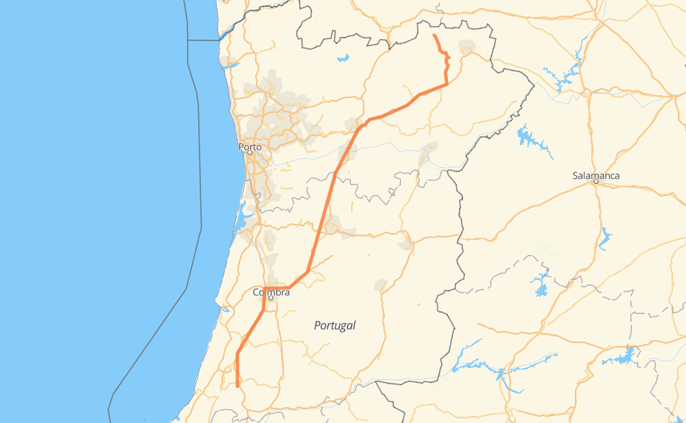
The distance from São Mamede to Tuizelo is 385 kilometers by road including 254 kilometers on motorways. Road takes approximately 4 hours and goes through Pousos, Condeixa-a-Nova, Ribeira de Frades, Taveiro, São Martinho do Bispo, Penacova and Almaça.
| Shortest distance by air | 289 km ✈️ |
| Car route length | 385 km 🚗 |
| Driving time | 4 h |
| Fuel amount | 30.8 L |
| Fuel cost | 60.3 CAD |
| Point | Distance | Time | Fuel | |
| São Mamede | 0 km | 00 min | 0.0 L | |
|
A 1 18 km, 12 min
|
||||
| Pousos | 18 km | 12 min | 1.3 L | |
|
A 1 53 km, 28 min
|
||||
| Condeixa-a-Nova | 71 km | 40 min | 5.6 L | |
|
A 1 6 km, 03 min
|
||||
| Ribeira de Frades | 77 km | 44 min | 5.8 L | |
|
A 1 6 km, 03 min
|
||||
| São Martinho do Bispo | 82 km | 47 min | 6.5 L | |
|
A 1 IP 3 27 km, 18 min
|
||||
| Penacova | 110 km | 1 h 05 min | 8.7 L | |
|
IP 3 12 km, 08 min
|
||||
| Almaça | 121 km | 1 h 13 min | 9.5 L | |
|
IP 3 14 km, 09 min
|
||||
| Santa Comba Dão | 135 km | 1 h 23 min | 10.6 L | |
|
IP 3 13 km, 09 min
|
||||
| Tondela | 148 km | 1 h 32 min | 11.6 L | |
|
IP 3 A 24 237 km, 2 h 27 min
|
||||
| Tuizelo | 385 km | 3 h 59 min | 30.6 L | |
Frequently Asked Questions
How much does it cost to drive from São Mamede to Tuizelo?
Fuel cost: 60.3 CAD
This fuel cost is calculated as: (Route length 385 km / 100 km) * (Fuel consumption 8 L/100 km) * (Fuel price 1.96 CAD / L)
You can adjust fuel consumption and fuel price here.
How long is a car ride from São Mamede to Tuizelo?
Driving time: 4 h
This time is calculated for driving at the maximum permitted speed, taking into account traffic rules restrictions.
- 205 km with a maximum speed 110 km/h = 1 h 51 min
- 27 km with a maximum speed 100 km/h = 16 min
- 58 km with a maximum speed 90 km/h = 38 min
- 89 km with a maximum speed 80 km/h = 1 h 6 min
- 5 km with a maximum speed 50 km/h = 6 min
The calculated driving time does not take into account intermediate stops and traffic jams.
How far is São Mamede to Tuizelo by land?
The distance between São Mamede and Tuizelo is 385 km by road including 254 km on motorways.
Precise satellite coordinates of highways were used for this calculation. The start and finish points are the centers of São Mamede and Tuizelo respectively.
How far is São Mamede to Tuizelo by plane?
The shortest distance (air line, as the crow flies) between São Mamede and Tuizelo is 289 km.
This distance is calculated using the Haversine formula as a great-circle distance between two points on the surface of a sphere. The start and finish points are the centers of São Mamede and Tuizelo respectively. Actual distance between airports may be different.
How many hours is São Mamede from Tuizelo by plane?
Boeing 737 airliner needs 21 min to cover the distance of 289 km at a cruising speed of 800 km/h.
Small plane "Cessna 172" needs 1 h 18 min to flight this distance at average speed of 220 km/h.
This time is approximate and do not take into account takeoff and landing times, airport location and other real world factors.
How long is a helicopter ride from São Mamede to Tuizelo?
Fast helicopter "Eurocopter AS350" or "Hughes OH-6 Cayuse" need 1 h 12 min to cover the distance of 289 km at a cruising speed of 240 km/h.
Popular "Robinson R44" needs 1 h 22 min to flight this distance at average speed of 210 km/h.
This time is approximate and do not take into account takeoff and landing times, aerodrome location and other real world factors.
What city is halfway between São Mamede and Tuizelo?
The halfway point between São Mamede and Tuizelo is Vilar do Monte. It is located about 7 km from the exact midpoint by road.
The distance from Vilar do Monte to São Mamede is 185 km and driving will take about 1 h 55 min. The road between Vilar do Monte and Tuizelo has length 200 km and will take approximately 2 h 4 min.
The other cities located close to halfway point:
Where is São Mamede in relation to Tuizelo?
São Mamede is located 289 km south-west of Tuizelo.
São Mamede has geographic coordinates: latitude 39.62275, longitude -8.71721.
Tuizelo has geographic coordinates: latitude 41.89484, longitude -7.05463.