Distance between Rosthern SK and Gillam MB
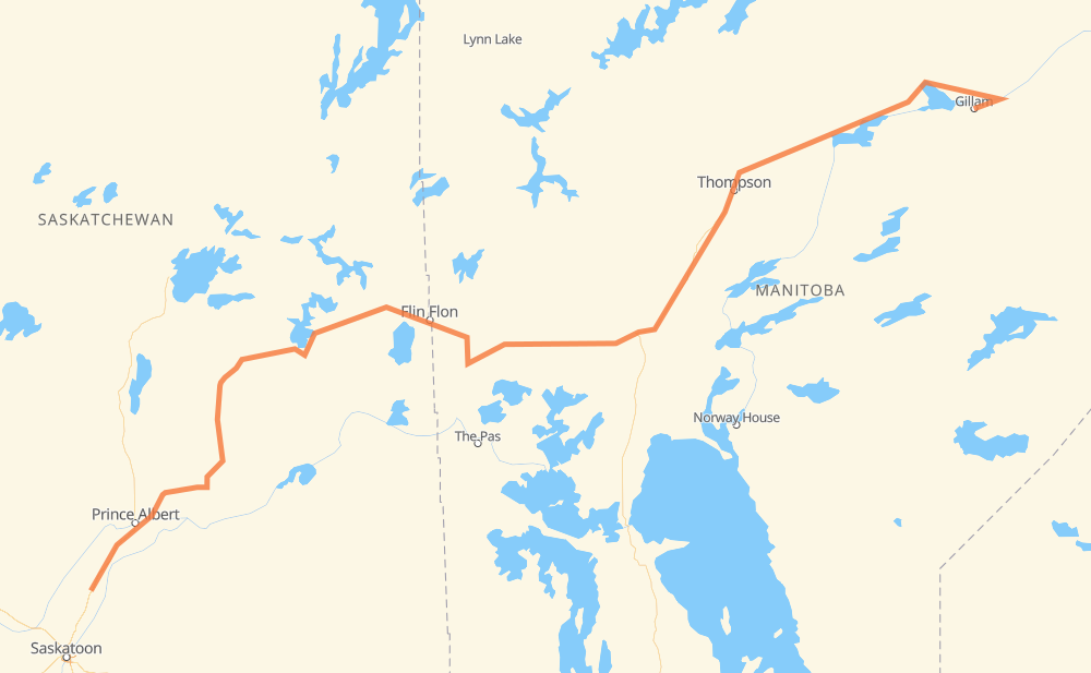
The distance from Rosthern to Gillam is 1,166 kilometers by road. Road takes approximately 13 hours and 10 minutes and goes through Prince Albert, Flin Flon, Thompson, Duck Lake, Snow Lake and Wabowden.
| Shortest distance by air | 854 km ✈️ |
| Car route length | 1,166 km 🚗 |
| Driving time | 13 h 10 min |
| Fuel amount | 93.2 L |
| Fuel cost | 182.8 CAD |
| Point | Distance | Time | Fuel | |
| Rosthern | 0 km | 00 min | 0.0 L | |
|
11 81 km, 55 min
|
||||
| Prince Albert | 81 km | 55 min | 5.5 L | |
|
55 28 km, 19 min
|
||||
| Meath Park | 109 km | 1 h 14 min | 8.0 L | |
|
55 28 km, 18 min
|
||||
| Foxford | 136 km | 1 h 32 min | 9.5 L | |
|
55 106 342 km, 3 h 49 min
|
||||
| Flin Flon | 478 km | 5 h 22 min | 37.7 L | |
|
106 PTH 10 51 km, 34 min
|
||||
| Cranberry Portage | 530 km | 5 h 56 min | 42.3 L | |
|
PTH 10 PTH 39 116 km, 1 h 18 min
|
||||
| Snow Lake | 645 km | 7 h 15 min | 50.1 L | |
|
PTH 39 111 km, 1 h 16 min
|
||||
| Wabowden | 756 km | 8 h 31 min | 59.8 L | |
|
PTH 6 108 km, 1 h 12 min
|
||||
| Thompson | 864 km | 9 h 44 min | 68.9 L | |
|
PR 391 PR 280 301 km, 3 h 25 min
|
||||
| Gillam | 1,166 km | 13 h 10 min | 89.9 L | |
Hotels of Gillam
Frequently Asked Questions
How much does it cost to drive from Rosthern to Gillam?
Fuel cost: 182.8 CAD
This fuel cost is calculated as: (Route length 1,166 km / 100 km) * (Fuel consumption 8 L/100 km) * (Fuel price 1.96 CAD / L)
You can adjust fuel consumption and fuel price here.
How long is a car ride from Rosthern to Gillam?
Driving time: 13 h 10 min
This time is calculated for driving at the maximum permitted speed, taking into account traffic rules restrictions.
- 1,035 km with a maximum speed 90 km/h = 11 h 29 min
- 126 km with a maximum speed 80 km/h = 1 h 34 min
- 1 km with a maximum speed 60 km/h = 1 min
- 3 km with a maximum speed 50 km/h = 3 min
- 1 km with a maximum speed 40 km/h = 1 min
The calculated driving time does not take into account intermediate stops and traffic jams.
How far is Rosthern to Gillam by land?
The distance between Rosthern and Gillam is 1,166 km by road.
Precise satellite coordinates of highways were used for this calculation. The start and finish points are the centers of Rosthern and Gillam respectively.
How far is Rosthern to Gillam by plane?
The shortest distance (air line, as the crow flies) between Rosthern and Gillam is 854 km.
This distance is calculated using the Haversine formula as a great-circle distance between two points on the surface of a sphere. The start and finish points are the centers of Rosthern and Gillam respectively. Actual distance between airports may be different.
How many hours is Rosthern from Gillam by plane?
Boeing 737 airliner needs 1 h 4 min to cover the distance of 854 km at a cruising speed of 800 km/h.
Small plane "Cessna 172" needs 3 h 52 min to flight this distance at average speed of 220 km/h.
This time is approximate and do not take into account takeoff and landing times, airport location and other real world factors.
How long is a helicopter ride from Rosthern to Gillam?
Fast helicopter "Eurocopter AS350" or "Hughes OH-6 Cayuse" need 3 h 33 min to cover the distance of 854 km at a cruising speed of 240 km/h.
Popular "Robinson R44" needs 4 h 4 min to flight this distance at average speed of 210 km/h.
This time is approximate and do not take into account takeoff and landing times, aerodrome location and other real world factors.
What city is halfway between Rosthern and Gillam?
The halfway point between Rosthern and Gillam is Cranberry Portage. It is located about 53 km from the exact midpoint by road.
The distance from Cranberry Portage to Rosthern is 530 km and driving will take about 5 h 56 min. The road between Cranberry Portage and Gillam has length 636 km and will take approximately 7 h 13 min.
The other cities located close to halfway point:
Where is Rosthern in relation to Gillam?
Rosthern is located 854 km south-west of Gillam.
Rosthern has geographic coordinates: latitude 52.66389, longitude -106.3353.
Gillam has geographic coordinates: latitude 56.34544, longitude -94.70768.
Which highway goes from Rosthern to Gillam?
The route from Rosthern to Gillam follows 106, PR 280, PTH 39, PTH 6.
Other minor sections pass along the road:
- 55: 78 km
- 11: 67 km
- PTH 10: 61 km
- PR 391: 12 km
- 2: 7 km
- PTH 10A: 3 km
- 167: 2 km