Distance between Rio Pardo de Minas and Itaperuna
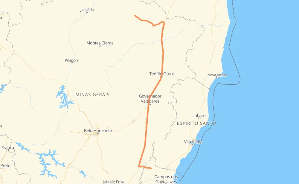
The distance from Rio Pardo de Minas to Itaperuna is 892 kilometers by road. Road takes approximately 10 hours and 52 minutes and goes through Muriaé, Centro, Medina, Itaobim, Ponto dos Volantes, Padre Paraíso and Itambacuri.
| Shortest distance by air | 625 km ✈️ |
| Car route length | 892 km 🚗 |
| Driving time | 10 h 52 min |
| Fuel amount | 71.4 L |
| Fuel cost | 139.9 CAD |
| Point | Distance | Time | Fuel | |
| Rio Pardo de Minas | 0 km | 00 min | 0.0 L | |
|
LMG-629 LMG-626 48 km, 36 min
|
||||
| Centro | 48 km | 36 min | 3.8 L | |
|
BR-251 156 km, 1 h 52 min
|
||||
| Medina | 204 km | 2 h 28 min | 13.4 L | |
|
BR-116 48 km, 32 min
|
||||
| Itaobim | 252 km | 3 h 01 min | 19.2 L | |
|
BR-116 24 km, 17 min
|
||||
| Ponto dos Volantes | 276 km | 3 h 19 min | 21.0 L | |
|
BR-116 28 km, 19 min
|
||||
| Padre Paraíso | 304 km | 3 h 39 min | 23.2 L | |
|
BR-116 132 km, 1 h 40 min
|
||||
| Itambacuri | 436 km | 5 h 19 min | 34.4 L | |
|
BR-116 101 km, 1 h 14 min
|
||||
| Santa Paula | 537 km | 6 h 34 min | 42.9 L | |
|
BR-116 11 km, 08 min
|
||||
| Azteca | 548 km | 6 h 42 min | 43.8 L | |
|
BR-116 291 km, 3 h 32 min
|
||||
| Muriaé | 839 km | 10 h 14 min | 65.7 L | |
|
BR-356 54 km, 37 min
|
||||
| -21.20480, -41.88801 | 893 km | 10 h 52 min | 71.5 L | |
Hotels of Itaperuna
Frequently Asked Questions
How much does it cost to drive from Rio Pardo de Minas to Itaperuna?
Fuel cost: 139.9 CAD
This fuel cost is calculated as: (Route length 892 km / 100 km) * (Fuel consumption 8 L/100 km) * (Fuel price 1.96 CAD / L)
You can adjust fuel consumption and fuel price here.
How long is a car ride from Rio Pardo de Minas to Itaperuna?
Driving time: 10 h 52 min
This time is calculated for driving at the maximum permitted speed, taking into account traffic rules restrictions.
- 390 km with a maximum speed 90 km/h = 4 h 20 min
- 468 km with a maximum speed 80 km/h = 5 h 51 min
- 20 km with a maximum speed 60 km/h = 20 min
- 2 km with a maximum speed 50 km/h = 2 min
- 12 km with a maximum speed 40 km/h = 18 min
The calculated driving time does not take into account intermediate stops and traffic jams.
How far is Rio Pardo de Minas to Itaperuna by land?
The distance between Rio Pardo de Minas and Itaperuna is 892 km by road.
Precise satellite coordinates of highways were used for this calculation. The start and finish points are the centers of Rio Pardo de Minas and Itaperuna respectively.
How far is Rio Pardo de Minas to Itaperuna by plane?
The shortest distance (air line, as the crow flies) between Rio Pardo de Minas and Itaperuna is 625 km.
This distance is calculated using the Haversine formula as a great-circle distance between two points on the surface of a sphere. The start and finish points are the centers of Rio Pardo de Minas and Itaperuna respectively. Actual distance between airports may be different.
How many hours is Rio Pardo de Minas from Itaperuna by plane?
Boeing 737 airliner needs 46 min to cover the distance of 625 km at a cruising speed of 800 km/h.
Small plane "Cessna 172" needs 2 h 50 min to flight this distance at average speed of 220 km/h.
This time is approximate and do not take into account takeoff and landing times, airport location and other real world factors.
How long is a helicopter ride from Rio Pardo de Minas to Itaperuna?
Fast helicopter "Eurocopter AS350" or "Hughes OH-6 Cayuse" need 2 h 36 min to cover the distance of 625 km at a cruising speed of 240 km/h.
Popular "Robinson R44" needs 2 h 58 min to flight this distance at average speed of 210 km/h.
This time is approximate and do not take into account takeoff and landing times, aerodrome location and other real world factors.
What city is halfway between Rio Pardo de Minas and Itaperuna?
The halfway point between Rio Pardo de Minas and Itaperuna is Campanário. It is located about 10 km from the exact midpoint by road.
The distance from Campanário to Rio Pardo de Minas is 456 km and driving will take about 5 h 34 min. The road between Campanário and Itaperuna has length 436 km and will take approximately 5 h 18 min.
The other cities located close to halfway point:
Where is Rio Pardo de Minas in relation to Itaperuna?
Rio Pardo de Minas is located 625 km north of Itaperuna.
Rio Pardo de Minas has geographic coordinates: latitude -15.62033, longitude -42.54539.
Itaperuna has geographic coordinates: latitude -21.2048, longitude -41.88801.
Which highway goes from Rio Pardo de Minas to Itaperuna?
The route from Rio Pardo de Minas to Itaperuna follows BR-116.
Other minor sections pass along the road:
- BR-342: 71 km
- BR-251: 67 km
- BR-356: 58 km
- LMG-626: 52 km
- LMG-629: 42 km