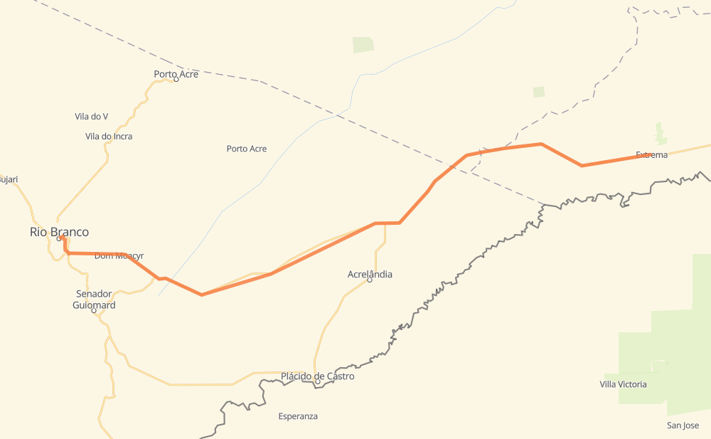
Distance between Rio Branco and Extrema
The distance from Rio Branco to Extrema is 183 kilometers by road. Road takes approximately 2 hours and 17 minutes and goes through Santa Cecilia, Albert Sampaio, Dom Moacyr and Vila Nova Aldeia.
| Shortest distance by air | 162 km ✈️ |
| Car route length | 183 km 🚗 |
| Driving time | 2 h 17 min |
| Fuel amount | 14.6 L |
| Fuel cost | 28.6 CAD |
| Point | Distance | Time | Fuel | |
| Rio Branco | 0 km | 00 min | 0.0 L | |
|
BR-364 21 km, 16 min
|
||||
| Santa Cecilia | 21 km | 16 min | 0.8 L | |
|
BR-364 30 km, 22 min
|
||||
| Fazenda Laredo | 52 km | 39 min | 3.0 L | |
|
BR-364 32 km, 23 min
|
||||
| Deixa-Falar | 83 km | 1 h 02 min | 5.3 L | |
|
BR-364 28 km, 20 min
|
||||
| Seringal Novo Acordo | 111 km | 1 h 23 min | 8.0 L | |
|
BR-364 11 km, 07 min
|
||||
| Colonia Oito de Maio | 122 km | 1 h 31 min | 9.7 L | |
|
BR-364 61 km, 45 min
|
||||
| Extrema | 183 km | 2 h 17 min | 10.0 L | |
Frequently Asked Questions
How much does it cost to drive from Rio Branco to Extrema?
Fuel cost: 28.6 CAD
This fuel cost is calculated as: (Route length 183 km / 100 km) * (Fuel consumption 8 L/100 km) * (Fuel price 1.96 CAD / L)
You can adjust fuel consumption and fuel price here.
How long is a car ride from Rio Branco to Extrema?
Driving time: 2 h 17 min
This time is calculated for driving at the maximum permitted speed, taking into account traffic rules restrictions.
- 3 km with a maximum speed 90 km/h = 2 min
- 178 km with a maximum speed 80 km/h = 2 h 13 min
- 1 km with a maximum speed 50 km/h = 1 min
The calculated driving time does not take into account intermediate stops and traffic jams.
How far is Rio Branco to Extrema by land?
The distance between Rio Branco and Extrema is 183 km by road.
Precise satellite coordinates of highways were used for this calculation. The start and finish points are the centers of Rio Branco and Extrema respectively.
How far is Rio Branco to Extrema by plane?
The shortest distance (air line, as the crow flies) between Rio Branco and Extrema is 162 km.
This distance is calculated using the Haversine formula as a great-circle distance between two points on the surface of a sphere. The start and finish points are the centers of Rio Branco and Extrema respectively. Actual distance between airports may be different.
How many hours is Rio Branco from Extrema by plane?
Boeing 737 airliner needs 12 min to cover the distance of 162 km at a cruising speed of 800 km/h.
Small plane "Cessna 172" needs 44 min to flight this distance at average speed of 220 km/h.
This time is approximate and do not take into account takeoff and landing times, airport location and other real world factors.
How long is a helicopter ride from Rio Branco to Extrema?
Fast helicopter "Eurocopter AS350" or "Hughes OH-6 Cayuse" need 40 min to cover the distance of 162 km at a cruising speed of 240 km/h.
Popular "Robinson R44" needs 46 min to flight this distance at average speed of 210 km/h.
This time is approximate and do not take into account takeoff and landing times, aerodrome location and other real world factors.
What city is halfway between Rio Branco and Extrema?
The halfway point between Rio Branco and Extrema is Deixa-Falar. It is located about 8 km from the exact midpoint by road.
The distance from Deixa-Falar to Rio Branco is 83 km and driving will take about 1 h 2 min. The road between Deixa-Falar and Extrema has length 99 km and will take approximately 1 h 14 min.
The other cities located close to halfway point:
Where is Rio Branco in relation to Extrema?
Rio Branco is located 162 km west of Extrema.
Rio Branco has geographic coordinates: latitude -9.97654, longitude -67.82208.
Extrema has geographic coordinates: latitude -9.77115, longitude -66.35512.
Which highway goes from Rio Branco to Extrema?
The route from Rio Branco to Extrema follows BR-364.