Distance between Rincão dos Ilhéus and São Carlos
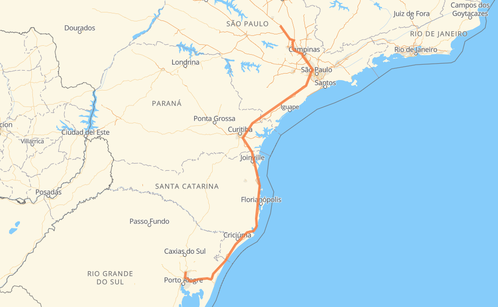
The distance from Rincão dos Ilhéus to São Carlos is 1,370 kilometers by road including 1,356 kilometers on motorways. Road takes approximately 14 hours and 18 minutes and goes through Novo Hamburgo, Piraquara, Taboão da Serra, Barueri and Rio Claro.
| Shortest distance by air | 911 km ✈️ |
| Car route length | 1,370 km 🚗 |
| Driving time | 14 h 18 min |
| Fuel amount | 109.6 L |
| Fuel cost | 214.7 CAD |
| Point | Distance | Time | Fuel | |
| Rincão dos Ilhéus | 0 km | 00 min | 0.0 L | |
|
3 km, 03 min
|
||||
| Novo Hamburgo | 3 km | 03 min | 0.1 L | |
|
BR-116 13 km, 10 min
|
||||
| São João Batista | 16 km | 13 min | 1.1 L | |
|
BR-116 ERS-118 12 km, 08 min
|
||||
| Três Marias | 28 km | 22 min | 2.1 L | |
|
ERS-118 BR-101 201 km, 2 h 00 min
|
||||
| Glorinha | 229 km | 2 h 22 min | 18.2 L | |
|
BR-101 527 km, 5 h 22 min
|
||||
| Piraquara | 756 km | 7 h 45 min | 59.9 L | |
|
BR-116 381 km, 4 h 05 min
|
||||
| Taboão da Serra | 1,137 km | 11 h 50 min | 90.9 L | |
|
SP-230 SP-021 18 km, 11 min
|
||||
| Barueri | 1,155 km | 12 h 01 min | 92.2 L | |
|
SP-021 SP-348 173 km, 1 h 39 min
|
||||
| Rio Claro | 1,328 km | 13 h 41 min | 105.8 L | |
|
SP-310 59 km, 37 min
|
||||
| São Carlos | 1,387 km | 14 h 18 min | 110.9 L | |
Hotels of São Carlos
Frequently Asked Questions
How much does it cost to drive from Rincão dos Ilhéus to São Carlos?
Fuel cost: 214.7 CAD
This fuel cost is calculated as: (Route length 1,370 km / 100 km) * (Fuel consumption 8 L/100 km) * (Fuel price 1.96 CAD / L)
You can adjust fuel consumption and fuel price here.
How long is a car ride from Rincão dos Ilhéus to São Carlos?
Driving time: 14 h 18 min
This time is calculated for driving at the maximum permitted speed, taking into account traffic rules restrictions.
- 724 km with a maximum speed 110 km/h = 6 h 35 min
- 405 km with a maximum speed 100 km/h = 4 h 2 min
- 24 km with a maximum speed 90 km/h = 16 min
- 143 km with a maximum speed 80 km/h = 1 h 47 min
- 78 km with a maximum speed 60 km/h = 1 h 17 min
- 1 km with a maximum speed 50 km/h = 1 min
- 12 km with a maximum speed 40 km/h = 17 min
The calculated driving time does not take into account intermediate stops and traffic jams.
How far is Rincão dos Ilhéus to São Carlos by land?
The distance between Rincão dos Ilhéus and São Carlos is 1,370 km by road including 1,356 km on motorways.
Precise satellite coordinates of highways were used for this calculation. The start and finish points are the centers of Rincão dos Ilhéus and São Carlos respectively.
How far is Rincão dos Ilhéus to São Carlos by plane?
The shortest distance (air line, as the crow flies) between Rincão dos Ilhéus and São Carlos is 911 km.
This distance is calculated using the Haversine formula as a great-circle distance between two points on the surface of a sphere. The start and finish points are the centers of Rincão dos Ilhéus and São Carlos respectively. Actual distance between airports may be different.
How many hours is Rincão dos Ilhéus from São Carlos by plane?
Boeing 737 airliner needs 1 h 8 min to cover the distance of 911 km at a cruising speed of 800 km/h.
Small plane "Cessna 172" needs 4 h 8 min to flight this distance at average speed of 220 km/h.
This time is approximate and do not take into account takeoff and landing times, airport location and other real world factors.
How long is a helicopter ride from Rincão dos Ilhéus to São Carlos?
Fast helicopter "Eurocopter AS350" or "Hughes OH-6 Cayuse" need 3 h 47 min to cover the distance of 911 km at a cruising speed of 240 km/h.
Popular "Robinson R44" needs 4 h 20 min to flight this distance at average speed of 210 km/h.
This time is approximate and do not take into account takeoff and landing times, aerodrome location and other real world factors.
What city is halfway between Rincão dos Ilhéus and São Carlos?
The halfway point between Rincão dos Ilhéus and São Carlos is Distrito Industrial Sul. It is located about 27 km from the exact midpoint by road.
The distance from Distrito Industrial Sul to Rincão dos Ilhéus is 658 km and driving will take about 6 h 37 min. The road between Distrito Industrial Sul and São Carlos has length 711 km and will take approximately 7 h 41 min.
The other cities located close to halfway point:
Where is Rincão dos Ilhéus in relation to São Carlos?
Rincão dos Ilhéus is located 911 km south-west of São Carlos.
Rincão dos Ilhéus has geographic coordinates: latitude -29.66294, longitude -51.14915.
São Carlos has geographic coordinates: latitude -22.01834, longitude -47.89093.
Which highway goes from Rincão dos Ilhéus to São Carlos?
The route from Rincão dos Ilhéus to São Carlos follows BR-101, BR-116, SP-230, SP-348.
Other minor sections pass along the road:
- BR-290: 74 km
- BR-376: 74 km
- SP-310: 73 km
- BR-364: 72 km
- BR-478: 48 km
- SP-021: 25 km
- ERS-118: 22 km
- BR-285: 9 km
- BR-277: 9 km
- RS-118: 3 km