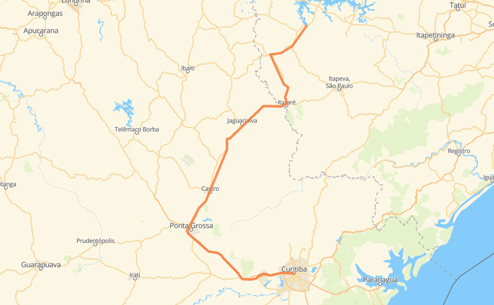
Distance between Porto Taquari and Curitiba
The distance from Porto Taquari to Curitiba is 390 kilometers by road including 104 kilometers on motorways. Road takes approximately 4 hours and 25 minutes and goes through Campo Largo, Jardim Ouro Branco, Itaporanga, Bairro dos Lajes, Bairro do Rola-Burro, Bairro da Conceição and Bairro da Serrinha.
| Shortest distance by air | 217 km ✈️ |
| Car route length | 390 km 🚗 |
| Driving time | 4 h 25 min |
| Fuel amount | 31.2 L |
| Fuel cost | 61.2 CAD |
| Point | Distance | Time | Fuel | |
| Porto Taquari | 0 km | 00 min | 0.0 L | |
|
SP-255 10 km, 07 min
|
||||
| Jardim Ouro Branco | 10 km | 07 min | 0.8 L | |
|
SP-255 35 km, 24 min
|
||||
| Itaporanga | 45 km | 32 min | 2.3 L | |
|
SP-255 19 km, 13 min
|
||||
| Bairro do Rola-Burro | 64 km | 46 min | 4.9 L | |
|
SP-281 17 km, 12 min
|
||||
| Bairro da Serrinha | 81 km | 59 min | 5.3 L | |
|
SP-281 24 km, 17 min
|
||||
| Jardim Regina | 105 km | 1 h 17 min | 8.2 L | |
|
SP-258 PR-239 24 km, 17 min
|
||||
| Centro | 129 km | 1 h 34 min | 9.5 L | |
|
PR-151 145 km, 1 h 38 min
|
||||
| Praça do Jardim Canaã | 274 km | 3 h 12 min | 21.7 L | |
|
BR-376 88 km, 51 min
|
||||
| Campo Largo | 362 km | 4 h 04 min | 28.4 L | |
|
BR-277 28 km, 20 min
|
||||
| Curitiba | 390 km | 4 h 24 min | 31.2 L | |
Hotels of Curitiba
Frequently Asked Questions
How much does it cost to drive from Porto Taquari to Curitiba?
Fuel cost: 61.2 CAD
This fuel cost is calculated as: (Route length 390 km / 100 km) * (Fuel consumption 8 L/100 km) * (Fuel price 1.96 CAD / L)
You can adjust fuel consumption and fuel price here.
How long is a car ride from Porto Taquari to Curitiba?
Driving time: 4 h 25 min
This time is calculated for driving at the maximum permitted speed, taking into account traffic rules restrictions.
- 85 km with a maximum speed 110 km/h = 46 min
- 171 km with a maximum speed 90 km/h = 1 h 53 min
- 124 km with a maximum speed 80 km/h = 1 h 33 min
- 5 km with a maximum speed 60 km/h = 5 min
- 1 km with a maximum speed 50 km/h = 1 min
- 3 km with a maximum speed 40 km/h = 4 min
The calculated driving time does not take into account intermediate stops and traffic jams.
How far is Porto Taquari to Curitiba by land?
The distance between Porto Taquari and Curitiba is 390 km by road including 104 km on motorways.
Precise satellite coordinates of highways were used for this calculation. The start and finish points are the centers of Porto Taquari and Curitiba respectively.
How far is Porto Taquari to Curitiba by plane?
The shortest distance (air line, as the crow flies) between Porto Taquari and Curitiba is 217 km.
This distance is calculated using the Haversine formula as a great-circle distance between two points on the surface of a sphere. The start and finish points are the centers of Porto Taquari and Curitiba respectively. Actual distance between airports may be different.
How many hours is Porto Taquari from Curitiba by plane?
Boeing 737 airliner needs 16 min to cover the distance of 217 km at a cruising speed of 800 km/h.
Small plane "Cessna 172" needs 59 min to flight this distance at average speed of 220 km/h.
This time is approximate and do not take into account takeoff and landing times, airport location and other real world factors.
How long is a helicopter ride from Porto Taquari to Curitiba?
Fast helicopter "Eurocopter AS350" or "Hughes OH-6 Cayuse" need 54 min to cover the distance of 217 km at a cruising speed of 240 km/h.
Popular "Robinson R44" needs 1 h 2 min to flight this distance at average speed of 210 km/h.
This time is approximate and do not take into account takeoff and landing times, aerodrome location and other real world factors.
What city is halfway between Porto Taquari and Curitiba?
The halfway point between Porto Taquari and Curitiba is Tijuco. It is located about 16 km from the exact midpoint by road.
The distance from Tijuco to Porto Taquari is 211 km and driving will take about 2 h 30 min. The road between Tijuco and Curitiba has length 179 km and will take approximately 1 h 54 min.
The other cities located close to halfway point:
Where is Porto Taquari in relation to Curitiba?
Porto Taquari is located 217 km north of Curitiba.
Porto Taquari has geographic coordinates: latitude -23.47923, longitude -49.16062.
Curitiba has geographic coordinates: latitude -25.4296, longitude -49.27127.
Which highway goes from Porto Taquari to Curitiba?
The route from Porto Taquari to Curitiba follows PR-151.
Other minor sections pass along the road:
- BR-376: 67 km
- SP-281: 54 km
- SP-255: 48 km
- BR-272: 48 km
- BR-277: 47 km
- PR-239: 12 km
- PRC-373: 8 km
- PR 151: 3 km