Distance between Portland ON and Vancouver BC
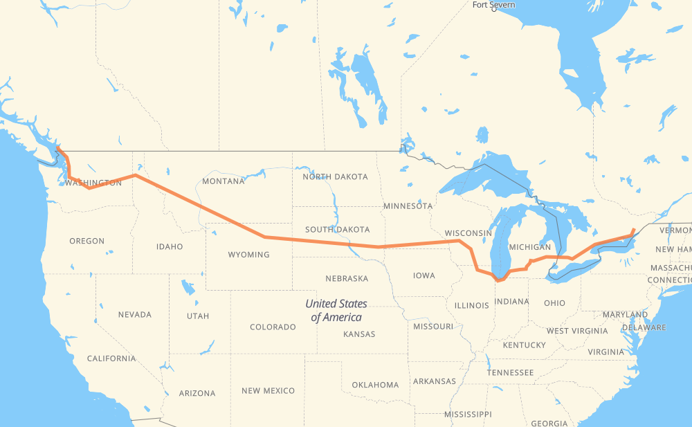
The distance from Portland to Vancouver is 4,737 kilometers by road including 4,642 kilometers on motorways. Road takes approximately 44 hours and 44 minutes and goes through Kingston, Belleville, Oshawa, Ajax, Toronto, Mississauga and Kitchener.
| Shortest distance by air | 3,539 km ✈️ |
| Car route length | 4,737 km 🚗 |
| Driving time | 44 h 44 min |
| Fuel amount | 379 L |
| Fuel cost | 742.8 CAD |
| Point | Distance | Time | Fuel | |
| Portland | 0 km | 00 min | 0.0 L | |
|
15 54 km, 38 min
|
||||
| Kingston | 54 km | 38 min | 2.3 L | |
|
15 401 83 km, 52 min
|
||||
| Belleville | 137 km | 1 h 31 min | 10.1 L | |
|
401 126 km, 1 h 15 min
|
||||
| Oshawa | 263 km | 2 h 46 min | 20.7 L | |
|
401 15 km, 08 min
|
||||
| Ajax | 277 km | 2 h 55 min | 22.0 L | |
|
401 32 km, 19 min
|
||||
| Toronto | 309 km | 3 h 14 min | 23.0 L | |
|
401 31 km, 18 min
|
||||
| Mississauga | 340 km | 3 h 32 min | 26.4 L | |
|
401 66 km, 39 min
|
||||
| Kitchener | 406 km | 4 h 12 min | 32.2 L | |
|
401 42 km, 25 min
|
||||
| Woodstock | 448 km | 4 h 37 min | 35.4 L | |
|
401 402 140 km, 1 h 19 min
|
||||
| Sarnia | 588 km | 5 h 57 min | 46.3 L | |
|
402 I 69 122 km, 1 h 12 min
|
||||
| Flint | 710 km | 7 h 10 min | 56.4 L | |
|
I 69 99 km, 53 min
|
||||
| Lansing | 809 km | 8 h 04 min | 64.5 L | |
|
I 69 102 km, 55 min
|
||||
| Kalamazoo | 910 km | 8 h 59 min | 72.6 L | |
|
I 94 I 90 409 km, 3 h 53 min
|
||||
| Janesville | 1,320 km | 12 h 53 min | 105.3 L | |
|
I 39 56 km, 30 min
|
||||
| Madison | 1,376 km | 13 h 23 min | 109.3 L | |
|
I 39 I 90 677 km, 6 h 09 min
|
||||
| Brandon | 2,053 km | 19 h 33 min | 163.9 L | |
|
I 90 11 km, 06 min
|
||||
| Sioux Falls | 2,064 km | 19 h 39 min | 164.8 L | |
|
I 90 116 km, 1 h 03 min
|
||||
| Mitchell | 2,180 km | 20 h 43 min | 173.2 L | |
|
I 90 411 km, 3 h 44 min
|
||||
| Box Elder | 2,591 km | 24 h 27 min | 206.5 L | |
|
I 90 19 km, 10 min
|
||||
| Rapid City | 2,610 km | 24 h 37 min | 208.5 L | |
|
I 90 68 km, 36 min
|
||||
| Spearfish | 2,678 km | 25 h 14 min | 213.3 L | |
|
I 90 156 km, 1 h 29 min
|
||||
| Gillette | 2,833 km | 26 h 44 min | 226.1 L | |
|
I 90 160 km, 1 h 34 min
|
||||
| Sheridan | 2,993 km | 28 h 19 min | 238.5 L | |
|
I 90 216 km, 2 h 02 min
|
||||
| Billings | 3,209 km | 30 h 21 min | 256.1 L | |
|
I 90 363 km, 3 h 19 min
|
||||
| Butte | 3,573 km | 33 h 41 min | 283.9 L | |
|
I 90 185 km, 1 h 40 min
|
||||
| Missoula | 3,757 km | 35 h 22 min | 300.3 L | |
|
I 90 265 km, 2 h 27 min
|
||||
| Coeur d'Alene | 4,023 km | 37 h 50 min | 321.3 L | |
|
I 90 55 km, 31 min
|
||||
| Spokane | 4,077 km | 38 h 21 min | 325.5 L | |
|
I 90 179 km, 1 h 37 min
|
||||
| Moses Lake | 4,256 km | 39 h 59 min | 338.6 L | |
|
I 90 254 km, 2 h 20 min
|
||||
| Bellevue | 4,510 km | 42 h 20 min | 360.2 L | |
|
I 405 45 km, 28 min
|
||||
| Everett | 4,555 km | 42 h 48 min | 363.7 L | |
|
I 5 95 km, 54 min
|
||||
| Bellingham | 4,649 km | 43 h 43 min | 370.9 L | |
|
I 5 99 90 km, 1 h 00 min
|
||||
| Vancouver | 4,739 km | 44 h 44 min | 378.5 L | |
Hotels of Vancouver
Frequently Asked Questions
How much does it cost to drive from Portland to Vancouver?
Fuel cost: 742.8 CAD
This fuel cost is calculated as: (Route length 4,737 km / 100 km) * (Fuel consumption 8 L/100 km) * (Fuel price 1.96 CAD / L)
You can adjust fuel consumption and fuel price here.
How long is a car ride from Portland to Vancouver?
Driving time: 44 h 44 min
This time is calculated for driving at the maximum permitted speed, taking into account traffic rules restrictions.
- 3,484 km with a maximum speed 110 km/h = 31 h 40 min
- 186 km with a maximum speed 105 km/h = 1 h 46 min
- 723 km with a maximum speed 100 km/h = 7 h 13 min
- 150 km with a maximum speed 97 km/h = 1 h 33 min
- 9 km with a maximum speed 90 km/h = 6 min
- 20 km with a maximum speed 89 km/h = 13 min
- 142 km with a maximum speed 80 km/h = 1 h 46 min
- 3 km with a maximum speed 72 km/h = 2 min
- 5 km with a maximum speed 70 km/h = 4 min
- 1 km with a maximum speed 64 km/h = 1 min
- 3 km with a maximum speed 60 km/h = 2 min
- 9 km with a maximum speed 50 km/h = 10 min
The calculated driving time does not take into account intermediate stops and traffic jams.
How far is Portland to Vancouver by land?
The distance between Portland and Vancouver is 4,737 km by road including 4,642 km on motorways.
Precise satellite coordinates of highways were used for this calculation. The start and finish points are the centers of Portland and Vancouver respectively.
How far is Portland to Vancouver by plane?
The shortest distance (air line, as the crow flies) between Portland and Vancouver is 3,539 km.
This distance is calculated using the Haversine formula as a great-circle distance between two points on the surface of a sphere. The start and finish points are the centers of Portland and Vancouver respectively. Actual distance between airports may be different.
How many hours is Portland from Vancouver by plane?
Boeing 737 airliner needs 4 h 25 min to cover the distance of 3,539 km at a cruising speed of 800 km/h.
Small plane "Cessna 172" needs 16 h 5 min to flight this distance at average speed of 220 km/h.
This time is approximate and do not take into account takeoff and landing times, airport location and other real world factors.
How long is a helicopter ride from Portland to Vancouver?
Fast helicopter "Eurocopter AS350" or "Hughes OH-6 Cayuse" need 14 h 44 min to cover the distance of 3,539 km at a cruising speed of 240 km/h.
Popular "Robinson R44" needs 16 h 51 min to flight this distance at average speed of 210 km/h.
This time is approximate and do not take into account takeoff and landing times, aerodrome location and other real world factors.
What city is halfway between Portland and Vancouver?
The halfway point between Portland and Vancouver is Kennebec. It is located about 48 km from the exact midpoint by road.
The distance from Kennebec to Portland is 2,321 km and driving will take about 21 h 58 min. The road between Kennebec and Vancouver has length 2,416 km and will take approximately 22 h 45 min.
The other cities located close to halfway point:
Where is Portland in relation to Vancouver?
Portland is located 3,539 km east of Vancouver.
Portland has geographic coordinates: latitude 44.69898, longitude -76.18875.
Vancouver has geographic coordinates: latitude 49.26243, longitude -123.11554.
Which highway goes from Portland to Vancouver?
The route from Portland to Vancouver follows I 90, 401, I 94, US 14, I 69, US 87, I 39, I 5, US 212, US 12, 402.
Other minor sections pass along the road:
- US 395: 95 km
- US 191: 92 km
- 15: 60 km
- SD 79: 50 km
- US 16: 40 km
- 99: 38 km
- US 83: 31 km
- US 51: 30 km
- I 405: 30 km
- US 41: 22 km
- MT 200: 22 km
- I 15: 12 km
- US 85: 12 km
- US 89: 11 km
- SD 63: 11 km
- SD 73: 10 km
- SD 50: 10 km
- SD 34: 10 km
- US 93: 8 km
- I 96: 8 km
- SD 45: 7 km
- US 61: 7 km
- US 16 Truck: 6 km
- US 97: 6 km
- US 31: 5 km
- US 2: 4 km
- MN 43: 4 km
- US 218: 3 km
- US 20: 3 km
- WI 11: 3 km
- SD 37: 2 km
- US 53: 1 km
- WA 543: 1 km