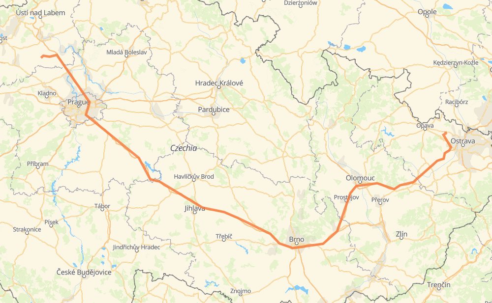
Distance between Popels and Beneschau

The distance from Popels to Beneschau is 440 kilometers by road including 382 kilometers on motorways. Road takes approximately 4 hours and 19 minutes and goes through Prague, Iglau, Brünn, Olmütz and Ostrau.

There are tolls on the route.
Click here to load the interactive map
Compare this route in other services:
City
Town
Village
Hamlet
Motorway
Primary
Secondary
Unclassified
Point Distance Time Fuel
Popels 0 km 0:00 00 min 0.0 L
246 D8 41 km, 26 min
Odolenswasser 41 km 0:26 26 min 3.1 L
D8 21 km, 14 min
Prague 62 km 0:41 41 min 3.9 L
601 D1 20 km, 14 min
Ritschan 82 km 0:55 55 min 6.4 L
D1 78 km, 42 min
Humpoletz 160 km 1:38 1 h 38 min 12.4 L
D1 21 km, 11 min
Iglau 181 km 1:49 1 h 49 min 14.1 L
D1 84 km, 46 min
Brünn 264 km 2:35 2 h 35 min 20.5 L
D1 D46 75 km, 41 min
Olmütz 339 km 3:17 3 h 17 min 26.6 L
D35 D1 86 km, 48 min
Ostrau 425 km 4:05 4 h 05 min 33.6 L
11 46610 15 km, 13 min
Beneschau 440 km 4:19 4 h 19 min 34.9 L
City
Town
Village
Hamlet
Motorway
Primary
Secondary
Unclassified
Point Distance Time Fuel
Popels 0 km 0:00 00 min 0.0 L
246 5 km, 03 min
Žabovřesky nad Ohří 5 km 0:03 03 min 0.3 L
246 3 km, 02 min
Budyně nad Ohří 8 km 0:05 05 min 0.5 L
246 4 km, 03 min
Nížebohy 12 km 0:09 09 min 0.8 L
246 D8 14 km, 08 min
Ledčice 26 km 0:17 17 min 1.8 L
D8 4 km, 01 min
Nová Ves 29 km 0:19 19 min 2.3 L
D8 5 km, 02 min
Všestudy 34 km 0:22 22 min 2.5 L
D8 3 km, 01 min
Úžice 37 km 0:23 23 min 2.9 L
D8 4 km, 02 min
Odolenswasser 41 km 0:26 26 min 3.1 L
D8 4 km, 02 min
Klíčany 45 km 0:28 28 min 3.5 L
D8 3 km, 01 min
Zdiby 48 km 0:29 29 min 3.8 L
D8 14 km, 11 min
Prague 62 km 0:40 40 min 3.9 L
601 D1 15 km, 11 min
Pruhonitz 77 km 0:52 52 min 6.0 L
D1 5 km, 02 min
Ritschan 82 km 0:55 55 min 6.4 L
D1 6 km, 02 min
Kunice 87 km 0:58 58 min 6.8 L
D1 3 km, 01 min
Mirošovice 91 km 1:00 1 h 00 min 7.2 L
D1 2 km, 00 min
Hrusice 92 km 1:00 1 h 00 min 7.3 L
D1 3 km, 01 min
Poddubí 96 km 1:02 1 h 02 min 7.5 L
D1 3 km, 01 min
Hvězdonice 98 km 1:04 1 h 04 min 7.8 L
D1 8 km, 04 min
Bělčice 106 km 1:08 1 h 08 min 7.9 L
D1 11 km, 05 min
Psáře 117 km 1:14 1 h 14 min 9.2 L
D1 4 km, 02 min
Střechov nad Sázavou 121 km 1:16 1 h 16 min 9.5 L
D1 3 km, 01 min
Černýš 124 km 1:18 1 h 18 min 9.9 L
D1 2 km, 01 min
Soutice 126 km 1:19 1 h 19 min 9.9 L
D1 7 km, 03 min
Bernartice 133 km 1:22 1 h 22 min 10.6 L
D1 3 km, 01 min
Loket 136 km 1:24 1 h 24 min 10.7 L
D1 7 km, 03 min
Dunice 143 km 1:28 1 h 28 min 11.3 L
D1 6 km, 03 min
Vojslavice 149 km 1:31 1 h 31 min 11.7 L
D1 5 km, 02 min
Speřice 154 km 1:34 1 h 34 min 12.2 L
D1 6 km, 03 min
Humpoletz 160 km 1:37 1 h 37 min 12.4 L
D1 6 km, 03 min
Pavlov u Herálce 166 km 1:41 1 h 41 min 13.2 L
D1 4 km, 02 min
Skorkov 171 km 1:43 1 h 43 min 13.5 L
D1 10 km, 05 min
Iglau 181 km 1:48 1 h 48 min 14.1 L
D1 5 km, 02 min
Měšín 186 km 1:51 1 h 51 min 14.8 L
D1 4 km, 02 min
Kozlov 190 km 1:53 1 h 53 min 15.1 L
D1 5 km, 02 min
Věžnice 195 km 1:56 1 h 56 min 15.4 L
D1 5 km, 02 min
Meziříčko 200 km 1:59 1 h 59 min 15.8 L
D1 3 km, 01 min
Měřín 203 km 2:01 2 h 01 min 16.2 L
D1 4 km, 02 min
Stránecká Zhoř 207 km 2:03 2 h 03 min 16.5 L
D1 2 km, 01 min
Lavičky 210 km 2:04 2 h 04 min 16.7 L
D1 5 km, 03 min
Groß Meseritsch 215 km 2:07 2 h 07 min 16.9 L
D1 6 km, 03 min
Jabloňov 221 km 2:11 2 h 11 min 17.5 L
D1 14 km, 07 min
Groß Bittesch 235 km 2:19 2 h 19 min 17.8 L
D1 14 km, 07 min
Schwarzkirchen 250 km 2:26 2 h 26 min 19.8 L
D1 5 km, 02 min
Popuwek 255 km 2:29 2 h 29 min 20.3 L
D1 10 km, 05 min
Brünn 264 km 2:35 2 h 35 min 20.5 L
D1 9 km, 04 min
Schlapanitz 273 km 2:39 2 h 39 min 21.8 L
D1 6 km, 03 min
Holubice 279 km 2:43 2 h 43 min 22.1 L
D1 6 km, 03 min
Raußnitz 286 km 2:46 2 h 46 min 22.6 L
D1 12 km, 06 min
Wischau 297 km 2:53 2 h 53 min 23.3 L
D1 9 km, 04 min
Drysice 306 km 2:58 2 h 58 min 24.3 L
D46 5 km, 02 min
Brodek u Prostějova 311 km 3:01 3 h 01 min 24.8 L
D46 4 km, 02 min
Kelčice 315 km 3:03 3 h 03 min 25.0 L
D46 6 km, 03 min
Proßnitz in Mähren 322 km 3:06 3 h 06 min 25.5 L
D46 5 km, 03 min
Držowitz 327 km 3:09 3 h 09 min 26.0 L
D46 4 km, 02 min
Olšany u Prostějova 331 km 3:11 3 h 11 min 26.3 L
D46 8 km, 04 min
Olmütz 339 km 3:16 3 h 16 min 26.6 L
D35 11 km, 06 min
Svésedlice 350 km 3:22 3 h 22 min 27.8 L
D35 4 km, 01 min
Kocourovec 354 km 3:24 3 h 24 min 28.3 L
D35 2 km, 01 min
Daskabát 356 km 3:25 3 h 25 min 28.4 L
D35 4 km, 02 min
Velký Újezd 360 km 3:28 3 h 28 min 28.6 L
D35 2 km, 01 min
Staměřice 362 km 3:29 3 h 29 min 29.0 L
D35 2 km, 00 min
Dolní Újezd 364 km 3:30 3 h 30 min 29.0 L
D35 7 km, 03 min
Leipnik 370 km 3:33 3 h 33 min 29.2 L
D1 8 km, 04 min
Mährisch Weißkirchen 379 km 3:38 3 h 38 min 30.1 L
D1 9 km, 05 min
Heinzendorf 388 km 3:43 3 h 43 min 31.0 L
D1 4 km, 02 min
Mankovice 392 km 3:45 3 h 45 min 31.3 L
D1 10 km, 05 min
Kujavy 402 km 3:50 3 h 50 min 32.1 L
D1 2 km, 01 min
Stauding 405 km 3:52 3 h 52 min 32.3 L
D1 8 km, 04 min
Bravantice 413 km 3:56 3 h 56 min 33.0 L
D1 3 km, 01 min
Janovice 416 km 3:58 3 h 58 min 33.2 L
D1 3 km, 01 min
Königsberg in Schlesien 419 km 3:59 3 h 59 min 33.3 L
D1 6 km, 04 min
Ostrau 425 km 4:04 4 h 04 min 33.6 L
11 10 km, 07 min
Freiheitsau 435 km 4:12 4 h 12 min 34.6 L
46610 5 km, 05 min
Beneschau 440 km 4:18 4 h 18 min 34.9 L

Frequently Asked Questions

How much does it cost to drive from Popels to Beneschau?

Fuel cost: 68 CAD

This fuel cost is calculated as: (Route length 440 km / 100 km) * (Fuel consumption 8 L/100 km) * (Fuel price 1.93 CAD / L)

You can adjust fuel consumption and fuel price here.

How long is a car ride from Popels to Beneschau?

Driving time: 4 h 19 min

This time is calculated for driving at the maximum permitted speed, taking into account traffic rules restrictions.

  • 361 km with a maximum speed 110 km/h = 3 h 16 min
  • 11 km with a maximum speed 100 km/h = 6 min
  • 22 km with a maximum speed 90 km/h = 14 min
  • 32 km with a maximum speed 80 km/h = 23 min
  • 14 km with a maximum speed 50 km/h = 16 min

The calculated driving time does not take into account intermediate stops and traffic jams.

How far is Popels to Beneschau by land?

The distance between Popels and Beneschau is 440 km by road including 382 km on motorways.

Precise satellite coordinates of highways were used for this calculation. The start and finish points are the centers of Popels and Beneschau respectively.

How far is Popels to Beneschau by plane?

The shortest distance (air line, as the crow flies) between Popels and Beneschau is 294 km.

This distance is calculated using the Haversine formula as a great-circle distance between two points on the surface of a sphere. The start and finish points are the centers of Popels and Beneschau respectively. Actual distance between airports may be different.

How many hours is Popels from Beneschau by plane?

Boeing 737 airliner needs 22 min to cover the distance of 294 km at a cruising speed of 800 km/h.

Small plane "Cessna 172" needs 1 h 20 min to flight this distance at average speed of 220 km/h.

This time is approximate and do not take into account takeoff and landing times, airport location and other real world factors.

How long is a helicopter ride from Popels to Beneschau?

Fast helicopter "Eurocopter AS350" or "Hughes OH-6 Cayuse" need 1 h 13 min to cover the distance of 294 km at a cruising speed of 240 km/h.

Popular "Robinson R44" needs 1 h 24 min to flight this distance at average speed of 210 km/h.

This time is approximate and do not take into account takeoff and landing times, aerodrome location and other real world factors.

What city is halfway between Popels and Beneschau?

The halfway point between Popels and Beneschau is Jabloňov. It is located about 1 km from the exact midpoint by road.

The distance from Jabloňov to Popels is 221 km and driving will take about 2 h 11 min. The road between Jabloňov and Beneschau has length 219 km and will take approximately 2 h 8 min.

The other cities located close to halfway point:

  • Groß Meseritsch is in 215 km from Popels and 225 km from Beneschau
  • Lavičky is in 210 km from Popels and 231 km from Beneschau
  • Stránecká Zhoř is in 207 km from Popels and 233 km from Beneschau

Where is Popels in relation to Beneschau?

Popels is located 294 km west of Beneschau.

Popels has geographic coordinates: latitude 50.39695, longitude 14.04304.

Beneschau has geographic coordinates: latitude 49.92101, longitude 18.10835.

Which highway goes from Popels to Beneschau?

The route from Popels to Beneschau follows D1.

Other minor sections pass along the road:

  • D46: 39 km
  • D8: 31 km
  • D35: 28 km
  • 246: 13 km
  • 11: 9 km
  • 601: 9 km
  • MO: 4 km
  • 4676: 4 km
  • 608: 3 km
  • 8: 3 km
  • 46610: 3 km
  • 647: 2 km
  • 237: 1 km
  • 4673: 1 km
The distance between Popels and Beneschau is ranked 17,416th in the ranking popularity.
Have any questions? Contact us!