Distance between Peterborough ON and Toronto OH
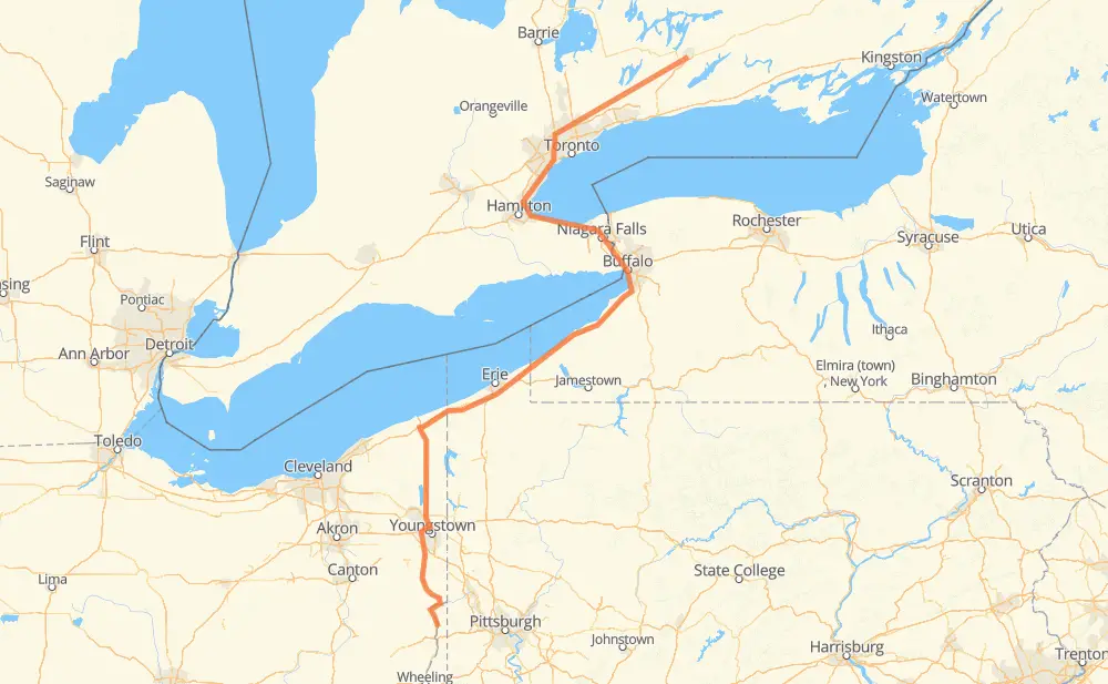
The distance from Peterborough to Toronto is 674 kilometers by road including 644 kilometers on motorways. Road takes approximately 6 hours and 45 minutes and goes through Oshawa, Markham, Richmond Hill, Vaughan, Toronto, Mississauga and Burlington.
| Shortest distance by air | 464 km ✈️ |
| Car route length | 674 km 🚗 |
| Driving time | 6 h 45 min |
| Fuel amount | 54 L |
| Fuel cost | 104.1 CAD |
| Point | Distance | Time | Fuel | |
| Peterborough | 0 km | 00 min | 0.0 L | |
|
7 115 65 km, 41 min
|
||||
| Oshawa | 65 km | 41 min | 4.8 L | |
|
407 Toll 36 km, 21 min
|
||||
| Markham | 102 km | 1 h 03 min | 7.3 L | |
|
407 ETR 17 km, 10 min
|
||||
| Vaughan | 118 km | 1 h 13 min | 9.0 L | |
|
407 ETR 17 km, 10 min
|
||||
| Toronto | 136 km | 1 h 24 min | 10.0 L | |
|
401 18 km, 10 min
|
||||
| Mississauga | 153 km | 1 h 34 min | 11.7 L | |
|
QEW 31 km, 18 min
|
||||
| Burlington | 184 km | 1 h 53 min | 14.2 L | |
|
QEW 55 km, 31 min
|
||||
| St. Catharines | 238 km | 2 h 24 min | 18.6 L | |
|
QEW 15 km, 08 min
|
||||
| Niagara Falls | 253 km | 2 h 33 min | 19.9 L | |
|
QEW 36 km, 22 min
|
||||
| Buffalo | 289 km | 2 h 56 min | 22.8 L | |
|
NY 5 I 90 385 km, 3 h 48 min
|
||||
| Toronto | 674 km | 6 h 44 min | 53.9 L | |
Frequently Asked Questions
How much does it cost to drive from Peterborough to Toronto?
Fuel cost: 104.1 CAD
This fuel cost is calculated as: (Route length 674 km / 100 km) * (Fuel consumption 8 L/100 km) * (Fuel price 1.93 CAD / L)
You can adjust fuel consumption and fuel price here.
How long is a car ride from Peterborough to Toronto?
Driving time: 6 h 45 min
This time is calculated for driving at the maximum permitted speed, taking into account traffic rules restrictions.
- 138 km with a maximum speed 110 km/h = 1 h 15 min
- 175 km with a maximum speed 105 km/h = 1 h 40 min
- 280 km with a maximum speed 100 km/h = 2 h 47 min
- 11 km with a maximum speed 90 km/h = 7 min
- 22 km with a maximum speed 89 km/h = 14 min
- 9 km with a maximum speed 80 km/h = 7 min
- 35 km with a maximum speed 80 km/h = 25 min
- 4 km with a maximum speed 50 km/h = 4 min
The calculated driving time does not take into account intermediate stops and traffic jams.
How far is Peterborough to Toronto by land?
The distance between Peterborough and Toronto is 674 km by road including 644 km on motorways.
Precise satellite coordinates of highways were used for this calculation. The start and finish points are the centers of Peterborough and Toronto respectively.
How far is Peterborough to Toronto by plane?
The shortest distance (air line, as the crow flies) between Peterborough and Toronto is 464 km.
This distance is calculated using the Haversine formula as a great-circle distance between two points on the surface of a sphere. The start and finish points are the centers of Peterborough and Toronto respectively. Actual distance between airports may be different.
How many hours is Peterborough from Toronto by plane?
Boeing 737 airliner needs 34 min to cover the distance of 464 km at a cruising speed of 800 km/h.
Small plane "Cessna 172" needs 2 h 6 min to flight this distance at average speed of 220 km/h.
This time is approximate and do not take into account takeoff and landing times, airport location and other real world factors.
How long is a helicopter ride from Peterborough to Toronto?
Fast helicopter "Eurocopter AS350" or "Hughes OH-6 Cayuse" need 1 h 56 min to cover the distance of 464 km at a cruising speed of 240 km/h.
Popular "Robinson R44" needs 2 h 12 min to flight this distance at average speed of 210 km/h.
This time is approximate and do not take into account takeoff and landing times, aerodrome location and other real world factors.
What city is halfway between Peterborough and Toronto?
The halfway point between Peterborough and Toronto is Sheridan. It is located about 14 km from the exact midpoint by road.
The distance from Sheridan to Peterborough is 351 km and driving will take about 3 h 33 min. The road between Sheridan and Toronto has length 324 km and will take approximately 3 h 11 min.
The other cities located close to halfway point:
Where is Peterborough in relation to Toronto?
Peterborough is located 464 km north-east of Toronto.
Peterborough has geographic coordinates: latitude 44.28872, longitude -78.32874.
Toronto has geographic coordinates: latitude 40.46423, longitude -80.60091.
Which highway goes from Peterborough to Toronto?
The route from Peterborough to Toronto follows I 90, SR 11, QEW.
Other minor sections pass along the road:
- 407 Toll: 43 km
- 407 ETR: 39 km
- 115: 36 km
- SR 7: 32 km
- 403: 21 km
- US 30: 14 km
- NY 5: 12 km
- SR 39: 7 km
- I 80: 6 km
- 401: 6 km
- 427: 6 km
- 7: 6 km
- 400: 5 km
- NY 75: 5 km
- 35: 4 km
- I 190: 2 km