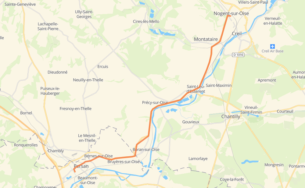
Distance between Persan and Nogent-sur-Oise
The distance from Persan to Nogent-sur-Oise is 24 kilometers by road. Road takes approximately 22 minutes and goes through Montataire, Bernes-sur-Oise, Bruyères-sur-Oise, Boran-sur-Oise, Précy-sur-Oise and Villers-sous-Saint-Leu.
| Shortest distance by air | 20 km ✈️ |
| Car route length | 24 km 🚗 |
| Driving time | 22 min |
| Fuel amount | 2 L |
| Fuel cost | 3.8 CAD |
| Point | Distance | Time | Fuel | |
| Persan | 0 km | 00 min | 0.0 L | |
|
D 4z 3 km, 03 min
|
||||
| Bernes-sur-Oise | 3 km | 03 min | 0.2 L | |
|
D 4z 2 km, 02 min
|
||||
| Bruyères-sur-Oise | 5 km | 05 min | 0.2 L | |
|
D 924 D 603 3 km, 02 min
|
||||
| Boran-sur-Oise | 7 km | 07 min | 0.5 L | |
|
D 603 5 km, 04 min
|
||||
| Précy-sur-Oise | 13 km | 11 min | 1.0 L | |
|
D 92 2 km, 01 min
|
||||
| Villers-sous-Saint-Leu | 14 km | 13 min | 1.1 L | |
|
D 92 6 km, 06 min
|
||||
| Montataire | 21 km | 19 min | 1.5 L | |
|
D 200 4 km, 02 min
|
||||
| Nogent-sur-Oise | 24 km | 22 min | 1.8 L | |
Frequently Asked Questions
How much does it cost to drive from Persan to Nogent-sur-Oise?
Fuel cost: 3.8 CAD
This fuel cost is calculated as: (Route length 24 km / 100 km) * (Fuel consumption 8 L/100 km) * (Fuel price 1.96 CAD / L)
You can adjust fuel consumption and fuel price here.
How long is a car ride from Persan to Nogent-sur-Oise?
Driving time: 22 min
This time is calculated for driving at the maximum permitted speed, taking into account traffic rules restrictions.
- 3 km with a maximum speed 90 km/h = 2 min
- 10 km with a maximum speed 80 km/h = 7 min
- 10 km with a maximum speed 50 km/h = 11 min
The calculated driving time does not take into account intermediate stops and traffic jams.
How far is Persan to Nogent-sur-Oise by land?
The distance between Persan and Nogent-sur-Oise is 24 km by road.
Precise satellite coordinates of highways were used for this calculation. The start and finish points are the centers of Persan and Nogent-sur-Oise respectively.
What city is halfway between Persan and Nogent-sur-Oise?
The halfway point between Persan and Nogent-sur-Oise is Précy-sur-Oise.
The distance from Précy-sur-Oise to Persan is 13 km and driving will take about 11 min. The road between Précy-sur-Oise and Nogent-sur-Oise has length 12 km and will take approximately 11 min.
The other cities located close to halfway point:
Where is Persan in relation to Nogent-sur-Oise?
Persan is located 20 km south-west of Nogent-sur-Oise.
Persan has geographic coordinates: latitude 49.14859, longitude 2.26751.
Nogent-sur-Oise has geographic coordinates: latitude 49.2775, longitude 2.46638.
Which highway goes from Persan to Nogent-sur-Oise?
The route from Persan to Nogent-sur-Oise follows D 92.
Other minor sections pass along the road:
- D 603: 5 km
- D 200: 4 km
- D 4z: 3 km
- D 924: 2 km
- D 924z: 1 km