Distance between Passo Fundo and Ponta Grossa
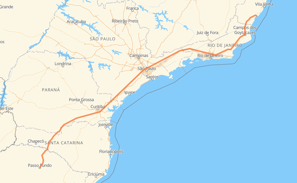
The distance from Passo Fundo to Ponta Grossa is 1,846 kilometers by road including 931 kilometers on motorways. Road takes approximately 21 hours and 21 minutes and goes through Piraquara, Taboão da Serra, Jacareí, Guaratinguetá and Magé.
| Shortest distance by air | 1,447 km ✈️ |
| Car route length | 1,846 km 🚗 |
| Driving time | 21 h 21 min |
| Fuel amount | 147.7 L |
| Fuel cost | 289.5 CAD |
| Point | Distance | Time | Fuel | |
| Passo Fundo | 0 km | 00 min | 0.0 L | |
|
2 km, 02 min
|
||||
| VILA POPULAR | 2 km | 02 min | 0.1 L | |
|
ERS-135 127 km, 1 h 34 min
|
||||
| Linha Água Verde | 128 km | 1 h 36 min | 9.7 L | |
|
BR-153 16 km, 11 min
|
||||
| Posto Cem | 144 km | 1 h 48 min | 11.1 L | |
|
BR-153 BR-476 423 km, 4 h 45 min
|
||||
| Piraquara | 568 km | 6 h 33 min | 44.8 L | |
|
BR-116 381 km, 4 h 05 min
|
||||
| Taboão da Serra | 949 km | 10 h 38 min | 75.9 L | |
|
SP-230 SP-070 114 km, 1 h 10 min
|
||||
| Jacareí | 1,063 km | 11 h 49 min | 84.8 L | |
|
SP-070 SP-060 103 km, 1 h 00 min
|
||||
| Guaratinguetá | 1,166 km | 12 h 49 min | 93.1 L | |
|
SP-060 BR-116 271 km, 2 h 58 min
|
||||
| Magé | 1,437 km | 15 h 48 min | 114.5 L | |
|
BR-493 BR-101 428 km, 5 h 33 min
|
||||
| Ponta Grossa | 1,865 km | 21 h 21 min | 149.2 L | |
Frequently Asked Questions
How much does it cost to drive from Passo Fundo to Ponta Grossa?
Fuel cost: 289.5 CAD
This fuel cost is calculated as: (Route length 1,846 km / 100 km) * (Fuel consumption 8 L/100 km) * (Fuel price 1.96 CAD / L)
You can adjust fuel consumption and fuel price here.
How long is a car ride from Passo Fundo to Ponta Grossa?
Driving time: 21 h 21 min
This time is calculated for driving at the maximum permitted speed, taking into account traffic rules restrictions.
- 518 km with a maximum speed 110 km/h = 4 h 42 min
- 191 km with a maximum speed 100 km/h = 1 h 54 min
- 585 km with a maximum speed 90 km/h = 6 h 30 min
- 350 km with a maximum speed 80 km/h = 4 h 22 min
- 32 km with a maximum speed 70 km/h = 27 min
- 155 km with a maximum speed 60 km/h = 2 h 34 min
- 7 km with a maximum speed 50 km/h = 8 min
- 27 km with a maximum speed 40 km/h = 40 min
- 1 km with a maximum speed 30 km/h = 1 min
The calculated driving time does not take into account intermediate stops and traffic jams.
How far is Passo Fundo to Ponta Grossa by land?
The distance between Passo Fundo and Ponta Grossa is 1,846 km by road including 931 km on motorways.
Precise satellite coordinates of highways were used for this calculation. The start and finish points are the centers of Passo Fundo and Ponta Grossa respectively.
How far is Passo Fundo to Ponta Grossa by plane?
The shortest distance (air line, as the crow flies) between Passo Fundo and Ponta Grossa is 1,447 km.
This distance is calculated using the Haversine formula as a great-circle distance between two points on the surface of a sphere. The start and finish points are the centers of Passo Fundo and Ponta Grossa respectively. Actual distance between airports may be different.
How many hours is Passo Fundo from Ponta Grossa by plane?
Boeing 737 airliner needs 1 h 48 min to cover the distance of 1,447 km at a cruising speed of 800 km/h.
Small plane "Cessna 172" needs 6 h 34 min to flight this distance at average speed of 220 km/h.
This time is approximate and do not take into account takeoff and landing times, airport location and other real world factors.
How long is a helicopter ride from Passo Fundo to Ponta Grossa?
Fast helicopter "Eurocopter AS350" or "Hughes OH-6 Cayuse" need 6 h 1 min to cover the distance of 1,447 km at a cruising speed of 240 km/h.
Popular "Robinson R44" needs 6 h 53 min to flight this distance at average speed of 210 km/h.
This time is approximate and do not take into account takeoff and landing times, aerodrome location and other real world factors.
What city is halfway between Passo Fundo and Ponta Grossa?
The halfway point between Passo Fundo and Ponta Grossa is Bairro do Soturno. It is located about 11 km from the exact midpoint by road.
The distance from Bairro do Soturno to Passo Fundo is 912 km and driving will take about 10 h 17 min. The road between Bairro do Soturno and Ponta Grossa has length 934 km and will take approximately 11 h 4 min.
The other cities located close to halfway point:
Where is Passo Fundo in relation to Ponta Grossa?
Passo Fundo is located 1,447 km south-west of Ponta Grossa.
Passo Fundo has geographic coordinates: latitude -28.26161, longitude -52.4089.
Ponta Grossa has geographic coordinates: latitude -20.81289, longitude -40.66823.
Which highway goes from Passo Fundo to Ponta Grossa?
The route from Passo Fundo to Ponta Grossa follows BR-116, BR-101, SP-230, BR-153, BR-476, SP-060, SP-070.
Other minor sections pass along the road:
- ERS-135: 72 km
- BR-493: 71 km
- BR-478: 48 km
- SP-015: 22 km
- BR-277: 22 km
- RJ-109: 19 km
- BR-459: 14 km
- SP-021: 13 km
- BR-383: 11 km
- ES-375: 9 km
- ES-060: 8 km
- BR-050: 7 km
- BR-374: 4 km
- SP-280: 4 km
- SPI 117/070: 3 km
- KM-272: 3 km
- SPM-280 E: 2 km
- SPI-016/021: 2 km