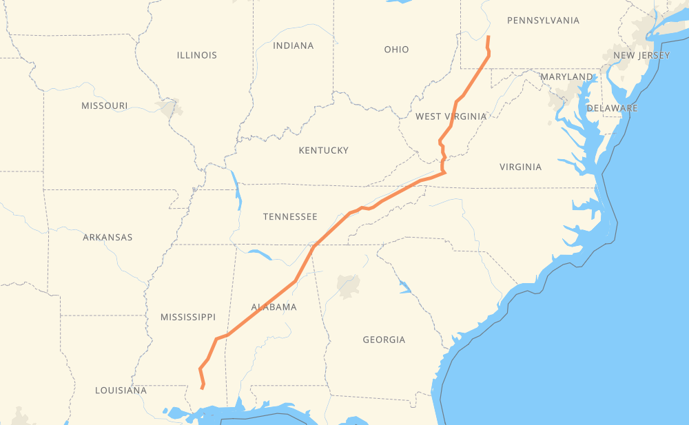
The distance from Oklahoma to Texas is 1,654 kilometers by road including 1,464 kilometers on motorways. Road takes approximately 16 hours and 4 minutes and goes through Kingsport, Knoxville, Chattanooga, Birmingham, Tuscaloosa and Hattiesburg.
How much does it cost to drive from Oklahoma to Texas?
Fuel cost:
259.4 CAD
This fuel cost is calculated as: (Route length 1,654 km / 100 km) * (Fuel consumption 8 L/100 km) * (Fuel price 1.96 CAD / L)
You can adjust fuel consumption and fuel price here.
How long is a car ride from Oklahoma to Texas?
Driving time:
16 h 4 min
This time is calculated for driving at the maximum permitted speed, taking into account traffic rules restrictions.
1,067 km with a maximum speed 110 km/h = 9 h 42 min
206 km with a maximum speed 105 km/h = 1 h 58 min
73 km with a maximum speed 100 km/h = 43 min
33 km with a maximum speed 97 km/h = 20 min
107 km with a maximum speed 90 km/h = 1 h 11 min
47 km with a maximum speed 89 km/h = 31 min
14 km with a maximum speed 80 km/h = 10 min
74 km with a maximum speed 80 km/h = 55 min
23 km with a maximum speed 72 km/h = 18 min
1 km with a maximum speed 64 km/h = 1 min
2 km with a maximum speed 56 km/h = 2 min
6 km with a maximum speed 50 km/h = 7 min
The calculated driving time does not take into account intermediate stops and traffic jams.
How far is Oklahoma to Texas by land?
The distance between Oklahoma and Texas is 1,654 km by road including 1,464 km on motorways.
Precise satellite coordinates of highways were used for this calculation. The start and finish points are the centers of Oklahoma and Texas respectively.
How far is Oklahoma to Texas by plane?
The shortest distance (air line, as the crow flies) between Oklahoma and Texas is 1,387 km.
This distance is calculated using the Haversine formula as a great-circle distance between two points on the surface of a sphere. The start and finish points are the centers of Oklahoma and Texas respectively. Actual distance between airports may be different.
How many hours is Oklahoma from Texas by plane?
Boeing 737 airliner needs 1 h 44 min to cover the distance of 1,387 km at a cruising speed of 800 km/h.
Small plane "Cessna 172" needs 6 h 18 min to flight this distance at average speed of 220 km/h.
This time is approximate and do not take into account takeoff and landing times, airport location and other real world factors.
How long is a helicopter ride from Oklahoma to Texas?
Fast helicopter "Eurocopter AS350" or "Hughes OH-6 Cayuse" need 5 h 46 min to cover the distance of 1,387 km at a cruising speed of 240 km/h.
Popular "Robinson R44" needs 6 h 36 min to flight this distance at average speed of 210 km/h.
This time is approximate and do not take into account takeoff and landing times, aerodrome location and other real world factors.
What city is halfway between Oklahoma and Texas?
The halfway point between Oklahoma and Texas is Green Valley. It is located about 11 km from the exact midpoint by road.
The distance from Green Valley to Oklahoma is 817 km and driving will take about 7 h 55 min. The road between Green Valley and Texas has length 838 km and will take approximately 8 h 8 min.
The other cities located close to halfway point:
Oak Grove is in 847 km from Oklahoma and 807 km from Texas
Knoxville is in 804 km from Oklahoma and 850 km from Texas
4th and Gill is in 802 km from Oklahoma and 852 km from Texas
Where is Oklahoma in relation to Texas?
Oklahoma is located 1,387 km north-east of Texas.
Oklahoma has geographic coordinates: latitude 40.58144, longitude -79.57402.
Texas has geographic coordinates: latitude 30.88602, longitude -89.272.
Which highway goes from Oklahoma to Texas?
The route from Oklahoma to Texas follows I 59, I 20, I 81, I 75, I 79, US 19, I 77.