Distance between Oakdale MN and Bladworth SK
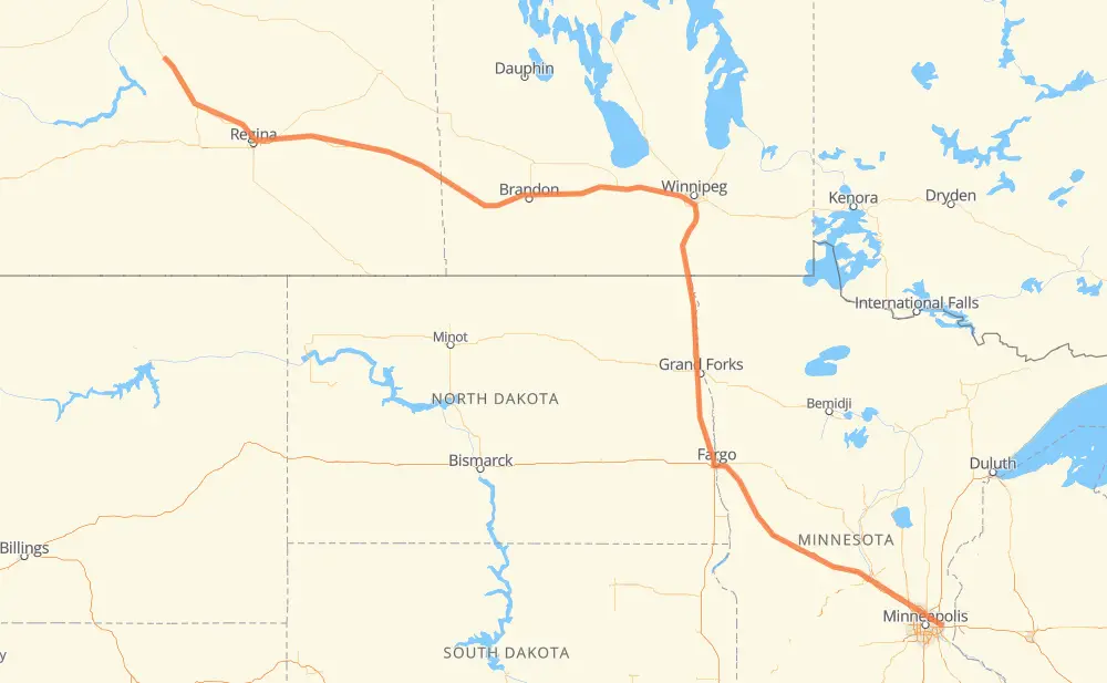
The distance from Oakdale to Bladworth is 1,482 kilometers by road including 671 kilometers on motorways. Road takes approximately 16 hours and 1 minute and goes through Fargo, Grand Forks, Winnipeg, Portage la Prairie, Brandon and Regina.
| Shortest distance by air | 1,206 km ✈️ |
| Car route length | 1,482 km 🚗 |
| Driving time | 16 h 1 min |
| Fuel amount | 118.5 L |
| Fuel cost | 232.3 CAD |
| Point | Distance | Time | Fuel | |
| Oakdale | 0 km | 00 min | 0.0 L | |
|
I 694 13 km, 10 min
|
||||
| White Bear Lake | 13 km | 10 min | 1.0 L | |
|
I 694 5 km, 03 min
|
||||
| Vadnais Heights | 18 km | 13 min | 1.0 L | |
|
I 694 I 94 389 km, 3 h 36 min
|
||||
| Fargo | 406 km | 3 h 49 min | 31.7 L | |
|
I 29 102 km, 1 h 10 min
|
||||
| Grand Forks | 508 km | 4 h 59 min | 38.7 L | |
|
I 29 243 km, 2 h 47 min
|
||||
| Winnipeg | 751 km | 7 h 46 min | 59.1 L | |
|
PTH 100 PTH 1 88 km, 59 min
|
||||
| Portage la Prairie | 839 km | 8 h 46 min | 66.5 L | |
|
PTH 1 123 km, 1 h 22 min
|
||||
| Brandon | 962 km | 10 h 08 min | 76.7 L | |
|
PTH 1 1 362 km, 4 h 07 min
|
||||
| Regina | 1,323 km | 14 h 15 min | 105.5 L | |
|
46 11 158 km, 1 h 45 min
|
||||
| Bladworth | 1,482 km | 16 h 01 min | 112.9 L | |
Frequently Asked Questions
How much does it cost to drive from Oakdale to Bladworth?
Fuel cost: 232.3 CAD
This fuel cost is calculated as: (Route length 1,482 km / 100 km) * (Fuel consumption 8 L/100 km) * (Fuel price 1.96 CAD / L)
You can adjust fuel consumption and fuel price here.
How long is a car ride from Oakdale to Bladworth?
Driving time: 16 h 1 min
This time is calculated for driving at the maximum permitted speed, taking into account traffic rules restrictions.
- 368 km with a maximum speed 110 km/h = 3 h 20 min
- 88 km with a maximum speed 100 km/h = 53 min
- 43 km with a maximum speed 97 km/h = 26 min
- 700 km with a maximum speed 90 km/h = 7 h 46 min
- 17 km with a maximum speed 89 km/h = 11 min
- 254 km with a maximum speed 80 km/h = 3 h 10 min
- 1 km with a maximum speed 70 km/h = 1 min
- 2 km with a maximum speed 60 km/h = 2 min
- 7 km with a maximum speed 50 km/h = 8 min
The calculated driving time does not take into account intermediate stops and traffic jams.
How far is Oakdale to Bladworth by land?
The distance between Oakdale and Bladworth is 1,482 km by road including 671 km on motorways.
Precise satellite coordinates of highways were used for this calculation. The start and finish points are the centers of Oakdale and Bladworth respectively.
How far is Oakdale to Bladworth by plane?
The shortest distance (air line, as the crow flies) between Oakdale and Bladworth is 1,206 km.
This distance is calculated using the Haversine formula as a great-circle distance between two points on the surface of a sphere. The start and finish points are the centers of Oakdale and Bladworth respectively. Actual distance between airports may be different.
How many hours is Oakdale from Bladworth by plane?
Boeing 737 airliner needs 1 h 30 min to cover the distance of 1,206 km at a cruising speed of 800 km/h.
Small plane "Cessna 172" needs 5 h 28 min to flight this distance at average speed of 220 km/h.
This time is approximate and do not take into account takeoff and landing times, airport location and other real world factors.
How long is a helicopter ride from Oakdale to Bladworth?
Fast helicopter "Eurocopter AS350" or "Hughes OH-6 Cayuse" need 5 h 1 min to cover the distance of 1,206 km at a cruising speed of 240 km/h.
Popular "Robinson R44" needs 5 h 44 min to flight this distance at average speed of 210 km/h.
This time is approximate and do not take into account takeoff and landing times, aerodrome location and other real world factors.
What city is halfway between Oakdale and Bladworth?
The halfway point between Oakdale and Bladworth is St. Adolphe. It is located about 7 km from the exact midpoint by road.
The distance from St. Adolphe to Oakdale is 734 km and driving will take about 7 h 34 min. The road between St. Adolphe and Bladworth has length 748 km and will take approximately 8 h 27 min.
The other cities located close to halfway point:
Where is Oakdale in relation to Bladworth?
Oakdale is located 1,206 km south-east of Bladworth.
Oakdale has geographic coordinates: latitude 44.96302, longitude -92.96494.
Bladworth has geographic coordinates: latitude 51.36667, longitude -106.13333.
Which highway goes from Oakdale to Bladworth?
The route from Oakdale to Bladworth follows I 94, PTH 1, I 29, 1, US 81, 11.
Other minor sections pass along the road:
- PTH 75: 94 km
- I 694: 41 km
- 46: 22 km
- PTH 100: 19 km
- US 59: 17 km
- 2: 11 km
- 11A: 9 km
- 47: 8 km
- PTH 83: 7 km
- PR 254: 5 km
- MN 210: 5 km
- US 10: 5 km
- US 52: 4 km
- PR 241: 4 km
- PR 250: 4 km
- 6: 3 km
- Route 42: 3 km
- PR 427: 2 km
- PR 334: 2 km
- PTH 10: 2 km
- 8: 1 km