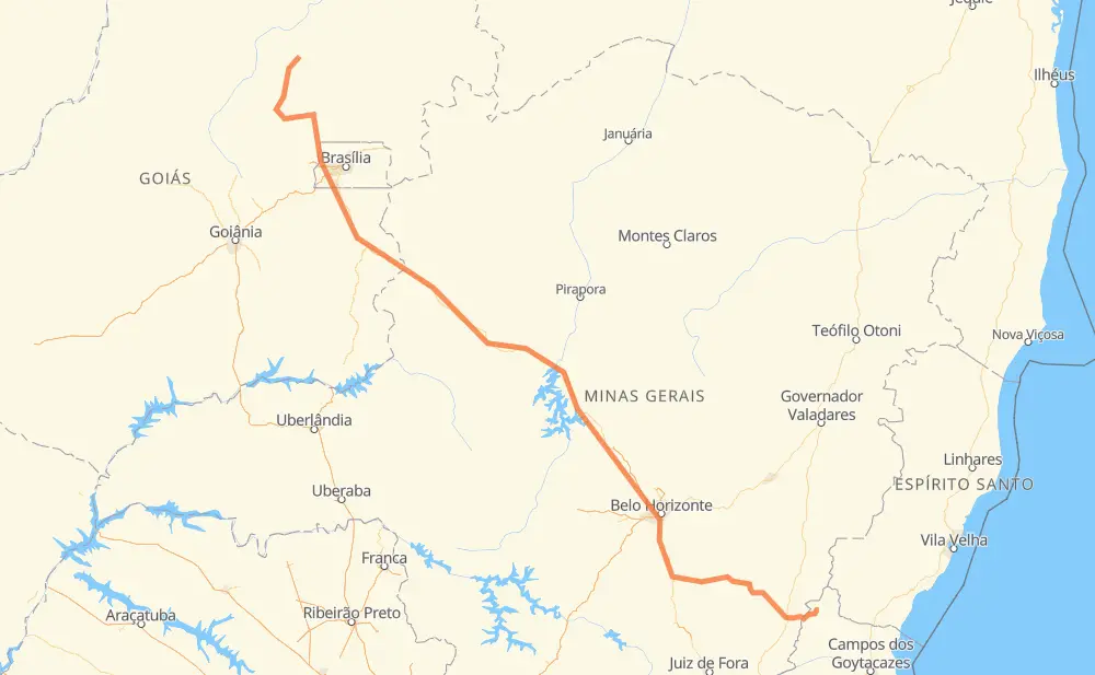
Distance between Niquelândia and Natividade
The distance from Niquelândia to Natividade is 1,331 kilometers by road including 143 kilometers on motorways. Road takes approximately 15 hours and 41 minutes and goes through Ceilândia, Recanto das Emas, Valparaíso de Goiás, Ribeirão das Neves, Conselheiro Lafaiete and Muriaé.
| Shortest distance by air | 1,002 km ✈️ |
| Car route length | 1,331 km 🚗 |
| Driving time | 15 h 41 min |
| Fuel amount | 106.5 L |
| Fuel cost | 210.8 CAD |
| Point | Distance | Time | Fuel | |
| -14.46487, -48.45722 | 0 km | 00 min | 0.0 L | |
|
BR-414 98 km, 1 h 06 min
|
||||
| Dois Irmãos | 98 km | 1 h 06 min | 13.5 L | |
|
BR-414 BR-080 48 km, 33 min
|
||||
| Setor Oeste | 146 km | 1 h 39 min | 18.2 L | |
|
BR-080 53 km, 37 min
|
||||
| Núcleo Rural Curralinho | 199 km | 2 h 17 min | 22.0 L | |
|
DF-180 18 km, 13 min
|
||||
| Brazlândia | 217 km | 2 h 30 min | 23.7 L | |
|
BR-080 DF-451 22 km, 17 min
|
||||
| Ceilândia | 240 km | 2 h 48 min | 25.8 L | |
|
BR-060 18 km, 15 min
|
||||
| Recanto das Emas | 257 km | 3 h 03 min | 26.9 L | |
|
DF-001 BR-040 28 km, 25 min
|
||||
| Valparaíso de Goiás | 285 km | 3 h 28 min | 28.4 L | |
|
BR-040 660 km, 7 h 23 min
|
||||
| Ribeirão das Neves | 945 km | 10 h 52 min | 82.0 L | |
|
BR-040 128 km, 1 h 33 min
|
||||
| Conselheiro Lafaiete | 1,073 km | 12 h 26 min | 91.2 L | |
|
BR-482 208 km, 2 h 37 min
|
||||
| Muriaé | 1,281 km | 15 h 03 min | 107.7 L | |
|
BR-356 RJ-214 52 km, 38 min
|
||||
| -21.04069, -41.98175 | 1,333 km | 15 h 41 min | 113.3 L | |
Frequently Asked Questions
How much does it cost to drive from Niquelândia to Natividade?
Fuel cost: 210.8 CAD
This fuel cost is calculated as: (Route length 1,331 km / 100 km) * (Fuel consumption 8 L/100 km) * (Fuel price 1.98 CAD / L)
You can adjust fuel consumption and fuel price here.
How long is a car ride from Niquelândia to Natividade?
Driving time: 15 h 41 min
This time is calculated for driving at the maximum permitted speed, taking into account traffic rules restrictions.
- 94 km with a maximum speed 110 km/h = 51 min
- 2 km with a maximum speed 100 km/h = 1 min
- 766 km with a maximum speed 90 km/h = 8 h 30 min
- 378 km with a maximum speed 80 km/h = 4 h 43 min
- 28 km with a maximum speed 70 km/h = 23 min
- 54 km with a maximum speed 60 km/h = 53 min
- 1 km with a maximum speed 50 km/h = 1 min
- 6 km with a maximum speed 40 km/h = 9 min
- 3 km with a maximum speed 30 km/h = 6 min
The calculated driving time does not take into account intermediate stops and traffic jams.
How far is Niquelândia to Natividade by land?
The distance between Niquelândia and Natividade is 1,331 km by road including 143 km on motorways.
Precise satellite coordinates of highways were used for this calculation. The start and finish points are the centers of Niquelândia and Natividade respectively.
How far is Niquelândia to Natividade by plane?
The shortest distance (air line, as the crow flies) between Niquelândia and Natividade is 1,002 km.
This distance is calculated using the Haversine formula as a great-circle distance between two points on the surface of a sphere. The start and finish points are the centers of Niquelândia and Natividade respectively. Actual distance between airports may be different.
How many hours is Niquelândia from Natividade by plane?
Boeing 737 airliner needs 1 h 15 min to cover the distance of 1,002 km at a cruising speed of 800 km/h.
Small plane "Cessna 172" needs 4 h 33 min to flight this distance at average speed of 220 km/h.
This time is approximate and do not take into account takeoff and landing times, airport location and other real world factors.
How long is a helicopter ride from Niquelândia to Natividade?
Fast helicopter "Eurocopter AS350" or "Hughes OH-6 Cayuse" need 4 h 10 min to cover the distance of 1,002 km at a cruising speed of 240 km/h.
Popular "Robinson R44" needs 4 h 46 min to flight this distance at average speed of 210 km/h.
This time is approximate and do not take into account takeoff and landing times, aerodrome location and other real world factors.
What city is halfway between Niquelândia and Natividade?
The halfway point between Niquelândia and Natividade is João Pinheiro. It is located about 92 km from the exact midpoint by road.
The distance from João Pinheiro to Niquelândia is 574 km and driving will take about 6 h 49 min. The road between João Pinheiro and Natividade has length 757 km and will take approximately 8 h 52 min.
The other cities located close to halfway point:
Where is Niquelândia in relation to Natividade?
Niquelândia is located 1,002 km north-west of Natividade.
Niquelândia has geographic coordinates: latitude -14.46487, longitude -48.45722.
Natividade has geographic coordinates: latitude -21.04069, longitude -41.98175.
Which highway goes from Niquelândia to Natividade?
The route from Niquelândia to Natividade follows BR-040, BR-356, BR-482, MGC-482, BR-080, BR-135.
Other minor sections pass along the road:
- BR-414: 96 km
- BR-050: 85 km
- BR-251: 36 km
- RJ-214: 28 km
- MGC-356: 28 km
- DF-180: 20 km
- MGT-356: 16 km
- BR-120: 15 km
- DF-001: 14 km
- BR-080,GO-424: 7 km
- DF-451: 6 km
- DF-240: 5 km
- BR-060: 3 km
- DF-459: 3 km
- DF-003: 2 km
- GO-237: 2 km
- BR-262: 1 km
- BR-381: 1 km