Distance between Newstead and Boolijah
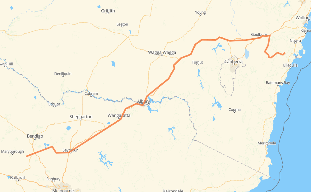
The distance from Newstead to Boolijah is 834 kilometers by road including 601 kilometers on motorways. Road takes approximately 8 hours and 21 minutes and goes through Wangaratta, Wodonga, Castlemaine, Wesley Hill, Heathcote, Puckapunyal and Seymour.
| Shortest distance by air | 608 km ✈️ |
| Car route length | 834 km 🚗 |
| Driving time | 8 h 21 min |
| Fuel amount | 66.7 L |
| Fuel cost | 132.1 CAD |
| Point | Distance | Time | Fuel | |
| Newstead | 0 km | 00 min | 0.0 L | |
|
B180 16 km, 11 min
|
||||
| Castlemaine | 16 km | 11 min | 1.0 L | |
|
B180 C326 63 km, 44 min
|
||||
| Heathcote | 79 km | 56 min | 5.3 L | |
|
B75 26 km, 18 min
|
||||
| Puckapunyal | 105 km | 1 h 14 min | 7.4 L | |
|
C384 19 km, 12 min
|
||||
| Seymour | 124 km | 1 h 27 min | 9.8 L | |
|
M31 57 km, 31 min
|
||||
| Euroa | 181 km | 1 h 58 min | 14.0 L | |
|
M31 19 km, 10 min
|
||||
| Violet Town | 200 km | 2 h 08 min | 15.3 L | |
|
M31 66 km, 35 min
|
||||
| Wangaratta | 266 km | 2 h 44 min | 21.0 L | |
|
M31 68 km, 37 min
|
||||
| Wodonga | 334 km | 3 h 21 min | 26.4 L | |
|
M31 501 km, 4 h 59 min
|
||||
| Boolijah | 834 km | 8 h 21 min | 64.1 L | |
Frequently Asked Questions
How much does it cost to drive from Newstead to Boolijah?
Fuel cost: 132.1 CAD
This fuel cost is calculated as: (Route length 834 km / 100 km) * (Fuel consumption 8 L/100 km) * (Fuel price 1.98 CAD / L)
You can adjust fuel consumption and fuel price here.
How long is a car ride from Newstead to Boolijah?
Driving time: 8 h 21 min
This time is calculated for driving at the maximum permitted speed, taking into account traffic rules restrictions.
- 594 km with a maximum speed 110 km/h = 5 h 24 min
- 155 km with a maximum speed 90 km/h = 1 h 43 min
- 74 km with a maximum speed 80 km/h = 55 min
- 1 km with a maximum speed 70 km/h = 1 min
- 3 km with a maximum speed 60 km/h = 3 min
- 2 km with a maximum speed 50 km/h = 2 min
- 4 km with a maximum speed 20 km/h = 11 min
The calculated driving time does not take into account intermediate stops and traffic jams.
How far is Newstead to Boolijah by land?
The distance between Newstead and Boolijah is 834 km by road including 601 km on motorways.
Precise satellite coordinates of highways were used for this calculation. The start and finish points are the centers of Newstead and Boolijah respectively.
How far is Newstead to Boolijah by plane?
The shortest distance (air line, as the crow flies) between Newstead and Boolijah is 608 km.
This distance is calculated using the Haversine formula as a great-circle distance between two points on the surface of a sphere. The start and finish points are the centers of Newstead and Boolijah respectively. Actual distance between airports may be different.
How many hours is Newstead from Boolijah by plane?
Boeing 737 airliner needs 45 min to cover the distance of 608 km at a cruising speed of 800 km/h.
Small plane "Cessna 172" needs 2 h 45 min to flight this distance at average speed of 220 km/h.
This time is approximate and do not take into account takeoff and landing times, airport location and other real world factors.
How long is a helicopter ride from Newstead to Boolijah?
Fast helicopter "Eurocopter AS350" or "Hughes OH-6 Cayuse" need 2 h 32 min to cover the distance of 608 km at a cruising speed of 240 km/h.
Popular "Robinson R44" needs 2 h 53 min to flight this distance at average speed of 210 km/h.
This time is approximate and do not take into account takeoff and landing times, aerodrome location and other real world factors.
What city is halfway between Newstead and Boolijah?
The halfway point between Newstead and Boolijah is Holbrook. It is located about 16 km from the exact midpoint by road.
The distance from Holbrook to Newstead is 401 km and driving will take about 3 h 57 min. The road between Holbrook and Boolijah has length 433 km and will take approximately 4 h 23 min.
The other cities located close to halfway point:
Where is Newstead in relation to Boolijah?
Newstead is located 608 km south-west of Boolijah.
Newstead has geographic coordinates: latitude -37.10729, longitude 144.06249.
Boolijah has geographic coordinates: latitude -35.05861, longitude 150.33222.
Which highway goes from Newstead to Boolijah?
The route from Newstead to Boolijah follows M31.
Other minor sections pass along the road:
- C384: 30 km
- B180: 29 km
- C326: 25 km
- B75: 16 km
- B400: 15 km
- A300: 1 km