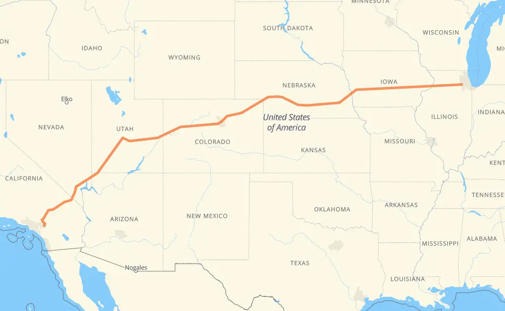
The distance from Naperville to Riverside is 3,149 kilometers by road including 3,142 kilometers on motorways. Road takes approximately 29 hours and 19 minutes and goes through Davenport, Iowa City, Omaha, Lincoln, North Platte, Denver and Vail.
How much does it cost to drive from Naperville to Riverside?
Fuel cost:
493.8 CAD
This fuel cost is calculated as: (Route length 3,149 km / 100 km) * (Fuel consumption 8 L/100 km) * (Fuel price 1.96 CAD / L)
You can adjust fuel consumption and fuel price here.
How long is a car ride from Naperville to Riverside?
Driving time:
29 h 19 min
This time is calculated for driving at the maximum permitted speed, taking into account traffic rules restrictions.
2,538 km with a maximum speed 110 km/h = 23 h 4 min
334 km with a maximum speed 105 km/h = 3 h 11 min
119 km with a maximum speed 100 km/h = 1 h 11 min
37 km with a maximum speed 97 km/h = 23 min
27 km with a maximum speed 89 km/h = 18 min
8 km with a maximum speed 80 km/h = 5 min
84 km with a maximum speed 80 km/h = 1 h 3 min
1 km with a maximum speed 56 km/h = 1 min
The calculated driving time does not take into account intermediate stops and traffic jams.
How far is Naperville to Riverside by land?
The distance between Naperville and Riverside is 3,149 km by road including 3,142 km on motorways.
Precise satellite coordinates of highways were used for this calculation. The start and finish points are the centers of Naperville and Riverside respectively.
How far is Naperville to Riverside by plane?
The shortest distance (air line, as the crow flies) between Naperville and Riverside is 2,696 km.
This distance is calculated using the Haversine formula as a great-circle distance between two points on the surface of a sphere. The start and finish points are the centers of Naperville and Riverside respectively. Actual distance between airports may be different.
How many hours is Naperville from Riverside by plane?
Boeing 737 airliner needs 3 h 22 min to cover the distance of 2,696 km at a cruising speed of 800 km/h.
Small plane "Cessna 172" needs 12 h 15 min to flight this distance at average speed of 220 km/h.
This time is approximate and do not take into account takeoff and landing times, airport location and other real world factors.
How long is a helicopter ride from Naperville to Riverside?
Fast helicopter "Eurocopter AS350" or "Hughes OH-6 Cayuse" need 11 h 14 min to cover the distance of 2,696 km at a cruising speed of 240 km/h.
Popular "Robinson R44" needs 12 h 50 min to flight this distance at average speed of 210 km/h.
This time is approximate and do not take into account takeoff and landing times, aerodrome location and other real world factors.
What city is halfway between Naperville and Riverside?
The halfway point between Naperville and Riverside is Wheat Ridge.
The distance from Wheat Ridge to Naperville is 1,574 km and driving will take about 14 h 27 min. The road between Wheat Ridge and Riverside has length 1,575 km and will take approximately 14 h 51 min.
The other cities located close to halfway point:
Denver is in 1,568 km from Naperville and 1,581 km from Riverside
Lakewood is in 1,581 km from Naperville and 1,568 km from Riverside
Thornton is in 1,555 km from Naperville and 1,594 km from Riverside
Where is Naperville in relation to Riverside?
Naperville is located 2,696 km east of Riverside.
Naperville has geographic coordinates: latitude 41.77291, longitude -88.14787.
Riverside has geographic coordinates: latitude 33.95335, longitude -117.39616.
Which highway goes from Naperville to Riverside?
The route from Naperville to Riverside follows I 80, I 70, I 15, US 6, I 76, US 50, IL 110, I 88.