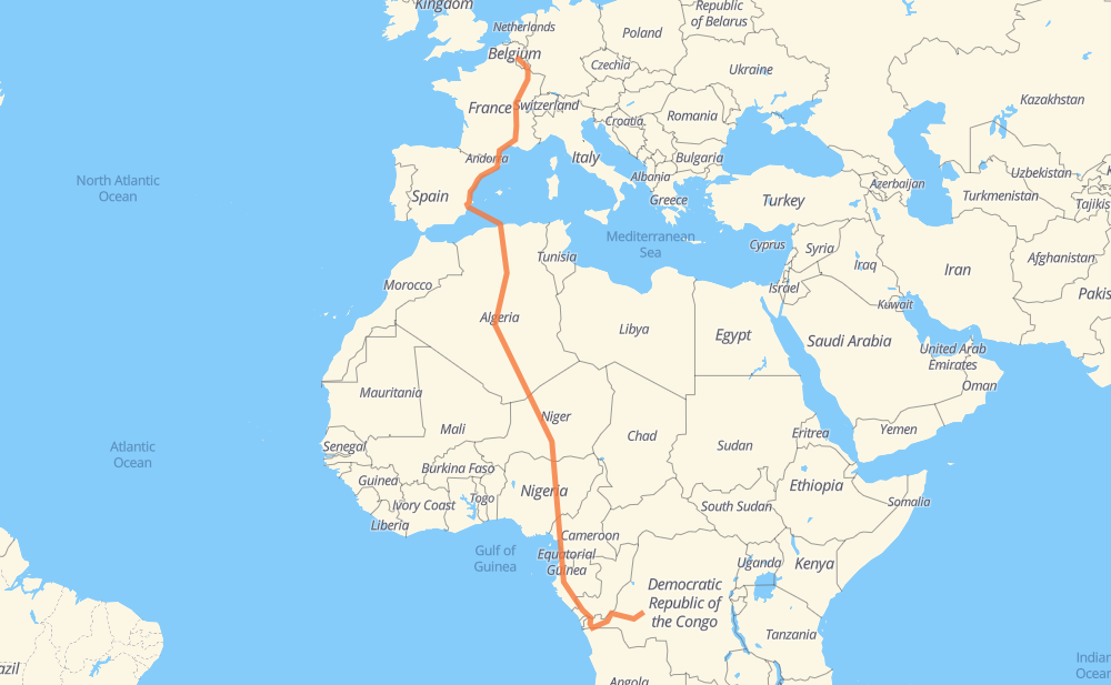
Distance between Mont and Saint Michel
The distance from Mont to Saint Michel is 9,720 kilometers by road including 2,131 kilometers on motorways. Road takes approximately 132 hours and 16 minutes and goes through Luxembourg, Metz, Lyon, Nîmes, Montpellier, Perpiñán and Castellón de la Plana.
| Shortest distance by air | 6,206 km ✈️ |
| Car route length | 9,720 km 🚗 |
| Driving time | 132 h 16 min |
| Fuel amount | 777.6 L |
| Fuel cost | 1,524.1 CAD |
| Point | Distance | Time | Fuel | |
| Mont | 0 km | 00 min | 0.0 L | |
|
E411 145 km, 1 h 23 min
|
||||
| Luxembourg | 145 km | 1 h 23 min | 11.2 L | |
|
A 6 A 31 60 km, 38 min
|
||||
| Metz | 204 km | 2 h 01 min | 16.2 L | |
|
A 31 454 km, 4 h 13 min
|
||||
| Lyon | 659 km | 6 h 15 min | 52.4 L | |
|
M 6 A 7 249 km, 2 h 19 min
|
||||
| Nîmes | 908 km | 8 h 35 min | 72.1 L | |
|
A 9 48 km, 25 min
|
||||
| Montpellier | 956 km | 9 h 01 min | 76.1 L | |
|
A 9 151 km, 1 h 22 min
|
||||
| Perpiñán | 1,106 km | 10 h 23 min | 88.0 L | |
|
A 9 AP-7 1,116 km, 25 h 30 min
|
||||
| Blida | 2,223 km | 35 h 54 min | 177.7 L | |
|
A1 RN 1 25 km, 17 min
|
||||
| Medea | 2,247 km | 36 h 12 min | 179.2 L | |
|
RN 1 126 km, 1 h 32 min
|
||||
| Ain Oussara | 2,373 km | 37 h 44 min | 187.7 L | |
|
RN 1 99 km, 1 h 15 min
|
||||
| Djelfa | 2,473 km | 38 h 59 min | 196.1 L | |
|
RN 1 102 km, 1 h 14 min
|
||||
| Laghouat | 2,575 km | 40 h 13 min | 204.7 L | |
|
RN 1 186 km, 2 h 07 min
|
||||
| Ghardaia | 2,761 km | 42 h 21 min | 220.2 L | |
|
RN 1 2,170 km, 27 h 10 min
|
||||
| Arlit | 4,932 km | 69 h 32 min | 394.5 L | |
|
N 25 240 km, 2 h 40 min
|
||||
| Agadez | 5,172 km | 72 h 12 min | 413.6 L | |
|
N 25 N 11 286 km, 3 h 25 min
|
||||
| Tanout | 5,458 km | 75 h 38 min | 436.2 L | |
|
N 11 151 km, 1 h 53 min
|
||||
| Zinder | 5,609 km | 77 h 31 min | 448.6 L | |
|
N 11 81 km, 1 h 00 min
|
||||
| Magaria | 5,690 km | 78 h 32 min | 452.6 L | |
|
N 11 F.244 162 km, 2 h 00 min
|
||||
| Kano | 5,852 km | 80 h 32 min | 468.1 L | |
|
A2 A3 508 km, 6 h 13 min
|
||||
| Lafia | 6,360 km | 86 h 46 min | 508.1 L | |
|
A3 N6 571 km, 7 h 06 min
|
||||
| Bamenda | 6,931 km | 93 h 52 min | 554.4 L | |
|
N6 77 km, 57 min
|
||||
| Bafoussam | 7,008 km | 94 h 49 min | 560.5 L | |
|
N6 N4 164 km, 2 h 02 min
|
||||
| Bafia | 7,172 km | 96 h 52 min | 572.8 L | |
|
N4 129 km, 1 h 36 min
|
||||
| Yaounde | 7,301 km | 98 h 28 min | 583.6 L | |
|
N1 N2 53 km, 39 min
|
||||
| Mbalmayo | 7,355 km | 99 h 08 min | 586.7 L | |
|
N2 108 km, 1 h 21 min
|
||||
| Ebolowa | 7,463 km | 100 h 30 min | 596.6 L | |
|
N 2 RN2 1,208 km, 14 h 52 min
|
||||
| Dolisie | 8,671 km | 115 h 22 min | 692.9 L | |
|
P2 RN1 511 km, 7 h 14 min
|
||||
| Mbanza-Ngungu | 9,182 km | 122 h 36 min | 733.5 L | |
|
RN1 386 km, 4 h 44 min
|
||||
| Kenge | 9,568 km | 127 h 20 min | 764.7 L | |
|
RN1 RN19 377 km, 4 h 54 min
|
||||
| Lekin Ngul | 9,945 km | 132 h 15 min | 795.5 L | |
Frequently Asked Questions
How much does it cost to drive from Mont to Saint Michel?
Fuel cost: 1,524.1 CAD
This fuel cost is calculated as: (Route length 9,720 km / 100 km) * (Fuel consumption 8 L/100 km) * (Fuel price 1.96 CAD / L)
You can adjust fuel consumption and fuel price here.
How long is a car ride from Mont to Saint Michel?
Driving time: 132 h 16 min
This time is calculated for driving at the maximum permitted speed, taking into account traffic rules restrictions.
- 1,556 km with a maximum speed 110 km/h = 14 h 8 min
- 243 km with a maximum speed 100 km/h = 2 h 26 min
- 2,160 km with a maximum speed 90 km/h = 24 h
- 5,079 km with a maximum speed 80 km/h = 63 h 28 min
- 21 km with a maximum speed 70 km/h = 17 min
- 274 km with a maximum speed 60 km/h = 4 h 33 min
- 238 km with a maximum speed 50 km/h = 4 h 45 min
- 5 km with a maximum speed 40 km/h = 7 min
- 1 km with a maximum speed 30 km/h = 2 min
- 368 km with a maximum speed 20 km/h = 18 h 25 min
The calculated driving time does not take into account intermediate stops and traffic jams.
How far is Mont to Saint Michel by land?
The distance between Mont and Saint Michel is 9,720 km by road including 2,131 km on motorways.
Precise satellite coordinates of highways were used for this calculation. The start and finish points are the centers of Mont and Saint Michel respectively.
How far is Mont to Saint Michel by plane?
The shortest distance (air line, as the crow flies) between Mont and Saint Michel is 6,206 km.
This distance is calculated using the Haversine formula as a great-circle distance between two points on the surface of a sphere. The start and finish points are the centers of Mont and Saint Michel respectively. Actual distance between airports may be different.
How many hours is Mont from Saint Michel by plane?
Boeing 737 airliner needs 7 h 45 min to cover the distance of 6,206 km at a cruising speed of 800 km/h.
Small plane "Cessna 172" needs 28 h 12 min to flight this distance at average speed of 220 km/h.
This time is approximate and do not take into account takeoff and landing times, airport location and other real world factors.
How long is a helicopter ride from Mont to Saint Michel?
Fast helicopter "Eurocopter AS350" or "Hughes OH-6 Cayuse" need 25 h 51 min to cover the distance of 6,206 km at a cruising speed of 240 km/h.
Popular "Robinson R44" needs 29 h 33 min to flight this distance at average speed of 210 km/h.
This time is approximate and do not take into account takeoff and landing times, aerodrome location and other real world factors.
What city is halfway between Mont and Saint Michel?
The halfway point between Mont and Saint Michel is Arlit. It is located about 72 km from the exact midpoint by road.
The distance from Arlit to Mont is 4,932 km and driving will take about 69 h 28 min. The road between Arlit and Saint Michel has length 4,788 km and will take approximately 62 h 47 min.
The other cities located close to halfway point:
Where is Mont in relation to Saint Michel?
Mont is located 6,206 km north of Saint Michel.
Mont has geographic coordinates: latitude 50.35362, longitude 4.90151.
Saint Michel has geographic coordinates: latitude -4.06112, longitude 19.24054.
Which highway goes from Mont to Saint Michel?
The route from Mont to Saint Michel follows RN 1, RN1, N 25, N 11, AP-7, RN2, A3, A 31, N6, A 9, N2, N4, A 7, RN 3, A 6, A-7, F.243, RN19, E411.
Other minor sections pass along the road:
- P2: 97 km
- F.244: 95 km
- A2: 86 km
- A236: 86 km
- A4: 82 km
- RS107: 53 km
- N 4: 49 km
- E25: 42 km
- A1: 40 km
- RN18: 35 km
- N1: 30 km
- RN12: 26 km
- N 2: 25 km
- RN 6: 20 km
- V-21: 18 km
- RS108: 14 km
- V-31: 14 km
- A 3: 13 km
- M 6: 10 km
- A-77: 7 km
- A344: 6 km
- M 7: 6 km
- N931: 5 km
- N3: 5 km
- N 1: 4 km
- A-31: 4 km
- A-70: 4 km
- ط و 1: 2 km
- RS103: 2 km
- RP101: 2 km
- RN 11: 2 km
- RS220: 1 km
- RN 8: 1 km