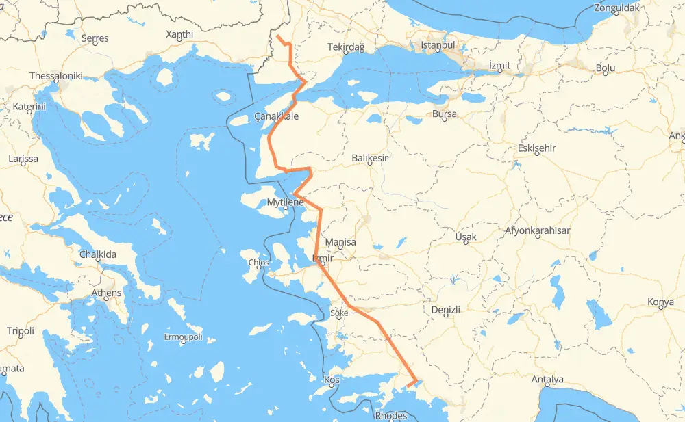
The distance from Meriç to Büyükkaraağaç is 772 kilometers by road including 189 kilometers on motorways. Road takes approximately 10 hours and goes through Çanakkale, Aydın, İstasyon Mahallesi, Gelibolu, Lapseki, Saltık and Ezine.
How much does it cost to drive from Meriç to Büyükkaraağaç?
Fuel cost:
121 CAD
This fuel cost is calculated as: (Route length 772 km / 100 km) * (Fuel consumption 8 L/100 km) * (Fuel price 1.96 CAD / L)
You can adjust fuel consumption and fuel price here.
How long is a car ride from Meriç to Büyükkaraağaç?
Driving time:
10 h
This time is calculated for driving at the maximum permitted speed, taking into account traffic rules restrictions.
170 km with a maximum speed 110 km/h = 1 h 32 min
5 km with a maximum speed 100 km/h = 2 min
392 km with a maximum speed 90 km/h = 4 h 21 min
175 km with a maximum speed 80 km/h = 2 h 10 min
33 km with a maximum speed 70 km/h = 28 min
56 km with a maximum speed 50 km/h = 1 h 7 min
1 km with a maximum speed 30 km/h = 1 min
5 km with a maximum speed 20 km/h = 15 min
The calculated driving time does not take into account intermediate stops and traffic jams.
How far is Meriç to Büyükkaraağaç by land?
The distance between Meriç and Büyükkaraağaç is 772 km by road including 189 km on motorways.
Precise satellite coordinates of highways were used for this calculation. The start and finish points are the centers of Meriç and Büyükkaraağaç respectively.
How far is Meriç to Büyükkaraağaç by plane?
The shortest distance (air line, as the crow flies) between Meriç and Büyükkaraağaç is 512 km.
This distance is calculated using the Haversine formula as a great-circle distance between two points on the surface of a sphere. The start and finish points are the centers of Meriç and Büyükkaraağaç respectively. Actual distance between airports may be different.
How many hours is Meriç from Büyükkaraağaç by plane?
Boeing 737 airliner needs 38 min to cover the distance of 512 km at a cruising speed of 800 km/h.
Small plane "Cessna 172" needs 2 h 19 min to flight this distance at average speed of 220 km/h.
This time is approximate and do not take into account takeoff and landing times, airport location and other real world factors.
How long is a helicopter ride from Meriç to Büyükkaraağaç?
Fast helicopter "Eurocopter AS350" or "Hughes OH-6 Cayuse" need 2 h 8 min to cover the distance of 512 km at a cruising speed of 240 km/h.
Popular "Robinson R44" needs 2 h 26 min to flight this distance at average speed of 210 km/h.
This time is approximate and do not take into account takeoff and landing times, aerodrome location and other real world factors.
What city is halfway between Meriç and Büyükkaraağaç?
The halfway point between Meriç and Büyükkaraağaç is Keremköy.
The distance from Keremköy to Meriç is 386 km and driving will take about 4 h 59 min. The road between Keremköy and Büyükkaraağaç has length 385 km and will take approximately 5 h 1 min.
The other cities located close to halfway point:
Gömeç is in 375 km from Meriç and 396 km from Büyükkaraağaç
Altınova is in 408 km from Meriç and 363 km from Büyükkaraağaç
Burhaniye is in 360 km from Meriç and 411 km from Büyükkaraağaç
Where is Meriç in relation to Büyükkaraağaç?
Meriç is located 512 km north-west of Büyükkaraağaç.
Meriç has geographic coordinates: latitude 41.19138, longitude 26.42076.
Büyükkaraağaç has geographic coordinates: latitude 36.87384, longitude 28.47294.
Which highway goes from Meriç to Büyükkaraağaç?
The route from Meriç to Büyükkaraağaç follows D550.