Distance between Meaford ON and Wapella SK
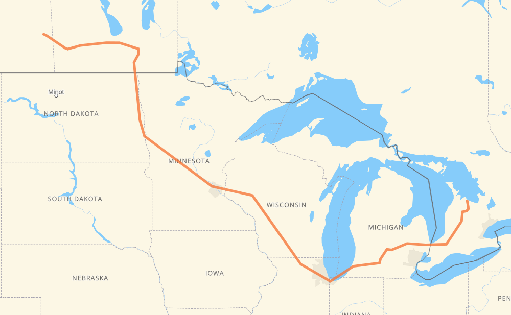
The distance from Meaford to Wapella is 2,607 kilometers by road including 1,874 kilometers on motorways. Road takes approximately 26 hours and 34 minutes and goes through Sarnia, Flint, Lansing, Kalamazoo, Chicago, Janesville and Madison.
| Shortest distance by air | 1,720 km ✈️ |
| Car route length | 2,607 km 🚗 |
| Driving time | 26 h 34 min |
| Fuel amount | 208.5 L |
| Fuel cost | 398.3 CAD |
| Point | Distance | Time | Fuel | |
| Meaford | 0 km | 00 min | 0.0 L | |
|
CR 7 23 290 km, 3 h 29 min
|
||||
| Sarnia | 290 km | 3 h 29 min | 22.5 L | |
|
402 I 69 122 km, 1 h 12 min
|
||||
| Flint | 412 km | 4 h 42 min | 32.6 L | |
|
I 69 99 km, 53 min
|
||||
| Lansing | 511 km | 5 h 36 min | 40.6 L | |
|
I 69 102 km, 55 min
|
||||
| Kalamazoo | 612 km | 6 h 32 min | 48.8 L | |
|
I 94 I 90 409 km, 3 h 53 min
|
||||
| Janesville | 1,021 km | 10 h 25 min | 81.4 L | |
|
I 39 56 km, 30 min
|
||||
| Madison | 1,078 km | 10 h 56 min | 85.5 L | |
|
I 39 I 94 282 km, 2 h 34 min
|
||||
| Eau Claire | 1,360 km | 13 h 31 min | 107.9 L | |
|
I 94 526 km, 4 h 52 min
|
||||
| Fargo | 1,886 km | 18 h 23 min | 150.1 L | |
|
I 29 102 km, 1 h 10 min
|
||||
| Grand Forks | 1,988 km | 19 h 34 min | 157.0 L | |
|
I 29 243 km, 2 h 47 min
|
||||
| Winnipeg | 2,231 km | 22 h 21 min | 177.5 L | |
|
PTH 100 PTH 1 88 km, 59 min
|
||||
| Portage la Prairie | 2,319 km | 23 h 20 min | 184.9 L | |
|
PTH 1 123 km, 1 h 22 min
|
||||
| Brandon | 2,442 km | 24 h 42 min | 195.0 L | |
|
PTH 1 168 km, 1 h 52 min
|
||||
| Wapella | 2,609 km | 26 h 35 min | 208.7 L | |
Frequently Asked Questions
How much does it cost to drive from Meaford to Wapella?
Fuel cost: 398.3 CAD
This fuel cost is calculated as: (Route length 2,607 km / 100 km) * (Fuel consumption 8 L/100 km) * (Fuel price 1.91 CAD / L)
You can adjust fuel consumption and fuel price here.
How long is a car ride from Meaford to Wapella?
Driving time: 26 h 34 min
This time is calculated for driving at the maximum permitted speed, taking into account traffic rules restrictions.
- 1,417 km with a maximum speed 110 km/h = 12 h 53 min
- 30 km with a maximum speed 105 km/h = 17 min
- 172 km with a maximum speed 100 km/h = 1 h 43 min
- 50 km with a maximum speed 97 km/h = 31 min
- 478 km with a maximum speed 90 km/h = 5 h 18 min
- 30 km with a maximum speed 89 km/h = 20 min
- 2 km with a maximum speed 80 km/h = 1 min
- 401 km with a maximum speed 80 km/h = 5 h
- 3 km with a maximum speed 72 km/h = 2 min
- 4 km with a maximum speed 70 km/h = 3 min
- 4 km with a maximum speed 60 km/h = 4 min
- 15 km with a maximum speed 50 km/h = 17 min
The calculated driving time does not take into account intermediate stops and traffic jams.
How far is Meaford to Wapella by land?
The distance between Meaford and Wapella is 2,607 km by road including 1,874 km on motorways.
Precise satellite coordinates of highways were used for this calculation. The start and finish points are the centers of Meaford and Wapella respectively.
How far is Meaford to Wapella by plane?
The shortest distance (air line, as the crow flies) between Meaford and Wapella is 1,720 km.
This distance is calculated using the Haversine formula as a great-circle distance between two points on the surface of a sphere. The start and finish points are the centers of Meaford and Wapella respectively. Actual distance between airports may be different.
How many hours is Meaford from Wapella by plane?
Boeing 737 airliner needs 2 h 9 min to cover the distance of 1,720 km at a cruising speed of 800 km/h.
Small plane "Cessna 172" needs 7 h 49 min to flight this distance at average speed of 220 km/h.
This time is approximate and do not take into account takeoff and landing times, airport location and other real world factors.
How long is a helicopter ride from Meaford to Wapella?
Fast helicopter "Eurocopter AS350" or "Hughes OH-6 Cayuse" need 7 h 10 min to cover the distance of 1,720 km at a cruising speed of 240 km/h.
Popular "Robinson R44" needs 8 h 11 min to flight this distance at average speed of 210 km/h.
This time is approximate and do not take into account takeoff and landing times, aerodrome location and other real world factors.
What city is halfway between Meaford and Wapella?
The halfway point between Meaford and Wapella is Northfield. It is located about 3 km from the exact midpoint by road.
The distance from Northfield to Meaford is 1,301 km and driving will take about 12 h 57 min. The road between Northfield and Wapella has length 1,306 km and will take approximately 13 h 36 min.
The other cities located close to halfway point:
Where is Meaford in relation to Wapella?
Meaford is located 1,720 km east of Wapella.
Meaford has geographic coordinates: latitude 44.60866, longitude -80.59146.
Wapella has geographic coordinates: latitude 50.26607, longitude -101.97411.
Which highway goes from Meaford to Wapella?
The route from Meaford to Wapella follows I 94, I 90, PTH 1, I 69, I 29, US 81, I 39.
Other minor sections pass along the road:
- 23: 96 km
- PTH 75: 94 km
- 402: 65 km
- I 694: 46 km
- 1: 44 km
- US 51: 30 km
- CR 7: 23 km
- 6: 22 km
- US 41: 22 km
- 4: 19 km
- PTH 100: 19 km
- US 59: 17 km
- 7: 16 km
- 19: 15 km
- 89: 14 km
- CR 13: 12 km
- CR 4: 9 km
- US 12: 9 km
- I 96: 8 km
- PTH 83: 7 km
- MN 95: 7 km
- PR 254: 5 km
- MN 210: 5 km
- 81: 5 km
- US 31: 5 km
- US 10: 5 km
- US 52: 4 km
- PR 241: 4 km
- WI 35: 4 km
- PR 250: 4 km
- US 20: 3 km
- WI 11: 3 km
- Route 42: 3 km
- PR 427: 2 km
- PR 334: 2 km
- 8: 2 km
- PTH 10: 2 km
- 26: 1 km
- CR 86: 1 km