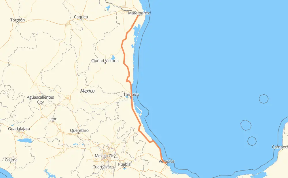
Distance between Matamoros and Veracruz
The distance from Matamoros to Veracruz is 952 kilometers by road including 145 kilometers on motorways. Road takes approximately 11 hours and 3 minutes and goes through Aldama, Ciudad Madero, General Francisco Villa, Altamira, Anáhuac, Alto Lucero and Túxpam de Rodríguez Cano.
| Shortest distance by air | 755 km ✈️ |
| Car route length | 952 km 🚗 |
| Driving time | 11 h 3 min |
| Fuel amount | 76.2 L |
| Fuel cost | 149.3 CAD |
| Toll roads cost | 606 + ? MXN |
| Point | Distance | Time | Fuel | |
| Matamoros | 0 km | 00 min | 0.0 L | |
|
MEX 2 MEX 101 89 km, 1 h 03 min
|
||||
| San Germán | 89 km | 1 h 03 min | 7.0 L | |
|
MEX 101 32 km, 21 min
|
||||
| General Francisco Villa | 122 km | 1 h 24 min | 9.2 L | |
|
MEX 101 MEX 180 267 km, 2 h 58 min
|
||||
| Aldama | 388 km | 4 h 23 min | 29.9 L | |
|
MEX 180 TAM 113 92 km, 1 h 05 min
|
||||
| Altamira | 480 km | 5 h 29 min | 37.8 L | |
|
MEX 80 MEX 180 17 km, 12 min
|
||||
| Ciudad Madero | 497 km | 5 h 41 min | 39.5 L | |
|
MEX 180 160 km, 1 h 47 min
|
||||
| Alto Lucero | 657 km | 7 h 29 min | 52.3 L | |
|
MEX 132 5 km, 04 min
|
||||
| Túxpam de Rodríguez Cano | 663 km | 7 h 33 min | 52.9 L | |
|
MEX 132 MEX 180 262 km, 3 h 06 min
|
||||
| José Cardel | 925 km | 10 h 40 min | 73.9 L | |
|
MEX 180 MEX 180D 35 km, 22 min
|
||||
| Veracruz | 960 km | 11 h 02 min | 76.3 L | |
Hotels of Veracruz
Frequently Asked Questions
How many toll booths are there from Matamoros to Veracruz?
There are 6 toll booths between Matamoros and Veracruz: Tampico, Naranjos, Tuxpan, Cardel - Posa Rica, Nautla and La Antigua.
How much does the toll booths cost from Matamoros to Veracruz?
Toll roads cost: Tampico (35 MXN) + Naranjos (297 MXN) + Tuxpan (45 MXN) + Cardel - Posa Rica (205 MXN) + Nautla (24 MXN) + La Antigua (?) = 606 + ? MXN
How much does it cost to drive from Matamoros to Veracruz?
Fuel cost: 149.3 CAD
This fuel cost is calculated as: (Route length 952 km / 100 km) * (Fuel consumption 8 L/100 km) * (Fuel price 1.96 CAD / L)
You can adjust fuel consumption and fuel price here.
Toll roads cost: 606 + ? MXN
How long is a car ride from Matamoros to Veracruz?
Driving time: 11 h 3 min
This time is calculated for driving at the maximum permitted speed, taking into account traffic rules restrictions.
- 22 km with a maximum speed 110 km/h = 11 min
- 83 km with a maximum speed 100 km/h = 49 min
- 543 km with a maximum speed 90 km/h = 6 h 2 min
- 297 km with a maximum speed 80 km/h = 3 h 42 min
- 13 km with a maximum speed 60 km/h = 12 min
- 2 km with a maximum speed 40 km/h = 3 min
The calculated driving time does not take into account intermediate stops and traffic jams.
How far is Matamoros to Veracruz by land?
The distance between Matamoros and Veracruz is 952 km by road including 145 km on motorways.
Precise satellite coordinates of highways were used for this calculation. The start and finish points are the centers of Matamoros and Veracruz respectively.
How far is Matamoros to Veracruz by plane?
The shortest distance (air line, as the crow flies) between Matamoros and Veracruz is 755 km.
This distance is calculated using the Haversine formula as a great-circle distance between two points on the surface of a sphere. The start and finish points are the centers of Matamoros and Veracruz respectively. Actual distance between airports may be different.
How many hours is Matamoros from Veracruz by plane?
Boeing 737 airliner needs 56 min to cover the distance of 755 km at a cruising speed of 800 km/h.
Small plane "Cessna 172" needs 3 h 25 min to flight this distance at average speed of 220 km/h.
This time is approximate and do not take into account takeoff and landing times, airport location and other real world factors.
How long is a helicopter ride from Matamoros to Veracruz?
Fast helicopter "Eurocopter AS350" or "Hughes OH-6 Cayuse" need 3 h 8 min to cover the distance of 755 km at a cruising speed of 240 km/h.
Popular "Robinson R44" needs 3 h 35 min to flight this distance at average speed of 210 km/h.
This time is approximate and do not take into account takeoff and landing times, aerodrome location and other real world factors.
What city is halfway between Matamoros and Veracruz?
The halfway point between Matamoros and Veracruz is Altamira. It is located about 4 km from the exact midpoint by road.
The distance from Altamira to Matamoros is 480 km and driving will take about 5 h 29 min. The road between Altamira and Veracruz has length 472 km and will take approximately 5 h 33 min.
The other cities located close to halfway point:
Where is Matamoros in relation to Veracruz?
Matamoros is located 755 km north of Veracruz.
Matamoros has geographic coordinates: latitude 25.87047, longitude -97.50668.
Veracruz has geographic coordinates: latitude 19.20022, longitude -96.13857.
Which highway goes from Matamoros to Veracruz?
The route from Matamoros to Veracruz follows MEX 180, MEX 101, MEX 180D.
Other minor sections pass along the road:
- TAM 113: 58 km
- MEX 135D: 45 km
- MEX: 30 km
- MEX 129: 23 km
- MEX 80: 18 km
- MEX 132D: 13 km
- MEX 132: 10 km
- MEX 2: 2 km