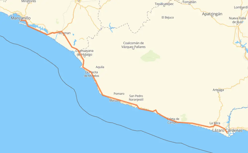
Distance between Manzanillo and Lázaro Cárdenas
The distance from Manzanillo to Lázaro Cárdenas is 336 kilometers by road including 48 kilometers on motorways. Road takes approximately 4 hours and 1 minute and goes through Cuyutlán, Ciudad de Armería, Tecoman, La Mira, Buenos Aires and La Orilla.
| Shortest distance by air | 254 km ✈️ |
| Car route length | 336 km 🚗 |
| Driving time | 4 h 1 min |
| Fuel amount | 26.9 L |
| Fuel cost | 52.7 CAD |
| Toll roads cost | 0 + ? |
| Point | Distance | Time | Fuel | |
| Manzanillo | 0 km | 00 min | 0.0 L | |
|
MEX 200 MEX 200D 26 km, 19 min
|
||||
| Cuyutlán | 26 km | 19 min | 1.1 L | |
|
MEX 200D 18 km, 13 min
|
||||
| Ciudad de Armería | 44 km | 32 min | 3.1 L | |
|
MEX 200D 7 km, 05 min
|
||||
| Colonia Bayardo | 51 km | 37 min | 3.9 L | |
|
MEX 200D MEX 200 7 km, 04 min
|
||||
| Tecoman | 58 km | 42 min | 4.3 L | |
|
MEX 200 6 km, 04 min
|
||||
| Cofradía de Morelos | 64 km | 47 min | 5.0 L | |
|
MEX 200 256 km, 3 h 01 min
|
||||
| La Mira | 320 km | 3 h 48 min | 25.2 L | |
|
MEX 200 5 km, 04 min
|
||||
| Buenos Aires | 325 km | 3 h 52 min | 26.0 L | |
|
MEX 200 5 km, 03 min
|
||||
| La Orilla | 330 km | 3 h 56 min | 26.4 L | |
|
MEX 200 6 km, 04 min
|
||||
| Lázaro Cárdenas | 336 km | 4 h 01 min | 26.4 L | |
Hotels of Lázaro Cárdenas
Frequently Asked Questions
How many toll booths are there from Manzanillo to Lázaro Cárdenas?
There are 1 tollbooth between Manzanillo and Lázaro Cárdenas: Cuyutlan.
How much does the toll booths cost from Manzanillo to Lázaro Cárdenas?
Toll roads cost: Cuyutlan (?) = 0 + ?
How much does it cost to drive from Manzanillo to Lázaro Cárdenas?
Fuel cost: 52.7 CAD
This fuel cost is calculated as: (Route length 336 km / 100 km) * (Fuel consumption 8 L/100 km) * (Fuel price 1.96 CAD / L)
You can adjust fuel consumption and fuel price here.
Toll roads cost: 0 + ?
How long is a car ride from Manzanillo to Lázaro Cárdenas?
Driving time: 4 h 1 min
This time is calculated for driving at the maximum permitted speed, taking into account traffic rules restrictions.
- 9 km with a maximum speed 100 km/h = 5 min
- 129 km with a maximum speed 90 km/h = 1 h 26 min
- 195 km with a maximum speed 80 km/h = 2 h 26 min
- 3 km with a maximum speed 50 km/h = 3 min
The calculated driving time does not take into account intermediate stops and traffic jams.
How far is Manzanillo to Lázaro Cárdenas by land?
The distance between Manzanillo and Lázaro Cárdenas is 336 km by road including 48 km on motorways.
Precise satellite coordinates of highways were used for this calculation. The start and finish points are the centers of Manzanillo and Lázaro Cárdenas respectively.
How far is Manzanillo to Lázaro Cárdenas by plane?
The shortest distance (air line, as the crow flies) between Manzanillo and Lázaro Cárdenas is 254 km.
This distance is calculated using the Haversine formula as a great-circle distance between two points on the surface of a sphere. The start and finish points are the centers of Manzanillo and Lázaro Cárdenas respectively. Actual distance between airports may be different.
How many hours is Manzanillo from Lázaro Cárdenas by plane?
Boeing 737 airliner needs 19 min to cover the distance of 254 km at a cruising speed of 800 km/h.
Small plane "Cessna 172" needs 1 h 9 min to flight this distance at average speed of 220 km/h.
This time is approximate and do not take into account takeoff and landing times, airport location and other real world factors.
How long is a helicopter ride from Manzanillo to Lázaro Cárdenas?
Fast helicopter "Eurocopter AS350" or "Hughes OH-6 Cayuse" need 1 h 3 min to cover the distance of 254 km at a cruising speed of 240 km/h.
Popular "Robinson R44" needs 1 h 12 min to flight this distance at average speed of 210 km/h.
This time is approximate and do not take into account takeoff and landing times, aerodrome location and other real world factors.
What city is halfway between Manzanillo and Lázaro Cárdenas?
The halfway point between Manzanillo and Lázaro Cárdenas is Maruata. It is located about 3 km from the exact midpoint by road.
The distance from Maruata to Manzanillo is 165 km and driving will take about 1 h 58 min. The road between Maruata and Lázaro Cárdenas has length 171 km and will take approximately 2 h 2 min.
The other cities located close to halfway point:
Where is Manzanillo in relation to Lázaro Cárdenas?
Manzanillo is located 254 km north-west of Lázaro Cárdenas.
Manzanillo has geographic coordinates: latitude 19.05063, longitude -104.316.
Lázaro Cárdenas has geographic coordinates: latitude 17.95948, longitude -102.19866.
Which highway goes from Manzanillo to Lázaro Cárdenas?
The route from Manzanillo to Lázaro Cárdenas follows MEX 200.
Other minor sections pass along the road:
- MEX 200D: 47 km
- MEX 37: 2 km