Distance between Mansourah and Bad
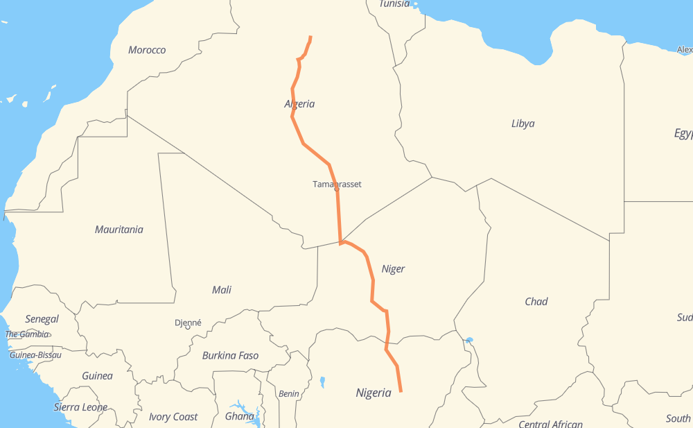
The distance from Mansourah to Bad is 3,147 kilometers by road. Road takes approximately 41 hours and 49 minutes and goes through Arlit, Agadez, Tanout, Zinder and Magaria.
| Shortest distance by air | 2,568 km ✈️ |
| Car route length | 3,147 km 🚗 |
| Driving time | 41 h 49 min |
| Fuel amount | 251.8 L |
| Fuel cost | 493.5 CAD |
| Point | Distance | Time | Fuel | |
| Mansourah | 0 km | 00 min | 0.0 L | |
|
RN 1 123 km, 1 h 26 min
|
||||
| El Menia | 123 km | 1 h 26 min | 3.7 L | |
|
RN 1 414 km, 4 h 47 min
|
||||
| In Salah | 537 km | 6 h 14 min | 16.3 L | |
|
RN 1 726 km, 9 h 30 min
|
||||
| Tamanrasset | 1,263 km | 15 h 45 min | 100.7 L | |
|
RN 1 N 25 830 km, 10 h 25 min
|
||||
| Arlit | 2,093 km | 26 h 10 min | 167.4 L | |
|
N 25 240 km, 2 h 40 min
|
||||
| Agadez | 2,333 km | 28 h 51 min | 186.5 L | |
|
N 25 N 11 286 km, 3 h 25 min
|
||||
| Tanout | 2,619 km | 32 h 16 min | 209.1 L | |
|
N 11 151 km, 1 h 53 min
|
||||
| Zinder | 2,770 km | 34 h 10 min | 221.5 L | |
|
N 11 81 km, 1 h 00 min
|
||||
| Magaria | 2,851 km | 35 h 10 min | 225.5 L | |
|
N 11 F.244 509 km, 6 h 38 min
|
||||
| Gyangyan | 3,360 km | 41 h 48 min | 268.5 L | |
Frequently Asked Questions
How much does it cost to drive from Mansourah to Bad?
Fuel cost: 493.5 CAD
This fuel cost is calculated as: (Route length 3,147 km / 100 km) * (Fuel consumption 8 L/100 km) * (Fuel price 1.96 CAD / L)
You can adjust fuel consumption and fuel price here.
How long is a car ride from Mansourah to Bad?
Driving time: 41 h 49 min
This time is calculated for driving at the maximum permitted speed, taking into account traffic rules restrictions.
- 1,238 km with a maximum speed 90 km/h = 13 h 45 min
- 1,804 km with a maximum speed 80 km/h = 22 h 33 min
- 255 km with a maximum speed 60 km/h = 4 h 15 min
- 61 km with a maximum speed 50 km/h = 1 h 13 min
The calculated driving time does not take into account intermediate stops and traffic jams.
How far is Mansourah to Bad by land?
The distance between Mansourah and Bad is 3,147 km by road.
Precise satellite coordinates of highways were used for this calculation. The start and finish points are the centers of Mansourah and Bad respectively.
How far is Mansourah to Bad by plane?
The shortest distance (air line, as the crow flies) between Mansourah and Bad is 2,568 km.
This distance is calculated using the Haversine formula as a great-circle distance between two points on the surface of a sphere. The start and finish points are the centers of Mansourah and Bad respectively. Actual distance between airports may be different.
How many hours is Mansourah from Bad by plane?
Boeing 737 airliner needs 3 h 12 min to cover the distance of 2,568 km at a cruising speed of 800 km/h.
Small plane "Cessna 172" needs 11 h 40 min to flight this distance at average speed of 220 km/h.
This time is approximate and do not take into account takeoff and landing times, airport location and other real world factors.
How long is a helicopter ride from Mansourah to Bad?
Fast helicopter "Eurocopter AS350" or "Hughes OH-6 Cayuse" need 10 h 42 min to cover the distance of 2,568 km at a cruising speed of 240 km/h.
Popular "Robinson R44" needs 12 h 13 min to flight this distance at average speed of 210 km/h.
This time is approximate and do not take into account takeoff and landing times, aerodrome location and other real world factors.
What city is halfway between Mansourah and Bad?
The halfway point between Mansourah and Bad is In Guezzam. It is located about 78 km from the exact midpoint by road.
The distance from In Guezzam to Mansourah is 1,496 km and driving will take about 18 h 41 min. The road between In Guezzam and Bad has length 1,651 km and will take approximately 23 h 7 min.
The other cities located close to halfway point:
Where is Mansourah in relation to Bad?
Mansourah is located 2,568 km north-west of Bad.
Mansourah has geographic coordinates: latitude 31.97869, longitude 3.74813.
Bad has geographic coordinates: latitude 9.6, longitude 9.86666.
Which highway goes from Mansourah to Bad?
The route from Mansourah to Bad follows RN 1, N 25, N 11.
Other minor sections pass along the road:
- F.244: 49 km
- A237: 43 km
- F.247: 30 km
- F.130: 18 km
- A3: 4 km
- F.131: 3 km
- ط و 1: 2 km