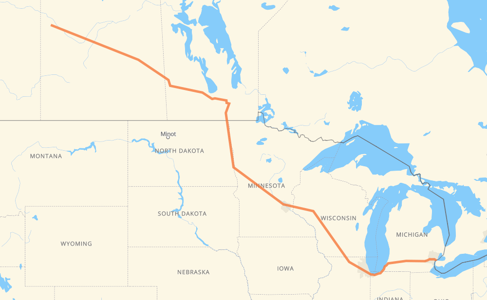
Distance between Maidstone SK and Windsor ON
The distance from Maidstone to Windsor is 2,841 kilometers by road including 1,765 kilometers on motorways. Road takes approximately 29 hours and 19 minutes and goes through North Battleford, Saskatoon, Yorkton, Portage la Prairie, Winnipeg, Grand Forks and Fargo.
| Shortest distance by air | 2,284 km ✈️ |
| Car route length | 2,841 km 🚗 |
| Driving time | 29 h 19 min |
| Fuel amount | 227.3 L |
| Fuel cost | 447.8 CAD |
| Point | Distance | Time | Fuel | |
| Maidstone | 0 km | 00 min | 0.0 L | |
|
16 59 km, 40 min
|
||||
| North Battleford | 59 km | 40 min | 2.5 L | |
|
16 162 km, 1 h 51 min
|
||||
| Saskatoon | 221 km | 2 h 31 min | 17.1 L | |
|
16 325 km, 3 h 37 min
|
||||
| Yorkton | 546 km | 6 h 09 min | 43.2 L | |
|
16 PTH 16 369 km, 4 h 14 min
|
||||
| Portage la Prairie | 915 km | 10 h 24 min | 72.6 L | |
|
PTH 1 85 km, 58 min
|
||||
| Winnipeg | 1,000 km | 11 h 22 min | 78.9 L | |
|
PTH 100 I 29 228 km, 2 h 34 min
|
||||
| Grand Forks | 1,228 km | 13 h 57 min | 97.7 L | |
|
I 29 119 km, 1 h 17 min
|
||||
| Fargo | 1,347 km | 15 h 14 min | 107.0 L | |
|
I 29 I 94 526 km, 5 h 02 min
|
||||
| Eau Claire | 1,873 km | 20 h 16 min | 148.9 L | |
|
I 94 282 km, 2 h 34 min
|
||||
| Madison | 2,156 km | 22 h 51 min | 171.7 L | |
|
I 39 56 km, 30 min
|
||||
| Janesville | 2,211 km | 23 h 21 min | 176.6 L | |
|
I 39 I 90 173 km, 1 h 39 min
|
||||
| Chicago | 2,385 km | 25 h 01 min | 188.9 L | |
|
I 90 I 94 231 km, 2 h 12 min
|
||||
| Kalamazoo | 2,616 km | 27 h 13 min | 209.2 L | |
|
I 94 154 km, 1 h 24 min
|
||||
| Ann Arbor | 2,771 km | 28 h 37 min | 221.5 L | |
|
M 14 56 km, 31 min
|
||||
| Detroit | 2,827 km | 29 h 09 min | 225.1 L | |
|
I 96 15 km, 09 min
|
||||
| Windsor | 2,841 km | 29 h 18 min | 227.2 L | |
Hotels of Windsor
Frequently Asked Questions
How much does it cost to drive from Maidstone to Windsor?
Fuel cost: 447.8 CAD
This fuel cost is calculated as: (Route length 2,841 km / 100 km) * (Fuel consumption 8 L/100 km) * (Fuel price 1.97 CAD / L)
You can adjust fuel consumption and fuel price here.
How long is a car ride from Maidstone to Windsor?
Driving time: 29 h 19 min
This time is calculated for driving at the maximum permitted speed, taking into account traffic rules restrictions.
- 1,244 km with a maximum speed 110 km/h = 11 h 18 min
- 29 km with a maximum speed 105 km/h = 16 min
- 229 km with a maximum speed 100 km/h = 2 h 17 min
- 33 km with a maximum speed 97 km/h = 20 min
- 934 km with a maximum speed 90 km/h = 10 h 22 min
- 43 km with a maximum speed 89 km/h = 28 min
- 294 km with a maximum speed 80 km/h = 3 h 40 min
- 14 km with a maximum speed 72 km/h = 11 min
- 8 km with a maximum speed 70 km/h = 6 min
- 6 km with a maximum speed 60 km/h = 5 min
- 1 km with a maximum speed 56 km/h = 1 min
- 5 km with a maximum speed 50 km/h = 6 min
The calculated driving time does not take into account intermediate stops and traffic jams.
How far is Maidstone to Windsor by land?
The distance between Maidstone and Windsor is 2,841 km by road including 1,765 km on motorways.
Precise satellite coordinates of highways were used for this calculation. The start and finish points are the centers of Maidstone and Windsor respectively.
How far is Maidstone to Windsor by plane?
The shortest distance (air line, as the crow flies) between Maidstone and Windsor is 2,284 km.
This distance is calculated using the Haversine formula as a great-circle distance between two points on the surface of a sphere. The start and finish points are the centers of Maidstone and Windsor respectively. Actual distance between airports may be different.
How many hours is Maidstone from Windsor by plane?
Boeing 737 airliner needs 2 h 51 min to cover the distance of 2,284 km at a cruising speed of 800 km/h.
Small plane "Cessna 172" needs 10 h 22 min to flight this distance at average speed of 220 km/h.
This time is approximate and do not take into account takeoff and landing times, airport location and other real world factors.
How long is a helicopter ride from Maidstone to Windsor?
Fast helicopter "Eurocopter AS350" or "Hughes OH-6 Cayuse" need 9 h 31 min to cover the distance of 2,284 km at a cruising speed of 240 km/h.
Popular "Robinson R44" needs 10 h 52 min to flight this distance at average speed of 210 km/h.
This time is approximate and do not take into account takeoff and landing times, aerodrome location and other real world factors.
What city is halfway between Maidstone and Windsor?
The halfway point between Maidstone and Windsor is Fergus Falls. It is located about 25 km from the exact midpoint by road.
The distance from Fergus Falls to Maidstone is 1,445 km and driving will take about 16 h 12 min. The road between Fergus Falls and Windsor has length 1,396 km and will take approximately 13 h 6 min.
The other cities located close to halfway point:
Where is Maidstone in relation to Windsor?
Maidstone is located 2,284 km north-west of Windsor.
Maidstone has geographic coordinates: latitude 53.08611, longitude -109.29647.
Windsor has geographic coordinates: latitude 42.30423, longitude -83.02986.
Which highway goes from Maidstone to Windsor?
The route from Maidstone to Windsor follows I 94, 16, I 90, PTH 16, I 29, US 81, I 39.
Other minor sections pass along the road:
- PTH 75: 93 km
- PTH 1: 85 km
- I 694: 46 km
- PTH 83: 37 km
- M 14: 34 km
- US 51: 32 km
- I 96: 32 km
- PTH 100: 23 km
- US 59: 17 km
- 11: 13 km
- 20: 10 km
- US 10: 7 km
- MN 95: 6 km
- PTH 10: 6 km
- US 12: 6 km
- US 127: 5 km
- 6: 5 km
- MN 210: 5 km
- US 52: 5 km
- US 31: 5 km
- 674: 5 km
- 40: 5 km
- WI 35: 4 km
- PR 264: 3 km
- 9: 3 km
- US 23: 3 km
- WI 11: 3 km
- Route 42: 2 km
- M 10: 2 km
- 12: 2 km
- US 23 Business: 2 km
- 10: 2 km
- PR 250: 2 km
- PTH 5: 1 km
- 4: 1 km