Distance between mahalle ? and mahalle
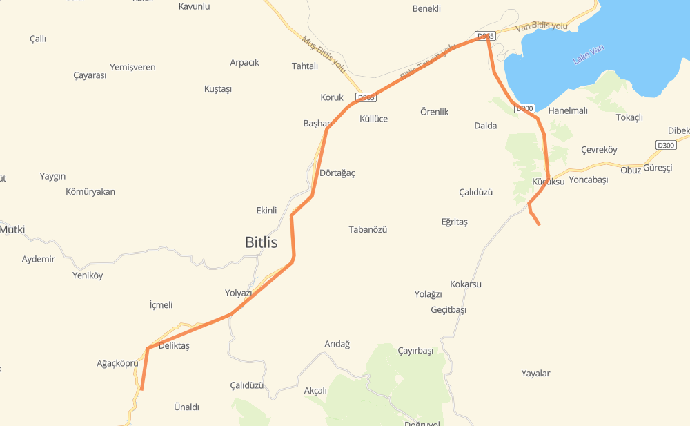
The distance from mahalle ? to mahalle is 52 kilometers by road. Road takes approximately 38 minutes and goes through Bitlis, Beş Minare Mahallesi, Karşıyaka Mah., Güzeldere and mahalle.
| Shortest distance by air | 28 km ✈️ |
| Car route length | 52 km 🚗 |
| Driving time | 38 min |
| Fuel amount | 4.1 L |
| Fuel cost | 8.1 CAD |
| Point | Distance | Time | Fuel | |
| mahalle ? | 0 km | 00 min | 0.0 L | |
|
D965 10 km, 07 min
|
||||
| Tatlıkaynak | 10 km | 07 min | 0.5 L | |
|
D965 6 km, 04 min
|
||||
| Bitlis | 16 km | 12 min | 1.0 L | |
|
D965 8 km, 05 min
|
||||
| Beş Minare Mahallesi | 24 km | 18 min | 1.7 L | |
|
D965 14 km, 09 min
|
||||
| Karşıyaka Mah. | 38 km | 27 min | 3.0 L | |
|
D965 D300 8 km, 05 min
|
||||
| Güzeldere | 46 km | 33 min | 3.5 L | |
|
D300 13-05 6 km, 05 min
|
||||
| mahalle | 52 km | 38 min | 3.9 L | |
Frequently Asked Questions
How much does it cost to drive from mahalle ? to mahalle?
Fuel cost: 8.1 CAD
This fuel cost is calculated as: (Route length 52 km / 100 km) * (Fuel consumption 8 L/100 km) * (Fuel price 1.96 CAD / L)
You can adjust fuel consumption and fuel price here.
How long is a car ride from mahalle ? to mahalle?
Driving time: 38 min
This time is calculated for driving at the maximum permitted speed, taking into account traffic rules restrictions.
- 22 km with a maximum speed 90 km/h = 14 min
- 27 km with a maximum speed 80 km/h = 20 min
- 3 km with a maximum speed 50 km/h = 3 min
The calculated driving time does not take into account intermediate stops and traffic jams.
How far is mahalle ? to mahalle by land?
The distance between mahalle ? and mahalle is 52 km by road.
Precise satellite coordinates of highways were used for this calculation. The start and finish points are the centers of mahalle ? and mahalle respectively.
What city is halfway between mahalle ? and mahalle?
The halfway point between mahalle ? and mahalle is Beş Minare Mahallesi. It is located about 2 km from the exact midpoint by road.
The distance from Beş Minare Mahallesi to mahalle ? is 24 km and driving will take about 18 min. The road between Beş Minare Mahallesi and mahalle has length 28 km and will take approximately 20 min.
Where is mahalle ? in relation to mahalle?
mahalle ? is located 28 km south-west of mahalle.
mahalle ? has geographic coordinates: latitude 38.31936, longitude 42.01986.
mahalle has geographic coordinates: latitude 38.41493, longitude 42.31381.
Which highway goes from mahalle ? to mahalle?
The route from mahalle ? to mahalle follows D965, D300.
Other minor sections pass along the road:
- 13-05: 2 km