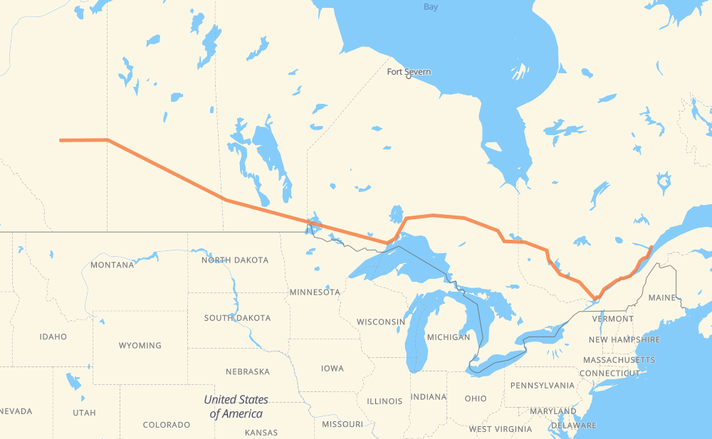
The distance from Leduc to Les Bergeronnes is 4,083 kilometers by road including 450 kilometers on motorways. Road takes approximately 46 hours and 10 minutes and goes through Edmonton, Sherwood Park, Lloydminster, North Battleford, Saskatoon, Yorkton and Portage la Prairie.
How much does it cost to drive from Leduc to Les Bergeronnes?
Fuel cost:
643.5 CAD
This fuel cost is calculated as: (Route length 4,083 km / 100 km) * (Fuel consumption 8 L/100 km) * (Fuel price 1.97 CAD / L)
You can adjust fuel consumption and fuel price here.
How long is a car ride from Leduc to Les Bergeronnes?
Driving time:
46 h 10 min
This time is calculated for driving at the maximum permitted speed, taking into account traffic rules restrictions.
20 km with a maximum speed 110 km/h = 10 min
388 km with a maximum speed 100 km/h = 3 h 53 min
3,277 km with a maximum speed 90 km/h = 36 h 24 min
229 km with a maximum speed 80 km/h = 2 h 51 min
88 km with a maximum speed 70 km/h = 1 h 15 min
25 km with a maximum speed 60 km/h = 24 min
52 km with a maximum speed 50 km/h = 1 h 2 min
2 km with a maximum speed 20 km/h = 4 min
The calculated driving time does not take into account intermediate stops and traffic jams.
How far is Leduc to Les Bergeronnes by land?
The distance between Leduc and Les Bergeronnes is 4,083 km by road including 450 km on motorways.
Precise satellite coordinates of highways were used for this calculation. The start and finish points are the centers of Leduc and Les Bergeronnes respectively.
How far is Leduc to Les Bergeronnes by plane?
The shortest distance (air line, as the crow flies) between Leduc and Les Bergeronnes is 3,095 km.
This distance is calculated using the Haversine formula as a great-circle distance between two points on the surface of a sphere. The start and finish points are the centers of Leduc and Les Bergeronnes respectively. Actual distance between airports may be different.
How many hours is Leduc from Les Bergeronnes by plane?
Boeing 737 airliner needs 3 h 52 min to cover the distance of 3,095 km at a cruising speed of 800 km/h.
Small plane "Cessna 172" needs 14 h 4 min to flight this distance at average speed of 220 km/h.
This time is approximate and do not take into account takeoff and landing times, airport location and other real world factors.
How long is a helicopter ride from Leduc to Les Bergeronnes?
Fast helicopter "Eurocopter AS350" or "Hughes OH-6 Cayuse" need 12 h 53 min to cover the distance of 3,095 km at a cruising speed of 240 km/h.
Popular "Robinson R44" needs 14 h 44 min to flight this distance at average speed of 210 km/h.
This time is approximate and do not take into account takeoff and landing times, aerodrome location and other real world factors.
What city is halfway between Leduc and Les Bergeronnes?
The halfway point between Leduc and Les Bergeronnes is Thunder Bay. It is located about 6 km from the exact midpoint by road.
The distance from Thunder Bay to Leduc is 2,035 km and driving will take about 22 h 55 min. The road between Thunder Bay and Les Bergeronnes has length 2,048 km and will take approximately 23 h 15 min.
The other cities located close to halfway point:
Dorion is in 2,101 km from Leduc and 1,982 km from Les Bergeronnes
Nipigon is in 2,143 km from Leduc and 1,940 km from Les Bergeronnes
Orient Bay is in 2,172 km from Leduc and 1,912 km from Les Bergeronnes
Where is Leduc in relation to Les Bergeronnes?
Leduc is located 3,095 km west of Les Bergeronnes.
Leduc has geographic coordinates: latitude 53.26193, longitude -113.55194.
Les Bergeronnes has geographic coordinates: latitude 48.24388, longitude -69.54552.
Which highway goes from Leduc to Les Bergeronnes?
The route from Leduc to Les Bergeronnes follows 16, 11, 17, 117, PTH 16, 40, PTH 1, 138, 101.